Bryan Norcross: Tropical Storm Watches or Warnings likely for Florida on Friday
If sustained winds associated with the circulation reach 40 mph, the system will be named Tropical Storm Debby.

Bryan Norcross talks future of Potential Tropical Cyclone 4
FOX Weather Hurricane Specialist says that while the path of Potential Tropical Cyclone Four is becoming clearer, there is still a lot of uncertainty surrounding its future.
Updated at 9:30 a.m. ET Friday, August 2, 2024
The tropical disturbance we've been tracking across the Caribbean islands, officially designated Invest 97L by the National Hurricane Center, is over the eastern end of Cuba. It's still being disrupted by land and high terrain – mountains in that part of the island reach over 6000 feet. The loose center of the disturbance will move over a good part of Cuba on Friday and emerge into the southern Gulf of Mexico on Friday night or early Saturday.
The upper-level wind pattern looks somewhere between moderately and very conducive for a tropical depression or tropical storm to develop. The NHC has the odds of development at 90%. Those odds only refer to the chance that a tropical depression will develop, but unless the system tracks very close to Florida and its development is slowed by interaction with land, intensification into at least a tropical storm looks likely.
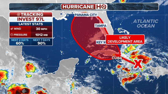
The outlook for Invest 97L in the Atlantic.
(FOX Weather)
If sustained winds associated with the circulation reach 40 mph, the system will be named Tropical Storm Debby. Because that's a possibility, the NHC will likely issue Tropical Storm Watches or Warnings for some part of Florida on Friday, even before the system organizes. If they do that, the disturbance will be designated a Potential Tropical Cyclone, which is just a technical name for a Potential Tropical Threat.
The eventual track of potential-Debby is still quite uncertain for a number of reasons. For one thing, until the center clears Cuba, the effect on the track from the system's interaction with land is unknowable. Also, the strength of the system when it reaches the Gulf will affect how it interacts with the steering currents and therefore exactly where the center tracks.
The consensus of the various computer forecast models is that the system will arc to the right as it reaches the northern Gulf. Where exactly that turn takes place and if it happens at all is an open question. A dip in the jet stream moving across the northern part of the US is pulling potential-Debby north.
Many of the computer forecast models show the system impacting the coast of Georgia and/or the Carolinas after the weekend - some show a strong tropical storm or hurricane. Others show the system stalling in the Gulf.
How much of a grip the jet stream dip has on the system next week will dictate whether it makes steady progress across Florida and somewhere near the Southeast coast or it slows down and stalls, loops, or otherwise delays its move in any definitive direction.
It's too early to know the details of what's going to happen, although the details are exactly what everybody wants to know, obviously. When a system moves into the Gulf, there's always a concern that it could intensify quickly because we've seen it happen so many times. In this case, since we don't know what condition the disturbance will be in when it clears Cuba, we can't estimate with any certainty how strong it could get and how quickly. But we have to be ready.
If Debby does develop and starts to strengthen, the preparation window on the west coast of Florida will be short.
For now, be aware that waves of gusty tropical downpours will likely arrive over the southern Florida peninsula by early Saturday and move up the state. Plan to stay well-informed this weekend on how potential-Debby is developing and the latest forecasts.
This system will be at least of moderate size, which means it will produce more storm surge than a small, tightly-wound storm. We all know what significant storms can do on the Gulf coast. Stay aware and be prepared. Just in case.