Bryan Norcross: Remembering Hurricane Andrew 4 days before landfall as 2024 tropics go quiet
In the tropics today, nothing is cooking. Most macro factors are in place for an explosion of tropical activity, but fortunately, the large-scale flow in the atmosphere is moving disturbances off Africa unusually far north.

FOX Weather is your Hurricane HQ.
(FOX Weather)
Updated at 9 a.m. ET on Tuesday, August 20, 2024
On this day 32 years ago, Tropical Storm Andrew was giving us a head fake. In the morning, Hurricane Hunters found a broad disorganized circulation with unusually high pressure at the center. It was on the edge of dissipating.
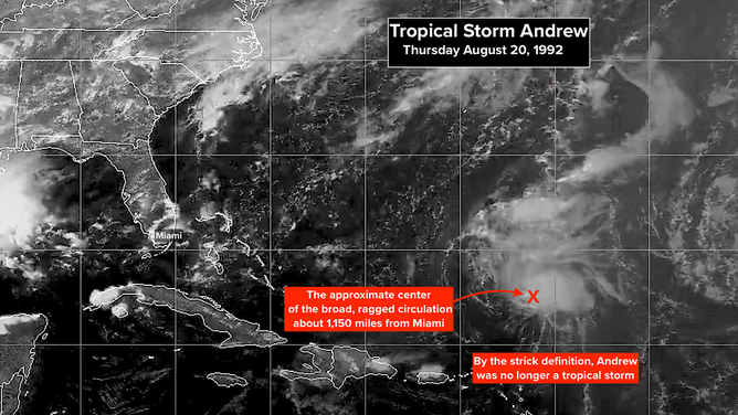
On this day 32 years ago, Tropical Storm Andrew was giving us a head fake.
(NOAA)
Hostile upper-level winds were tearing at the storm. The afternoon satellite showed a cluster of thunderstorms, but otherwise, dry air was infiltrating the system, and lines of clouds went every which way. The estimated center was about 1,150 miles from Miami.
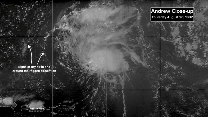
The afternoon satellite showed a cluster of thunderstorms, but otherwise, dry air was infiltrating the system, and lines of clouds went every which way.
(NOAA)
In the pre-internet days, the National Hurricane Center produced a short text product called an "Intergovernmental Discussion" each forecast cycle written by the hurricane specialist on duty. It provided people with access to the NHC feed, which came via a huge, clanking teletype printer, an understanding of the forecaster's thinking. (Today's "Forecast Discussion" product is more detailed because there's more data to analyze and discuss, and it's available to the public.")
That Thursday in 1992, veteran forecaster Hal Gerrish was on the day shift monitoring Andrew. In the 5:00 PM discussion, he acknowledged that Hurricane Hunters (recon stands for reconnaissance aircraft) had tried all day to find the center of circulation, but they had no luck. Procedurally at that time, a system without a defined circulation would get downgraded to just a disturbance, the name would be removed, and NHC advisories would be discontinued until the circulation reconstituted itself, if it ever did.
In this case, however, the recon found strong winds only 1,500 feet above the ocean (60 knots = about 70 mph), and the system was close to land. Legendary National Hurricane Center Director Bob Sheets made the break-the-rules decision to continue to call the system Tropical Storm Andrew in case it reorganized soon. He wanted to maintain public awareness of the potential threat.
Here is Hurricane Specialist Hal Gerrish's Intergovernmental Discussion written that Thursday afternoon.
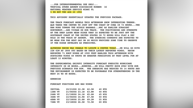
Here is Hurricane Specialist Hal Gerrish's Intergovernmental Discussion written that Thursday afternoon.
(NOAA)
Notice that the first paragraph is about the various computer forecast models. They were aiming from Cuba to the Carolinas. The reference to the "NHC as earlier straight northwest" is about the NHC90, considered the most reliable model at that time. Here are the spaghetti plots showing the key models forecaster Gerrish was considering to make the forecast.
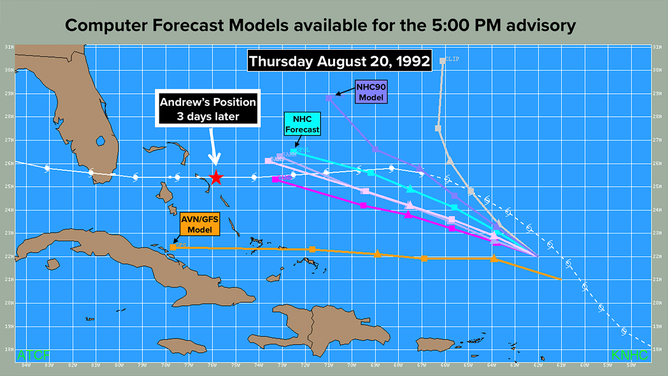
A look at the various computer forecast models.
(NOAA)
It's interesting that Gerrish forecast Andrew to stay farther south than the NHC90 prediction. (Much later, researchers discovered a bug in the data entered into the NHC90, which was goofing it up.) Maybe he had some of the same concerns I had about high pressure building across the Carolinas that might hold Andrew south. He mentioned that issue in previous discussions.
Notice the orange AVN/GFS model that goes to Cuba. It was called the AVN at the time, but was renamed the GFS in 2002. A more modern version is the model we use today. The hurricane tracker (spaghetti plot) was brand new in 1992. Forecasters had never seen the AVN plot before Andrew. It had no track record, so they ignored it early in the storm. Also, a new spaghetti plot for the AVN didn't come in until the evening, so they were always looking at an old version.
The AVN was ultimately the most accurate model because it picked up on Andrew's faster motion, but even if it had been considered, it wouldn't have been much help that Thursday afternoon since its track was way too far south.
In the end, the NHC forecast was too slow and too weak. At the bottom of the discussion, you can see that the 72 hour/3-day forecast wind speed was 60 knots (70 mph) - still a tropical storm. Three days later, it was Sunday afternoon. Hurricane Andrew had blown up by that time, was mauling Eleuthera in the Bahamas with 160 mph winds, and was aimed at South Florida.
The technology of the era was not good enough to deal with a fast-developing hurricane like Andrew. It went from a disheveled system to a Category 5 monster in 3 days. We have many more tools today to predict rapid intensification, but there's no guarantee. And getting people to evacuate or prepare is challenging when the system offshore is weak.
In the tropics today, nothing is cooking. Most macro factors are in place for an explosion of tropical activity, but fortunately, the large-scale flow in the atmosphere is moving disturbances off Africa unusually far north. They would have to take a more southerly route to avoid the dry air and hostile upper winds.
Ernesto is transitioning into a non-tropical system as it heads into the North Atlantic to die.
Bermuda's tourism folks want you to know they're still cleaning up, but the island is open for business. Although it took a direct hit from Hurricane Ernesto last Saturday, the infrastructure there is very strong. As expected, they are recovering quickly.