Bryan Norcross: Remembering Hurricane Andrew 3 days before landfall as the 2024 tropical Atlantic remains calm
Standard protocol called for removing the name until the system could reorganize itself, if it ever could. But National Hurricane Center Director Bob Sheets opted to keep calling the system Tropical Storm Andrew to minimize confusion if it pulled itself together and became a threat.

Bryan Norcross analyzes tropical activity in Pacific, lack of activity in Atlantic
FOX Weather Hurricane Specialist Bryan Norcross breaks down what the increase in tropical activity in the Pacific Ocean means for Hawaii while also explaining why there's a lull in activity in the Atlantic Ocean on Wednesday, Aug. 21, 2024.
Updated at 9:45 a.m. on Aug. 21, 2024.
On this day 32 years ago, Tropical Storm Andrew had recovered from its day-earlier discombobulation and was clearly organizing and slowly strengthening. If you recall yesterday's post, throughout Thursday, Aug. 20, Hurricane Hunters could not find an organized circulation in the system.
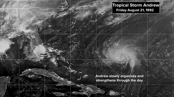
This satellite image shows Tropical Storm Andrew on Aug. 21, 1992.
Standard protocol called for removing the name until the system could reorganize itself, if it ever could. But National Hurricane Center Director Bob Sheets opted to keep calling the system Tropical Storm Andrew to minimize confusion if it pulled itself together and became a threat.
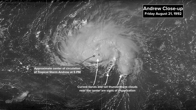
This is a close-up look at Tropical Storm Andrew on Aug. 21, 1992.
Close-up satellite pictures at 5 p.m. that Friday showed curved bands rotating into a center covered with high clouds. Thunderstorms were developing near the center of circulation. Hurricane hunters found the pressure in the storm was dropping, though it was still unusually high.
Legendary hurricane forecaster and later Hurricane Center Director Max Mayfield was working the day shift. In the Intergovernmental Discussion he wrote at 5:00 p.m., he noted that the increased organization would likely lead to strengthening. And interestingly, he referenced the NMC Aviation model - today we would call it the American GFS model – which showed a high pressure system (meteorologists call it a ridge) developing to the north of Andrew.
I had had that high pressure system in the back of my mind all week. If that high got too strong, it would block Andrew's turn to the north. Indeed, Max mentions a potential motion to the west, which meant Andrew could head toward somewhere in the southern half of the Florida Peninsula.
Here's the discussion that went out that afternoon. Remember, it was not available to the general public. It came into our weather office and government offices around the country on a teletype machine that sat in the corner. It was an old mechanical printer that came to life when bulletins arrived from the National Weather Service or the National Hurricane Center.
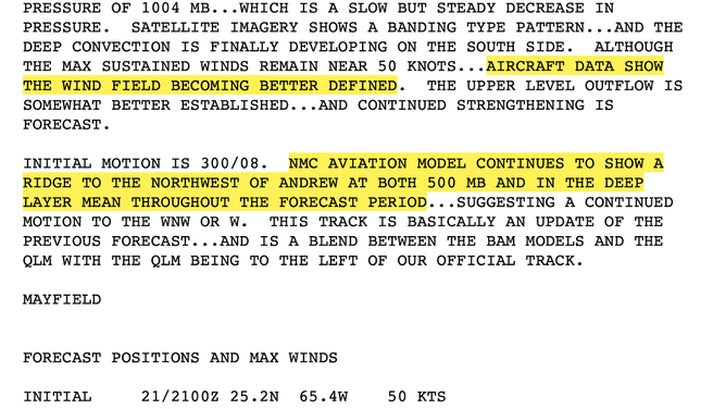
This was the discussion from the National Hurricane Center regarding Tropical Storm Andrew on Aug. 21, 1992.
Notice the 72-hour/3-day forecast at the very bottom of the text. The prediction was that Andrew would become a hurricane by Sunday, Aug. 23, and would continue strengthening into Monday afternoon of Aug. 24, with the storm located well northeast of the Bahamas at that time - far from Florida. Obviously, a very different scenario played out.
Here are the computer models that Max used to make the afternoon forecast.
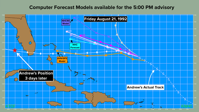
This graphic shos the computer forecast models for Tropical Storm Andrew on Aug. 21, 1992.
Notice where the official NHC forecast location is for Monday afternoon on the 24th - still well east of Florida. Now we know, of course, that by that afternoon, monster Hurricane Andrew had already devastated Homestead and the rest of southern Dade County.
In fairness to Max and the other terrific National Hurricane Center forecasters of the era, the computer models were not up to the task. The model the hurricane specialists had relied on most over the previous couple of years was the NHC90. As Andrew progressed, however, it was clear that the NHC90 was pointing too far north and that the brand-new AVN might have some merit. Its forecast was consistently farther south. In addition, the various BAMS models, which only considered the flow in one level of the atmosphere, were unfailingly south of the NHC90 as well.
Equally important, all of the computer forecasts were way too slow. Even the AVN/GFS, which had the track essentially correct, forecast a slow-moving storm just heading into the Bahamas on Monday afternoon, when in reality, Andrew had already crossed Florida and was in the Gulf.
We look at this data today and wonder how anybody could ever have made a forecast with this low-quality information. But our mentality was different back then. Nobody thought we could predict exactly where the storm was going to be 3 or 4 days in advance, let alone its strength.
A Hurricane Watch wasn't issued until about 36 hours before landfall at that time, and a Hurricane Warning came out about 24 hours before impact. That was if everything was on schedule and the storm didn't speed up.
People didn't take action on the "long-range" forecast. They waited for the Watch or the Warning. In the of Andrew, the NHC forecast 30 hours before Andrew hit turned out to be on target.
I couldn't access the spaghetti plots in the WTVJ Weather office in those pre-internet days. Instead, I waited for weather maps to come off a special printer that showed the overall weather pattern forecast by the AVN/GFS model. At about 3:30 PM that Friday, the map came in showing an even stronger blocking high-pressure system to the north of Andrew than had been forecast the day before. If that stronger high materialized, Andrew would track further south and move more quickly.
Since it was Friday at the end of the summer with school starting the following week, I thought people needed to be aware that a hurricane threat was possible that weekend. We blew up the newscast that afternoon and went into hurricane-threat awareness mode. My message was that we might have to prepare for a hurricane over the weekend, and everyone should be sure to stay informed.
I've been asked 1,000 times why I was the first to forecast that Hurricane Andrew was going to hit South Florida. In actuality, I wasn't forecasting anything except a potential threat. In those pre-cellphone days, people often tuned out over the weekend, were out on their boat, or just relaxing. The fact that it was the last pre-school weekend of summer just added to my inclination to "go early" with the messaging.
By 11 o'clock news time, all the TV stations were on board with the idea of a potential threat. We went to bed that night wondering what the weekend would bring, but with confidence we could handle it. The official forecast had Andrew slowly strengthening but tracking well north of Miami. But that blocking high-pressure system nagged at my mind, so I didn't sleep especially well.
THE 2024 TROPICS should stay quiet in the Atlantic for the next week, at least. The long-range computer forecasts indicate that we'll watch for development on our side of the Atlantic or in the Caribbean in early September. We'll see.
On the other hand, THE PACIFIC is going crazy. System after system is on an unusual storm track in the general direction of Hawaii. The ocean is on the cool side around the Hawaiian Islands, so the systems should not be terribly strong, but could still have impacts. If the first one organizes, it will be called Hector. It's due to reach the Big Island early next week.