Bryan Norcross: Remembering Hurricane Andrew 2 days before catastrophe as 2024 tropical Atlantic stays quiet
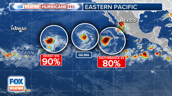
In the Pacific, a disturbance officially called Invest 91E is on the cusp of organizing into a tropical depression or a tropical storm. The storm is likely to impact the Hawaiian Islands early next week. The system will encounter a dry atmosphere and cooler ocean water as it approaches Hawaii, so a hurricane is unlikely, and the storm will probably slowly weaken as it passes the islands.

FOX Weather is your Hurricane HQ.
(FOX Weather)
Updated at 10:30 a.m. ET on Thursday, Aug. 22, 2024
On this day 32 years ago, Andrew became a hurricane - the first named storm and the first hurricane of the 1992 season. Hurricane Hunters flying through the storm overnight found strong winds north and south of the center, so the National Hurricane Center officially upgraded Andrew to a hurricane at 5:00 AM ET.
Hurricane specialist Lixion Avila was on the overnight shift at the forecast desk. When the aircraft reported hurricane-force winds and dropping central pressure, he called NHC Director Dr. Bob Sheets at home at about 4:00 AM. Bob said to make it Hurricane Andrew, hold off on any watches, and that he would be there soon. Bob arrived at the Hurricane Center in Coral Gables about 6:00 AM and ran the operation magnificently throughout the day, including writing the critical advisories and discussions himself.
I was up early and turned on the TV to see what had happened overnight. One look at the satellite picture and I thought, "holy crap." Andrew was just a Category 1, but I could see it beginning to turn west, and it was clearly organizing, which meant it would strengthen. That blocking high-pressure system to the north that I had been thinking about all week was coming into play.
Here is the view from the GOES-7 satellite after the sun came up that Saturday morning.
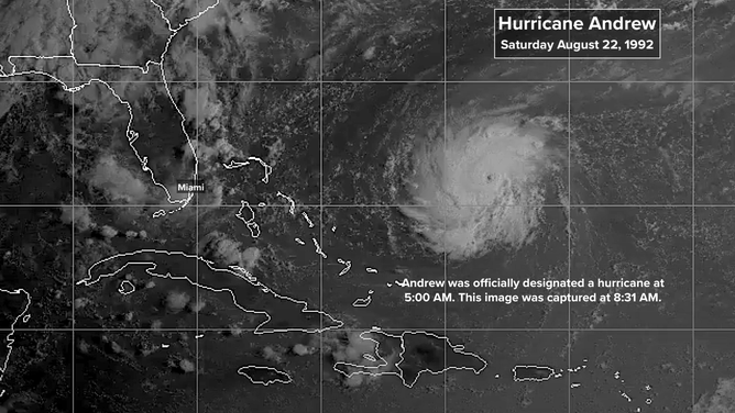
(NOAA)
In those pre-internet days, I couldn't look at data or read the forecaster's discussions at home. I had to call the National Hurricane Center to find out what was going on beyond what I saw on the TV news. I don't remember who I talked to, but the message was, "It's bad." Florida was going to get hit, and maybe hit hard.
I got ready as fast as I could and ran to the WTVJ studios in downtown Miami. I went on the air at noon and stayed on for most of the day. The part of the broadcasting I remember most was standing in front of a graphic showing a phone number that people could call and ask questions on the air. The phone lines were jammed. I stood there for hours. We did almost nothing except answer questions that afternoon with our news crews occasionally reporting in.
At 5:00 AM that Saturday morning, the official NHC forecast had aimed the storm toward Central or North Florida. By 11:00 AM, the computer forecast models and the official forecast shifted south to near the Palm Beach/Martin County line, about 75 miles north of Miami.
The afternoon computer forecasts continued to shift south, and the NHC forecast written by Dr. Bob Sheets followed suit at 5:00 PM. Landfall was explicitly forecast near Boca Raton, but in the same advisory, a Hurricane Watch was issued for more than 200 miles of the Florida east coast plus the Florida Keys. The extent of the hurricane watch from Titusville to Key West and the Dry Tortugas shows how much uncertainty the NHC forecasters knew was baked into their prediction.
Here is the discussion Dr. Sheets wrote explaining his thinking behind the 5:00 PM forecast. Notice that he wants everybody to be aware of the uncertainty as conveyed by the size of the Hurricane Watch area and not to focus on the exact track. A message that is still difficult to convey 32 years later.
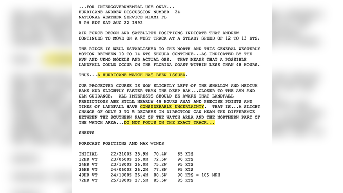
(NHC)
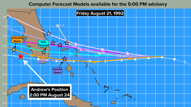
And also below are the key models Bob and his team of hurricane specialists were looking at that afternoon. Notice that the NHC90 and the AVN/GFS both shifted to south to near Miami. For the NHC90, that was a massive change. In the morning, it was aimed at Palm Beach County, about 80 miles farther north. Now that we know the track Andrew took, we can see that the NHC90 had the right idea, but it was too slow. While the AVN/GFS was a good forecast as well, but it was too fast.
(NOAA)
Bob swung the official forecast south in response to the model predictions. Then as now, the National Hurricane Center doesn't "follow the models." We've all seen the computer forecasts swing one way in the morning and the other in the afternoon. The NHC aims for consistency along with accuracy, so they only incrementally move the forecast until the models settle in, which they did later that night.
It was clear from the satellite image we saw at 5:30 PM that afternoon. Andrew was growing into a monster, and it kept leaning west. I could see that the forecast was going to shift even farther south.
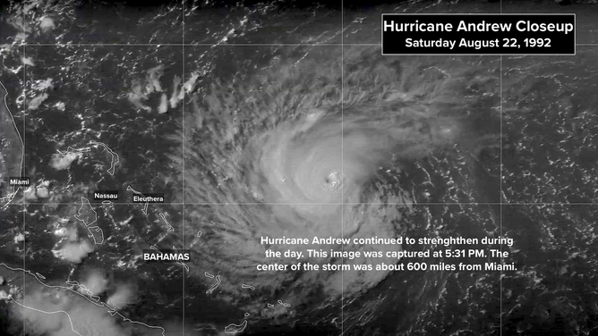
(NOAA)
And so began South Florida's first big hurricane threat since 1979. By the 11 o'clock news that night, just about everybody had the word. Sunday would be our only day to prepare and to position ourselves for a hurricane hit that was now forecast for Monday morning.
The forecast had again shifted south in line with the NHC90 and AVN/GFS computer predictions. The track was aimed at Dade County, south of downtown Miami. The forecast intensity at landfall was Category 3. Hurricane specialist Miles Lawrence wrote the advisory at 11:00 PM. He noted that the storm's intensity "could go even higher before affecting land." And so it did.
Even today, people tell me they heard that Hurricane Andrew was supposed to hit at the Dade/Broward line between Miami and Fort Lauderdale. I don’t know where that message came from. It was never the explicit National Hurricane Center forecast. But the precise forecast landfall point was only a guess anyway. All of South Florida was at risk. And there was only one day to prepare.
We were still on the air with WTVJ's 11 o'clock news at 1:00 AM. At about 1:15 AM, I told the crew we had to stop. We had to get ready for Sunday. On TV I said, "Friends... I'm going to go home now and get some sleep because tomorrow is going to be a big day in the history of our city and South Florida. I suggest you do too, because we might not get to sleep tomorrow night." And we didn't.
The 2024 tropical Atlantic is still calm. Systems exiting Africa are plowing into thick Saharan dust. Nothing is expected to develop in the next week. Long-range computer projections show development possibilities increasing around the beginning of September.
In the Pacific, a disturbance officially called Invest 91E is on the cusp of organizing into a tropical depression or a tropical storm. The storm is likely to impact the Hawaiian Islands early next week. The system will encounter a dry atmosphere and cooler ocean water as it approaches Hawaii, so a hurricane is unlikely, and the storm will probably slowly weaken as it passes the islands.
(FOX Weather)
The biggest effects should be a gusty tropical moisture surge on the windward sides of the islands, especially the Big Island and Maui. Torrential rains are possible. Stay informed in the impacted areas. The system hasn’t developed yet, and forecast adjustments are possible.