Bryan Norcross: Remembering Hurricane Andrew on last day before landfall while 2024 tropical Atlantic is quiet
The 2024 tropical Atlantic remains amazingly calm. There’s no indication of any potential threats for the rest of August, at least.

Hurricane Andrew: 32 years later after Category 5 storm tore through South Florida
FOX Weather Hurricane Specialist Bryan Norcross joins Weather Command to look back at Hurricane Andrew. It was one for the record books, devastating South Florida as a Category 5 hurricane.
Updated at 9:30 a.m. ET on Friday, Aug. 23, 2024
On this day 32 years ago, South Florida was in full hurricane preparation mode. It was surreal. Hurricanes had not been a part of life for decades. When June 1 came each year, it was a yawner — hurricane season, haha!
Hurricane David brushed the area by moving offshore in 1979, but it had been 27 years since a strong hurricane threatened Greater Miami from the east. Hurricane Betsy ended up tracking over the Upper Florida Keys, but the expansive winds pushed storm surge over Miami Beach. Huge waves broke through the windows of fancy oceanfront hotels. A quarter of the animals at the Miami Zoo on Key Biscayne died in their cages as ocean water swamped the island.
After three big hurricane hits in the 60s and other scares, Mother Nature turned off the hurricane spigot that had been dousing South Florida with big storms since the first decade of the 20th century. But now, Andrew was a reality.
Some old timers were a little slow to come around because there was an old-school Miami hurricane rule that any time a storm tracked north of Miami's latitude (which Andrew did), we were in the clear. In other words, storms didn't bend to the south, they only arced north. That's true, of course, except when it's not.
Some South Florida residents still hadn't gotten the word that a mega hurricane was coming by that Sunday morning. But by evening, South Florida was calm. People were where they thought they should be to ride out the storm, while they waited and wondered what the night would bring.
When the sun rose that morning, the view from the satellite was stunning. Andrew looked like a hurricane graphic, not a real storm. This image is from the NOAA-12 satellite, which had special high-resolution capabilities. Looking at it today, you can get a good idea of what we were facing - Mother Nature at her most magnificent and threatening.
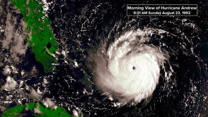
(NOAA)
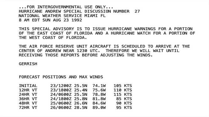
The National Hurricane Center issued a special advisory at 8 a.m. to issue a Hurricane Warning for the southern coast of the Florida Peninsula and Florida Keys. The warning zone extended all the way north to Vero Beach, acknowledging the uncertainty in 1992 forecasts even a day before landfall. Here is the special Intergovernmental Discussion written by hurricane specialist (and later NHC director) Max Mayfield.
(NOAA)
When the aircraft reported in, the data was surprising, but it wasn't. The pressure was plummeting, but the satellite images were so stunning that we knew Andrew was quickly intensifying. Top winds were up to Category 4 at 11:00 AM.
Grocery store shelves were bare of anything that could be considered a hurricane supply. There was some negative energy when stores ran out of plywood to cover windows, but generally, everybody went about their business with stunned, good nature.
I got to WTVJ's studios and downtown Miami at 8 a.m. after dealing with the shutters on my house. After much discussion and concern for our news crews, I sat down at the anchor desk at 9 a.m., knowing my shift was likely to run through the night.
The National Hurricane Center forecast was steady into Dade County south of downtown Miami. But through that Sunday, I thought the odds were just as high that it was going to Fort Lauderdale as Miami, Homestead, or the Keys. My message was that all of South Florida needed to prepare.
Evacuations were ordered for the beach communities and low-lying areas. Many people left. Traffic was slow but steady on all roads north. Though many people stayed as well. Nobody could imagine ocean and bay water sweeping across the barrier islands and through the city. I could imagine it because I had studied Miami hurricanes of the past.
That afternoon, we watched Andrew peaked in intensity as it approached the Bahamas. The modern estimate is that the top winds were sustained at 160 mph when the eye of the hurricane crossed the northern tip of Eleuthera Island.
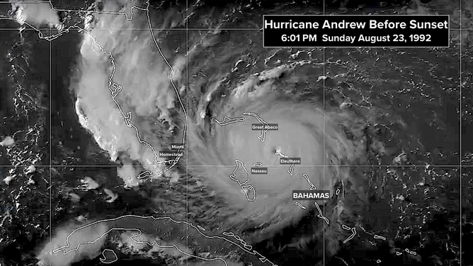
Andrew peaked in intensity as it approached the Bahamas.
(NOAA)
The computer forecast models available to the National Hurricane Center for the 5 p.m. advisory showed an overwhelming consensus that Andrew was coming to South Florida. The AVN model (called the GFS today) was too far south and too fast. The rest of the models, including the NHC90, which was making terrible predictions in previous days, were all zeroed in on Dade County, though a bit too slow.
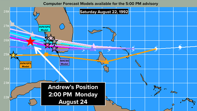
The computer forecast models available to the National Hurricane Center for the 5 p.m. advisory showed an overwhelming consensus that Andrew was coming to South Florida.
(NOAA)
By evening, the possible became probable and eventually inevitable. A worst-case scenario was going to happen that night. The only question was, what part of South Florida was going to suffer the most?
By midnight, the eye of Hurricane Andrew was fully within range of the Miami National Weather Service radar. The venerable WSR-57 radar was located on top of the building housing the National Hurricane Center in Coral Gables, just south of downtown Miami. Looking at the radar image today, it's scarier than I remember feeling that night.
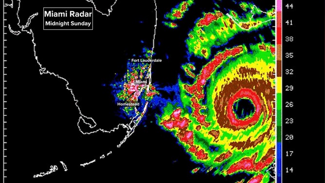
By midnight, the eye of Hurricane Andrew was fully within range of the Miami National Weather Service radar.
(NOAA)
Will it wobble north? Or south? Where will the corridor of strongest winds rip across South Florida? How can people stay safe in the face of a storm like this? These were the questions that echoed in our minds as Sunday night became Monday morning, August 24, 1992.
The 2024 tropical Atlantic remains amazingly calm. The disturbances coming off Africa are robust, and we would normally have to watch them closely. But they are tracking far enough north to immediately get entangled with Saharan dust, so they barely survive the trek west. There’s no indication of any potential threats for the rest of August, at least.
In the Pacific, Tropical Storm Hone is heading toward Hawaii. The center is likely to track south of the islands, but thick tropical moisture will cause heavy rain and potential mudslides and flooding on the windward side of the Big Island beginning tomorrow.
The heaviest rain will likely fall on the mauka areas (what Hawaiian's call the area uphill from a road across the mountain) on the windward slopes. Rainfall of 4 to 8 inches along with winds strong enough to take out power are forecast on the east side of the Big Island with lesser amounts but still significant rainfall on the smaller islands to the west.
Impacts begin around midday Saturday Hawaii time on the Big Island and spread to the other islands into early next week. Stay in touch with the latest information and instructions from emergency officials in the islands.