Bryan Norcross: Remembering Hurricane Andrew as it threatened Louisiana as 2024 tropical Atlantic stays quiet
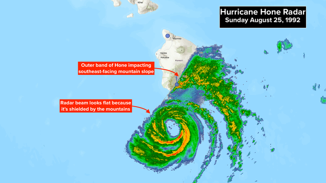
Now in 2024, the tropical Atlantic remains bizarrely quiet. Long-range computer forecasts hint at some activity around the first of September. We'll see. Near Hawaii, Hone has intensified into a hurricane. The center of circulation is about 50 miles south of the southern tip of the Big Island, far enough away to keep the worst weather offshore. A strong outer band is causing extremely heavy rain and strong winds on the southeast slopes of the mountainous terrain, however.

FOX Weather is your Hurricane HQ.
(FOX Weather)
Updated at 9 a.m. ET on Sunday, Aug. 25, 2024
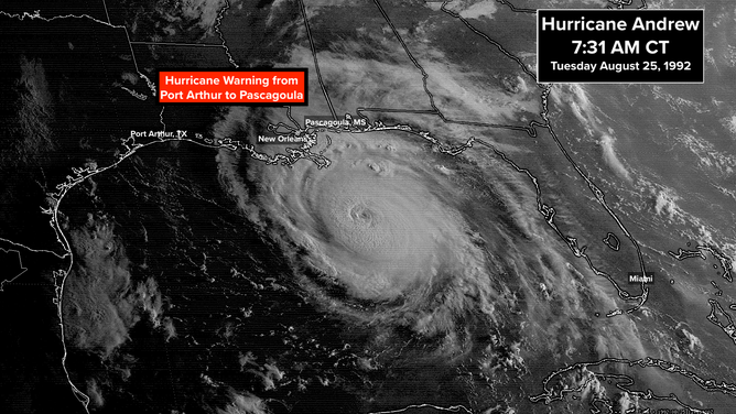
On this day 32 years ago, Hurricane Andrew was at Category 4 strength, showed signs of strengthening, and was aiming at southeastern Louisiana. The National Hurricane Center extended the Hurricane Warning to include the entire Louisiana and most of the Mississippi coast. Metro New Orleans was on alert. The storm that had ripped across South Florida was forecast to tiptoe onto the northern Gulf coast. Exactly where was the big question.
The previous evening, Andrew seemed to have New Orleans in its crosshairs, but as it approached Louisiana, the forecast became more uncertain. The computer models that Tuesday morning aimed farther west.
One of the miracles that morning was that the National Hurricane Center was still issuing forecasts. Operations in Coral Gables were being held together with little more than determination. Satellite dishes had blown away, many of the communication links were down, but a lifeline to the National Weather Service headquarters near Washington stayed up.
Most of the NHC staff had damaged or destroyed homes to deal with. But they never missed an advisory, even as the computers overheated from lack of A/C and the future of their community looked uncertain. It was an inspiring and heroic display of dedication.
This was the view of Andrew from space early that Tuesday. The modern estimate is that top winds were 140 mph. The eye was filled with clouds, an indication that the old eye of the storm was decaying and a new one was forming. Strengthening often follows that process.
(NOAA)
In the late morning NHC advisory, Hurricane Warnings were extended west to Galveston Bay. Such was the uncertainty due to the storm's constant tendency to lean to the west of the forecast track. No doubt Andrew's insistence on staying left as it approached Florida was in forecasters' minds.
A storm surge of 10 to 15 feet above the normal tide was predicted for some part of the coast, depending on where the storm finally made landfall.
Hurricane-force winds lashed the coast but didn't extend very far inland. Andrew was teasing Louisiana.
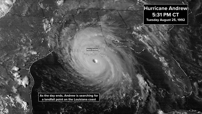
By late afternoon, the center of circulation was 125 miles south of New Orleans. The new 35-mile-wide eye had fully formed. Andrew looked fierce. Modern estimates are the top winds were 145 mph.
(NOAA)
The last thing people in southern Louisiana heard when they went to bed that night, if they slept at all, was that "little change in intensity [was] expected before landfall." It was a scary night with a giant Category 4 hurricane offshore, drifting toward somewhere on the coast.
Meanwhile, in South Dade County, Florida, the situation was deteriorating. After Andrew hit early the day before, the weather cleared. People slept wherever they found a dry spot out of exhaustion from the ordeal of the morning. But now, reality was setting in.
There was no power, no water, little if any communications. People that were lucky had a working landline phone in the neighborhood.
It was clear by that Tuesday night that there was no obvious answer to the monumental questions. How and where do hundreds of thousands of people who lost their homes and livelihoods eat and sleep? What's supposed to happen next? There was no playbook, and nobody knew.
A miracle of Hurricane Andrew is that most people who lived in South Dade survived... and eventually thrived.
Now in 2024
The tropical Atlantic remains bizarrely quiet. Long-range computer forecasts hint at some activity around the first of September. We'll see.
Near Hawaii, Hone has intensified into a hurricane. The center of circulation is about 50 miles south of the southern tip of the Big Island, far enough away to keep the worst weather offshore. A strong outer band is causing extremely heavy rain and strong winds on the southeast slopes of the mountainous terrain, however.
(NOAA)
Hone will continue to bring periods of rain and some gusty winds to the higher elevations of the islands as it tracks west well south of the Hawaiian chain over the next couple of days.
Hurricane Gilma is heading in the direction of Hawaii as well but is on a more northern track over colder water. A weak version of the system might have some effect on the Big Island late this week.