Bryan Norcross: Remembering Hurricane Andrew on Louisiana landfall day; 2024 tropical Atlantic takes break
THE 2024 tropical Atlantic is stunningly calm for late August. No development is expected this week. In the Pacific, Tropical Storm Hone is now passing well south of the Hawaiian Islands.

FOX Weather is your Hurricane HQ.
(FOX Weather)
Updated at 9:15 a.m. on Monday, Aug. 26, 2024.
On this day 32 years ago, Hurricane Andrew made its final landfall. After skirting the Louisiana coast for a few hours after midnight, the modern analysis is that landfall occurred about 3:30 a.m. CT over a spit of marshy land called Point Chevreuil, 20 miles southwest of Morgan City.
Nerves were rattled the morning before when it looked like a hit on metro New Orleans might be a Louisiana version of Andrew's horrendous attack on South Florida. In the end, the center of circulation crossed out of the Gulf of Mexico onto the swampland of southern Louisiana about 90 miles west of the Big Easy. Winds in the city gusted to 66 mph at the airport.
The relatively new National Weather Service radar over 200 miles away in metro Houston captured the moment of landfall. The blocky look to the eye was because the radar was so far away. The WSR-88D (WSR meaning 'Weather Service Radar,' '88' meaning originally 1988 technology, and 'D' meaning digital) NEXRAD network was still being deployed in the early 1990s. The location labeled P92 on the map is Salt Point, Louisiana, just up the coast from Point Chevreuil.
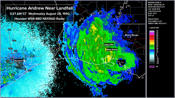
This image shows the radar as Hurricane Andrew made landfall in Louisiana.
Because the radar was far to the west, only half the storm is visible on the Houston image. The old WSR-57 (yes, '57' means 1957 technology with improvements along the way) captured the landfall and the eastern half of Andrew's circulation. We're left with this fuzzy image, but you can see the brightest colors rotating across the Morgan City area with a strong outer band pushing toward metro New Orleans.
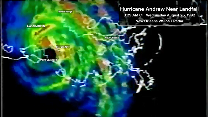
This image shows the radar as Hurricane Andrew made landfall in Louisiana.
The data reanalysis project undertaken by NOAA and the National Hurricane Center for the 10th anniversary of Andrew's landfall estimated that the top winds had weakened to about 115 mph (Category 3) at landfall, but the storm was only moving about 9 mph. Damage was extensive from southeastern Louisiana into Mississippi.
Perhaps because people saw what occurred in South Florida two days before, residents largely followed the evacuation orders. In the end, over 20,000 homes were damaged. Forty-some tornadoes in Louisiana and Mississippi added to the misery. The strongest was in La Place, Louisiana, northwest of New Orleans, where 2 people died and over 150 homes and businesses were damaged or destroyed.
Along the Louisiana coast, the barrier islands took a major beating, and Louisiana's precious fishing industry took a hard hit. Offshore, over 200 oil platforms were damaged.
By afternoon that Wednesday, Andrew was downgraded to a tropical storm as it crossed into southwestern Mississippi, and overnight it was down to a tropical depression. Andrew's rampage was finally over, although heavy rain continued to fall as the storm's remnants arced to the northeast.
The last official trace of the Great Hurricane of 1992 was over Great Smoky Mountains National Park in western North Carolina.
Because of the cataclysmic events in South Florida, Hurricane Andrew's impact in Louisiana is often overlooked. It alone was more than a billion-dollar disaster, however. And for the thousands of people who lost their homes, it was a life-changing event.
Lessons galore came out of Hurricane Andrew's assault on South Florida and Louisiana. One I mentioned in a previous post - "The worst does happen." An expanded version of that thought is, "Most often you will over-prepare because the odds are that the worst of the hurricane is NOT going to hit you – except when it does."
Another is less a lesson than a reminder. "The four strongest storms on record to hit the United States were all tropical storms 3 days before landfall."
Evacuations and preparation are undertaken based on what reasonably COULD happen. Both are inconvenient, but living along the coast means living with hurricanes. There is nothing to do but to have a hurricane plan and be ready to implement it when the inevitable hurricane heads in your direction."
The 2024 tropical Atlantic is stunningly calm for late August. No development is expected this week.
The macro factors we normally look at are still in place that normally support more frequent and stronger-than-average hurricanes. But other factors are out of whack. More on that tomorrow.
In the Pacific, Tropical Storm Hone is now passing well south of the Hawaiian Islands. Some fringe effects will be felt on the islands today. Hone should weaken into a moisture blob in the central Pacific in a few days.
Hurricane Gilma and Tropical Storm Hector are heading in the general direction of Hawaii. Neither are expected have any significant effect on the islands. Cooler waters and hostile upper winds should kill off both systems.