Bryan Norcross: A potential disturbance to watch and what's going on with hurricane season 2024?
A potential disturbance in the Atlantic is forecast to take a more southerly track than the African disturbances we've seen so far this August, which could give it a chance of getting past the persistent Saharan dust.

FOX Weather is your Hurricane HQ.
(FOX Weather)
Updated at 9 a.m. ET on Tuesday, Aug. 27, 2024.
Long-range computer forecast models are showing the possibility of a system developing and moving toward the Caribbean over the weekend or early next week. The system is forecast to take a more southerly track than the African disturbances we've seen so far this August, which could give it a chance of getting past the persistent Saharan dust.
There's nothing much to look at yet. I’ve outlined a cluster of clouds that seem to be in the vicinity of the weak disturbance the computer forecasts are picking up on.
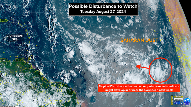
Norcross outlined a cluster of clouds that seem to be in the vicinity of the weak disturbance.
(NOAA)
If the disturbance ducks under the dust and makes it to the vicinity of the Caribbean islands, it appears the pattern will be more conducive for development, but that could take more than 7 days. That’s beyond the period that the National Hurricane Center’s forecast covers. For now, development chances are in the low category.
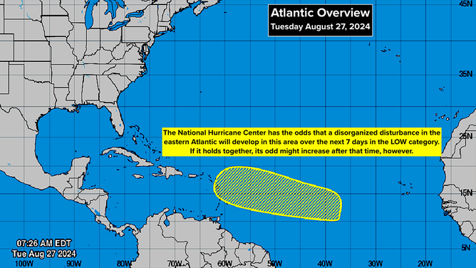
Development chances are in the low category.
(NOAA)
Looking at the bigger picture, everybody is asking, "What's going on with this hurricane season?" Well, it's been an above-average season so far in terms of the number of hurricanes and Category 3-plus storms. The number of named storms is on schedule, but we will fall behind on Friday if nothing forms. And nothing is expected by then.
The issue is, of course, that the strong consensus of the hurricane season forecasts made by agencies worldwide was that this would be a rip-roaring season. Many forecast groups predicted that records would be set. Clearly, something is going on, or more likely, some things are going on that are different from what was anticipated.
The short answer to the question of what's going on with hurricane season 2024 is that we don't know for sure. Is there some overriding macro factor that is suppressing activity? Or is it a combination of multiple independent meteorological and oceanographic features working together to inhibit development? Most likely, the second scenario is occurring. But whether it's a random occurrence, or the pattern or patterns are being driven by unusual or unique large-scale factors is probably unknowable at this point.
Hurricane season can be loosely divided into three parts. Early in the year, storms most often form near the Caribbean islands, Florida, or in the Gulf of Mexico. (Beryl was an extreme exception.) In August and September, most storms form from disturbances coming off Africa. Then late in the year, the focus is back on the western Caribbean, Gulf, and again near Florida.
If the African disturbance machine is shut down during the middle of the season, as it has been lately, we're not going to get as many systems moving west where they can develop. The mechanisms that are stopping the disturbances this year only have to let up a little bit for significant storms to form.
The five most consequential storms of the super-busy hurricane season of 2005 all formed in the western Atlantic. Katrina, for example, formed just east of the Bahamas. That doesn't mean the same thing will happen this year, but that's a lesson worth remembering.
There are some obvious factors that are keeping African systems from organizing and strengthening as they move across the Atlantic. The disturbances are leaving Africa farther north than normal, so they are running slam into Saharan dust, which is thicker than average for this time of year. Also, the ocean water off Africa at that northern latitude is a lot colder than just a bit south. It is an open question whether all those factors are caused by a random displacement of the typical Atlantic high-pressure system or something else is driving northern storm track.
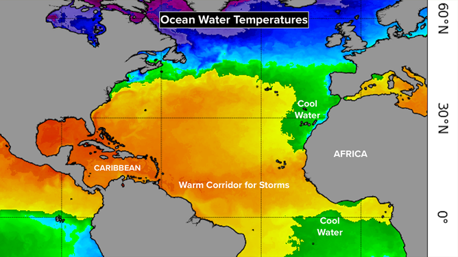
The ocean water off Africa at that northern latitude is a lot colder than just a bit south.
(NOAA)
If the African train of disturbances was to shift back south to a normal position, both of those negative factors would be eliminated, and systems would likely develop over the very warm ocean waters.
Also, the upper atmosphere over the Atlantic is unusually warm, which means there's less of a contrast between the ocean and the air loft. It's that contrast that builds thunderstorms. This factor wouldn’t likely prohibit development, but it could slow it slightly.
And there are some other factors that might or might not be involved.
There is an area of cold-than-normal water along the equator off the coast of Africa. This phenomenon, which has been called an Atlantic Niña, has been correlated with fewer storms forming in the far eastern Atlantic. That might be related to the displaced storm track over Africa or the suppressed formation of systems once they are over the ocean.
And remember the polar vortex? During our summer months, there is a polar vortex over the South Pole. It's been extremely active this season, altering how the jet stream flows. Extreme heat and cold have affected Australia and South America. There may or may not be a direct impact on the Atlantic hurricane season. Clearly, the entire atmosphere and ocean are connected, so it's a reasonable thought.
Then there are a couple of overriding factors that could be affecting all or some of these atmospheric and oceanographic features. In January 2022, the Hunga Tonga-Hunga Ha'apai volcano exploded under the South Pacific, propelling vast amounts of water high in the atmosphere. Some research has indicated that the extreme level of water vapor high above the earth's surface is disrupting the atmosphere's normal temperature distribution and weather patterns on the surface.
In addition, the earth's atmospheric and oceanographic system is warmer than it's been in many thousands of years due to global warming. A warmer ocean and atmosphere will behave differently than they would have without all the extra energy.
Whatever is driving the current weather pattern, the odds still favor hurricanes developing in September and October, intensifying more quickly than average due to the warm ocean, and ending up stronger.
The odds are that we won't see the off-the-charts number of named storms discussed earlier in the season, but the more important number is how many hurricanes develop. We have already had 3 and seeing another 6 - 10 given the extremely warm Atlantic water is still not out of the realm of possibility.