Bryan Norcross: Disturbance to watch as tropical Atlantic shows some signs of life
Long-range computer forecasts indicate that another system yet to come off Africa could also develop.

Why has Atlantic been so quiet despite talk of hyperactive hurricane season
Even with the potential developments in the Atlantic right now, one question remains on top of everyone's mind. Why has the Atlantic been so quiet despite all this talk of a hyperactive hurricane season? FOX Weather Hurricane Specialist Bryan Norcross helps answer that question.
Updated at 10 a.m. on Wednesday, Aug. 28, 2024.
The National Hurricane Center is painting an area near and east of the Caribbean islands where a tropical depression or tropical storm could form over the weekend or next week.
We're calling this system Potential Disturbance 2. The NHC is keeping the odds in the low category because the computer forecast models show a wide range of possibilities, and some don't show development until beyond the NHC's forecast window of seven days.
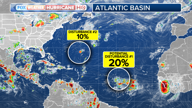
This graphic shows the areas to watch in the tropical Atlantic Ocean on Wednesday, Aug. 28, 2024.
(FOX Weather)
There's also Tropical Disturbance 1, which is a tiny system near Bermuda. It has a very slight chance of briefly developing. It's of no concern.
Potential Disturbance 2 has managed to duck far enough south to partially avoid the plume of Saharan Dust that has been sucking the moisture out of disturbances this season. One of the uncertainties involved continues to be whether the system can pull enough moisture from the south to fully counteract the dust plume to the north.
The system is part of an elongated semi-permanent area of showers and thunderstorms in the tropics. It will have to independently organize to pull itself free and lift north. Whether it can do that is an open question.

This satellite image shows the tropical Atlantic Ocean on Wednesday, Aug. 28, 2024.
(NOAA)
The steering currents over the tropical Atlantic are very light, so it's going to take several days for the disturbance to reach the islands. On the current schedule, that would happen Monday or Tuesday. Many of the computer forecasts show nothing more than a weak moisture surge passing over the islands, while others show a developed system. If the system can hang together until it reaches the Caribbean, the weather pattern could be conducive to organization and strengthening after that time.
Long-range computer forecasts indicate that another system yet to come off Africa could also develop. We'll see.
These African disturbances might be on a path that's far enough south, so they aren't running over cool water and plowing into the heart of the dust cloud. But the computer forecasts would be more bullish if the overall weather pattern was fully supportive of development. As I discussed yesterday, it's likely there are multiple factors making the eastern Atlantic inhospitable.
The eastern Atlantic shutdown has been so complete that African disturbances have been unable to break through to the Caribbean and farther west. We'll see if this slight opening is temporary or the beginning of a busier stretch. In any case, nothing is going to happen fast.