Odds of development increasing on the Atlantic tropical disturbance
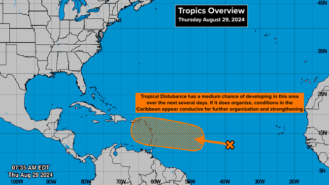
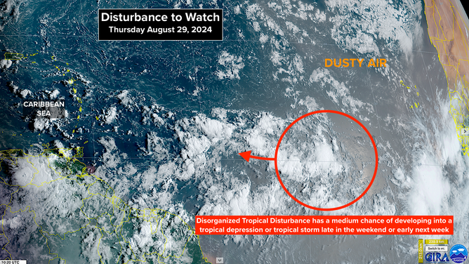
The National Hurricane Center is giving the Tropical Disturbance about midway between Africa and the Caribbean a medium chance of developing in the next 7 days. There is no identifiable center to track, so the computer forecasts have been inconsistent in their long-range projections. But now more of the predictions show the system gaining organization, and many show it strengthening in the Caribbean.

FOX Weather is your Hurricane HQ.
(FOX Weather)
Updated: Aug. 29, 2024 at 9:11 a.m.
The National Hurricane Center is giving the Tropical Disturbance about midway between Africa and the Caribbean a medium chance of developing in the next 7 days. There is no identifiable center to track, so the computer forecasts have been inconsistent in their long-range projections. But now more of the predictions show the system gaining organization, and many show it strengthening in the Caribbean.
The disturbance is moving more slowly than many systems we track through the tropical Atlantic, so it's going to take through the weekend before it approaches the Caribbean. Some computer forecasts still show the system moving through the islands as a gusty moisture surge, but some now show it developing into an organized tropical depression or tropical storm.
A tropical disturbance is seen in the Atlantic.
(FOX Weather)
Until the disturbance gains some organization so a center can be tracked, forecasts will be uncertain. Everyone in the eastern and northeastern Caribbean should prepare to stay informed over the weekend.
If the system can organize to a reasonable degree over the next several days, the atmosphere pattern near the islands and through the Caribbean appears conducive to development. A significant tropical storm or hurricane could develop.
The issue this season has been that the eastern Atlantic has been so hostile that robust disturbances moving off Africa have been squashed before they could reach the more conducive pattern in the Caribbean and western Atlantic.
A tropical disturbance in the Atlantic is seen amid dusty air in the basin.
(FOX Weather)
We have a lot of the hurricane season to go, so good sense says that we shouldn't make any assumptions about the future except that we have to stay vigilant. Don't assume that Mother Nature's August snooze means anything about the rest of the season.
IN THE GULF, the southeast Texas and Louisiana coast are in for an extended period of rain. The weather system involved is in the upper atmosphere, so it's not included as a potential development area. Still, from metro Houston to New Orleans, stay in close touch with information and instructions in case flooding becomes an issue.
NEAR THE AFRICAN COAST, another system is about to move into the Atlantic. This one seems to be ducking under the plume of Saharan dust. Many computer forecast models show it developing over the next few days. None indicates it will be a threat, but we will watch to be sure.