Bryan Norcross: Tropical Storm Debby expected to form today and impact Florida then Georgia and the Carolinas
Tropical Storm Debby is forecast to form off the coast of Southwest Florida later today.

Tropical Storm Debby expected to become a hurricane before Florida landfall
The National Hurricane Center upgraded Tropical Depression 4 into Tropical Storm Debby on Saturday. The cyclone could strengthen into a Category 1 hurricane before landfall on Monday.
Updated Aug. 3, 2024, as of 12:05 p.m.
Tropical Storm Debby is forecast to form off the coast of Southwest Florida later today. The large system is already pulling thick, tropical moisture over the state, and Flood Watches have been issued by the National Weather Service. In addition, Hurricane Watches are in effect for the Big Bend of Florida between Tampa and Tallahassee, and other alerts cover the western and southwestern part of the Florida Peninsula including counties inland from the coast.
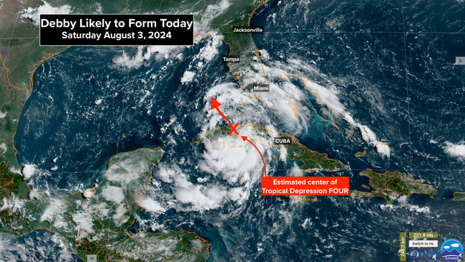
Debby likely to form today.
(CIRA / RAMMB / FOX Weather)
In areas where Storm Surge Warnings are issued, that means that SOMEWHERE in that zone the Gulf or bay water is expected to rise more than 3 feet higher than the normal high tide. Notice the emphasis on SOMEWHERE. In the counties well north and south of Tampa Bay, the storm surge forecasts are higher than that 3-foot threshold.
Because the location of the peak storm surge can vary dramatically with slight deviations in the angle of approach of the storm, Storm Surge Warnings always extend over a wider area than where the highest water ends up occurring. But if you're in a warning zone, listen carefully for information and instructions from your local public officials and emergency management office.
Remember, pay attention to any Tropical Storm or Storm Surge Warnings issued for your area, NOT the cone. Impacts from the storm will occur 100 miles outside of the cone.
On the current schedule, Tropical Storm Debby will form this afternoon and track to the north. Outer bands are already impacting South Florida. Waves of tropical rain will move north with likely-Debby.
There is high confidence that the center of likely-Debby Will track offshore of Tampa Bay tomorrow during the day and arrive at the Florida coast between Tampa and Tallahassee late tomorrow or in the early hours of Monday.
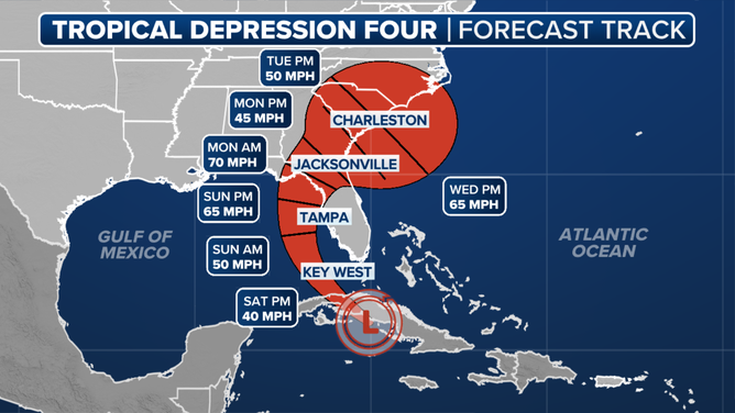
Tropical Depression Four Forecast Track
(FOX Forecast Center / FOX Weather)
After that, likely-Debby is forecast to slow its forward movement. The steering currents are predicted to collapse. There's a good chance of an EXTENDED period of heavy rain, strong wind, and potentially storm surge at the coast. Extreme impacts are possible in North Florida, southern Georgia, and in the Carolinas.
Impacts begin on the Gulf coast later today, with rounds of tropical downpours spreading up the Florida peninsula. Then Monday to perhaps Thursday dangerous weather is increasingly likely from North Florida to North Carolina. There is no way to predict exactly what will happen when the storm stalls or loops over or near the coast of Georgia or the Carolinas. But it's likely to be bad.
It's critical that everybody in the threat zones stays informed. The forecasts are likely to change over the next few days.