Bryan Norcross: Tropical Disturbance still not organizing but some computer forecasts still say it will
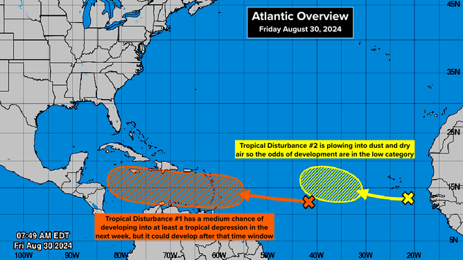
Tropical Disturbance No. 1 has as medium potential to develop into at least a tropical depression next week, according to the National Hurricane Center.

Bryan Norcross discusses future of tropical disturbances in Atlantic
FOX Weather Hurricane Specialist Bryan Norcross talks about the potential development of two tropical disturbances being watched in the Atlantic Ocean.
There are two tropical disturbances in the eastern Atlantic. Tropical Disturbance No. 1 is the one we've been watching to see if it can consolidate around a defined center of circulation. The National Hurricane Center has the odds in the medium range that it will develop into at least a tropical depression late in the weekend or next week as it tracks toward the Caribbean islands. If it's going to develop, it will more likely wait until it's in the Caribbean Sea.
ATLANTIC AWAKENS WITH 2 TROPICAL DISTURBANCES BEING TRACKED AS HURRICANE SEASON NEARS PEAK

Satellite imagery showing Tropical Disturbance No. 1.
The various computer forecast models give us a wide range of possible outcomes. There is a consensus that the disturbance will pass over the islands Monday or Tuesday. And the odds favor it being a gusty moisture surge instead of an organized system, but that's not 100%. As with any just-developing system, the forecasts are subject to change.
If it can attain some measure of organization by the time it gets to the Caribbean, the environment there could be conducive for significant development. While some long-range computer forecasts show the system becoming a hurricane and potentially affecting the U.S., many do not. The macro factors appear to be in place for a tropical system to develop, organize, and strengthen, but when a system is part of an elongated area of low pressure, the process of organizing is usually slow.
Since the system might very well wait to get to the western Caribbean to organize and strengthen, so we can't go to sleep on it even if it looks ratty into early next week.
In addition, there are other features in the atmosphere that could explain the system's slow development, with the emphasis on 'could.' The pulse that moves around the Earth alternately enhancing and suppressing tropical activity called the MJO, is in the suppression phase over the Atlantic at the moment. The current analysis is that the pulse isn't very strong, however, so normally we would think that the extremely warm ocean water and a conducive upper-level pattern would dominate the MJO's effects.
So for now, we watch and see what happens. Everybody on the northern and eastern Caribbean Islands should stay informed.
The National Hurricane Center is tracking two tropical disturbances in the Atlantic.
(FOX Weather)
Tropical Disturbance No. 2
Closer to Africa, Tropical Disturbance No. 2 is tracking west behind #1. The National Hurricane Center is giving it a low chance of developing into at least a tropical depression over the next week as it plows into a large patch of dust and dry air.
The steering currents are very weak, so the disturbance isn't going anywhere fast. There is always higher uncertainty in the track and development of systems that lollygag around, so we'll watch it. But there's no concern at the current time.
We are less than two weeks from the so-called peak of the hurricane season, of course. September 10 is the date when, averaged over 100 years, there is most likely to be a named storm in the Atlantic, Caribbean, or Gulf of Mexico. It's actually a little more complicated than that since we don't have great records from the years before there were modern satellites. In any case, it's clear the most active part of the season is the first two weeks of September.
That's looking at the Atlantic, Caribbean, and Gulf as a whole, however, and it's not true in Florida. October is essentially tied with September for hurricane hits. October storms tend to be less intense - though there have been glaring exceptions. Category 5 Hurricane Michael hit the Panama City area on October 10. And while Wilma was 'only' a Category 2 when it hit the Miami-Fort Lauderdale-West Palm Beach metropolitan area, with most areas receiving Cat 1 winds, it was the third most expensive hurricane in history at that time.