Bryan Norcross: Slow-developing Atlantic disturbance could be a U.S. threat if it organizes in the Caribbean
At this point, just be aware of a potential storm threat near Mexico's Yucatán Peninsula about next weekend, and in the Southeast the following week.

FOX Weather is your Hurricane HQ.
(FOX Weather)
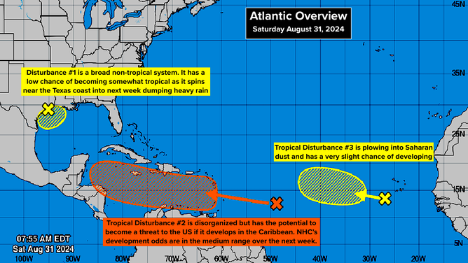
The National Hurricane Center is making note of 3 disturbances from near Texas to near Africa. The one of most interest is Tropical Disturbance #2 east of the Caribbean islands. Late next week, this system could be over extremely warm water and under conducive atmospheric conditions for strengthening in the western Caribbean Sea. But it has to get organized first, so no confident forecasts are possible.
The NHC is keeping the odds of development over the next 7 days in the medium range until the system shows clear signs of organization. The question is, can some part of the elongated area of disturbed weather in the tropical Atlantic break free into an independent system. The various computer forecast models are fairly bullish on that eventually happening, but predictions for undeveloped systems are always subject to significant changes.
Map of the Atlantic.
(NHC / FOX Weather)
Blocking high pressure to the north would seem to favor a track west through the Caribbean for most of next week. Many long-range forecasts show the system bending to the north into the Gulf around next weekend, but that's so far out that we can't pay attention to any specific forecasts.
Don't focus on any computer projections you see on the internet. Where the potential storm turns north (if it does) will depend on how quickly the system can organize and intensify (if it does) and the position and orientation of a jet stream dip moving into the Midwest that could pull it north. Subtle differences in these variables and others are responsible for the various development and track possibilities you might see online.
At this point, just be aware of a potential storm threat near Mexico's Yucatán Peninsula about next weekend, and in the Southeast the following week.
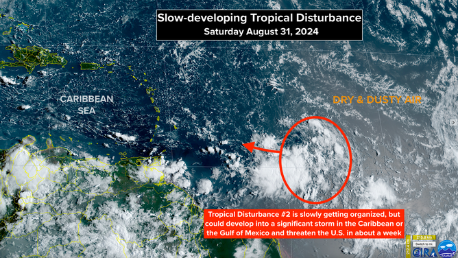
Slow-developing tropical disturbance.
(NHC / FOX Weather)
IN THE GULF: The system offshore of the Texas and Louisiana coasts, Disturbance #1, is a non-tropical system but has a slight chance of taking on some tropical characteristics if it stays offshore. Whether it technically becomes tropical or not, the rain is going to add up, especially near the coast. Both the Houston and New Orleans metropolitan areas are in the rain zone. The heaviest rain should fall south of I-10.
A combination of the existing low-pressure system, an upper-level disturbance, and an approaching tropical disturbance will keep periods of rain going through much of the coming week. Stay up to date on local information and instructions in coastal Louisiana and Southeast Texas.
NEAR AFRICA: Tropical Disturbance #3 is slowly moving west through a plume of dry and dusty air. The National Hurricane Center has its development chances in the low range over the next week. At this point, it does not look like a threat to land, but we always have to watch slow-moving systems.