Bryan Norcross: Extreme flood threat from North Florida to North Carolina as Debby crawls across Southeast
The flash flood threat in southeast Georgia and the southern half of South Carolina is at the highest level that the National Weather Service issues. Based on everything we know now, this will be a water disaster for a large swath of the southeastern U.S.

Bryan Norcross: Debby slows down after landfall bringing extreme flood threat
FOX Weather Hurricane Specialist Bryan Norcross explains why Tropical Storm Debby's slow movement could cause catastrophic flooding across the Southeast this week where more than 24 inches of rain are forecast.
UPDATED Monday, Aug. 5 at 11:55 a.m. ET
Debby is now a tropical storm over North Florida. It missed Tallahassee, the largest population center in the area, but will bring relentless rain to areas east of there as it tiptoes into Georgia and eventually the Carolinas. The process is going to take most or all of the week. Relentless rain with gusty wind will slowly spread to the east.
The National Weather Service's current forecast for rainfall shows a bullseye across much of the Georgia and South Carolina Low Country with 18 to 24 inches. Some areas are forecast to get 30 inches of rain. The flash flood threat in southeast Georgia and the southern half of South Carolina is at the highest level that the National Weather Service issues. Here's the current forecast map for rainfall, which is subject to change, depending on where Debby stalls, loops, and its bands set up.
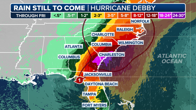
Rainfall forecast through this week.
Based on everything we know now, this will be a water disaster for a large swath of the southeastern U.S.
If Debby's center moves offshore, it's likely to strengthen and, therefore, produce even more rain and storm surge at the coast. High tides up to 4 feet above normal are possible somewhere on the Georgia and South Carolina coasts midweek. The storm surge will also have the effect of stopping the rainwater that's flowing down the rivers and trying to get into the Atlantic from making it all the way. This is another mechanism for flooding in the areas near the coast.
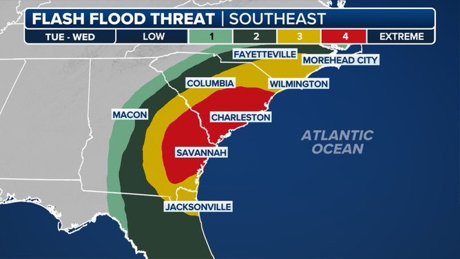
Southeast flash flood outlook through Wednesday.
Everybody from North Florida to eastern North Carolina should listen for information and instructions from local officials. Driving could become dangerous. If it were me, I would have enough food so I could stay home as long as the rain and gusty winds were affecting my area. Trees will come down, roads will be flooded, and in some cases, the water will be moving with enough force to undermine roads or bridges.
Additionally, Debby has two strong moisture tails. One relentless corridor of moisture has been over central and western Florida. Record rainfall has fallen at Sarasota, and gusty winds and heavy rain have caused problems from the West Coast through the Orlando area. This band of rain will only slowly move out.
The other moisture tail, with strong cells embedded in it, is over the Atlantic, rotating into Georgia and eventually South Carolina. It also has very gusty winds in the tropical downpours. It's just the opening round of the period of relentless rain and wind to come.
The consensus is that Debby will finally exit the Southeast on Saturday. The moisture will spread north throughout the week. Flooding rain in New Jersey and eastern Pennsylvania caused by Debby's moisture interacting with a cold front is forecast for Tuesday and Wednesday. Over next weekend or early next week, Debby's moisture might affect more of the Northeast.
Forecasts for slow-moving systems are always subject to change because the forces that steer the storms are subtle. Everybody in the affected areas needs to stay informed and stay aware.
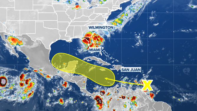
The outlook for a tropical disturbance in the Atlantic.
(FOX Weather)
Elsewhere in the tropics, a disorganized tropical disturbance is just about to cross into the Caribbean. Some computer forecast models show it developing a circulation later this week. The National Hurricane Center has its chances in the low range at this point.
Currently, it looks like high pressure would keep it well to the south of the US, although we always wait until the system develops to be sure.