Bryan Norcross: Debby's last day over Carolinas and another area to watch in Atlantic
Widespread rainfall of 12 to 15 inches has already fallen across the Carolinas, and 3 to 6 more inches are forecast in North Carolina today. Some areas are expected to receive a total of 2 feet.

FOX Weather is your Hurricane HQ.
(FOX Weather)
Updated at 9:30 a.m. ET on Thursday, Aug. 8, 2024
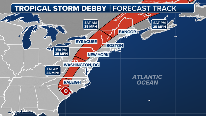
Tropical Storm Debby continues to crawl over the Carolinas. But this is the last day of the big stall. The system will begin its move to the north tonight and shoot quickly into the mid-Atlantic and Northeast tomorrow, taking its flooding rains with it.
Widespread rainfall of 12 to 15 inches has already fallen across the Carolinas, and 3 to 6 more inches are forecast in North Carolina today. Some areas are expected to receive a total of 2 feet. Unfortunately, the dangerous flooding will not end when Debby moves out because the water that fell in the Midlands of South Carolina and the Piedmont of North Carolina still has to drain to the ocean. Rivers, creeks and streams may overflow their banks, impacting surrounding roads, bridges and neighborhoods.
Forecast cone for Tropical Storm Debby.
(FOX Weather)
It's critical that everyone in the Carolinas stays in close touch with local officials for information and instructions about flooded areas.
In addition, tornadoes continue to be a threat in North Carolina in Debby’s intense outer bands. Most of the tornadoes are not very strong, but some have done significant damage. If you are under a rain band, be aware that a fast-moving tornado is possible at any time.
The flood threat will move north later today, affecting the mountainous areas, including the western parts of Virginia and West Virginia and all the way to the Northeast. The heaviest rain will fall inland away from the coast, but the I-95 corridor will be impacted tomorrow as well.
A cold front sweeping from the west will push the remnants of Debby offshore and give everybody a chance to dry out on Saturday.
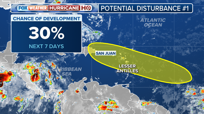
This graphic shows the area to watch in the Atlantic Ocean.
(FOX Weather)
Elsewhere in the tropics, the consensus of the computer forecast models is that a smudge of disturbed weather in the eastern Atlantic could develop into at least a tropical depression somewhere near the northeastern Caribbean islands around the middle of next week. There is no system to follow at this point, so forecasts are subject to change, of course.
More well-defined disturbances are developing over Africa, so we will likely have more systems to watch after the middle of the month.