Bryan Norcross: Extreme and extraordinary Hurricane Beryl assaulting southeastern Caribbean islands
Beryl is the first Category 4 storm to develop in June that we know of. Previous strong June hurricanes have only occurred in the Gulf of Mexico, never in the tropical Atlantic.

FOX Weather is your Hurricane HQ.
(FOX Weather)
Updated at 9:30 a.m. ET on Monday, July 1, 2024
Hurricane Beryl's assault on the islands in the southeast Caribbean, known as the Windward Islands, is underway. An event like this has never happened in June in recorded history.
Top winds dropped a notch last night to Category 3 as Beryl went through an internal restructuring – an eyewall replacement cycle – which is typical in intense hurricanes. The net effect is a slight decrease in the top wind speed, but strong winds spread over a larger area as the eye size expands. The eye then contracted again, and Beryl restrengthened and continues its track across the islands into the Caribbean as a Category 4.
Beryl is the first Category 4 storm to develop in June that we know of. Previous strong June hurricanes have only occurred in the Gulf of Mexico, never in the tropical Atlantic.
In 1933, a damaging and deadly hurricane hit Trinidad in June, but it was a Category 1. That's the only storm remotely like Beryl in the official records going back to 1851. People have been in Barbados for nearly 400 years, and we know that destructive hurricanes have hit those southeastern Caribbean islands through the centuries. But they were all in August, September or October.

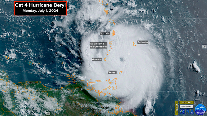
This is a satellite image of Hurricane Beryl on Monday, July 1, 2024.
(NOAA)
The center of Beryl and its band of fierce winds on the north side of the eye will blast through the islands this morning. It looks like Grenada and the islands just to the north called St. Vincent and the Grenadines will take the hardest hit. Although Tobago to the south will be near the core of the storm.
Beryl is still a relatively small-diameter hurricane, which allowed it to spin up so quickly over unusually warm water and under a supportive atmospheric pattern. But this also means that the most destructive winds don't extend very far from the center. The estimate is that 75-plus-mph hurricane-force winds extend 30-40 miles to the north of the center, and 40-plus-mph tropical-storm-force winds cover a diameter of just over 200 miles.
The storm's fast westerly motion adds to the winds on the north side of the circulation. That contribution is counted in the wind estimate. But the forward speed subtracts from the strength of the wind to the south. In Beryl's case, the 130-mph top-wind estimate includes the forward speed of 20 mph. That means the storm itself is generating about 110-mph winds. Then, on the south side, assuming everything is symmetrical, the forward speed counteracts some of the system's rotational winds, so an island there would feel a maximum wind of around 90 mph. Still a formidable hurricane.
The storm is being propelled by a strong high-pressure system sprawled across the Atlantic. The storminess along the East Coast of the U.S. yesterday was caused by a dip in the jet stream, which is weakening the high over the western Atlantic. This is why there is a northward bend in Beryl's track through the Caribbean. High pressure is forecast to build across the Southeast U.S. during the week, however, which should stop the northward movement so Beryl resumes moving westward with perhaps a bend to the south.
If this forecast is correct, part of the south coast of the Dominican Republic and Haiti might be threatened. Everybody in Jamaica, the Cayman Islands, Belize and Mexico's Yucatán should stay well-informed.
Extra-strong winds that typically blow across the eastern and central Caribbean combined with an upper-level headwind should weaken the hurricane once it gets past the islands. That weakening is reflected in the National Hurricane Center forecast, though it is still expected to be a dangerous storm when it passes or impacts Jamaica in a couple of days.
There is high confidence that Beryl will track west through the Caribbean, so there's no threat to Florida and the surrounding areas. The steering flow will slow down, however, about the time the storm gets near or over the Yucatán Peninsula. Slow-moving storms are always less predictable, so we'll keep open the possibility of Beryl ending up in the western Gulf next weekend. The odds of a problem for Texas don't appear high, but they're not zero at this point.
Following Beryl

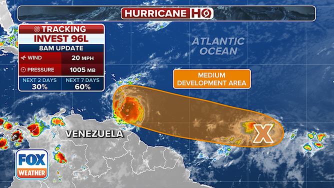
The latest on Invest 96L in the Atlantic Ocean on Monday, July 1, 2024.
(FOX Weather)
The system two days behind Beryl that the National Hurricane Center has tagged Invest 96L is still disorganized. It's wrapped up with a long area of disturbed weather called the Monsoon Trough just below the Saharan dust plume. "Monsoon" means seasonal, and "trough" means an elongated area of low pressure. This is a yearly feature in that part of the ocean.
The system is moving on a similar track to Beryl, but two days behind the hurricane. Between the nearby dust and the upper winds, the atmospheric pattern is forecast to be less conducive to strengthening than it was for Beryl.
The National Hurricane Center is now giving 96L a medium chance of developing into at least a tropical depression over the next day or two. That's down from yesterday. The various computer forecast models are now forecasting a somewhat more hostile pattern ahead.
On the current schedule, the system, whatever form it's in, would pass over the eastern Caribbean islands about Wednesday. It still has a chance to be a named storm at that time. Everybody in the Windward Islands needs to stay well-informed.
A flash in the Gulf pan

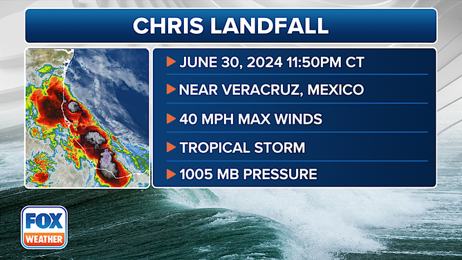
Information on the landfall of Tropical Storm Chris in Mexico on Sunday, June 30, 2024.
(FOX Weather)
Tropical Storm Chris formed in the Gulf just before the system we've been following there moved into Mexico. Top winds were only 40 mph, so the continuing rain is the major threat. It was the ultimate "shorty," organizing right before landfall.
Debby is the next name on the list. We'll see if the Atlantic system uses that name. There's nothing obvious up after that. Hopefully.