Bryan Norcross: The tropics are quiet, but don't forget 1969
No new systems are expected to develop in the tropics this month, and the pause might continue into August. But a couple of reminders are in order.

FOX Weather is your Hurricane HQ.
(FOX Weather)
Updated at 9 a.m. ET on Monday, July 22, 2024
The July lull in tropical development continues. The tropical Atlantic, the Caribbean and the Gulf of Mexico are covered with Saharan dust and dry air. High pressure is controlling the tropical-development belt.
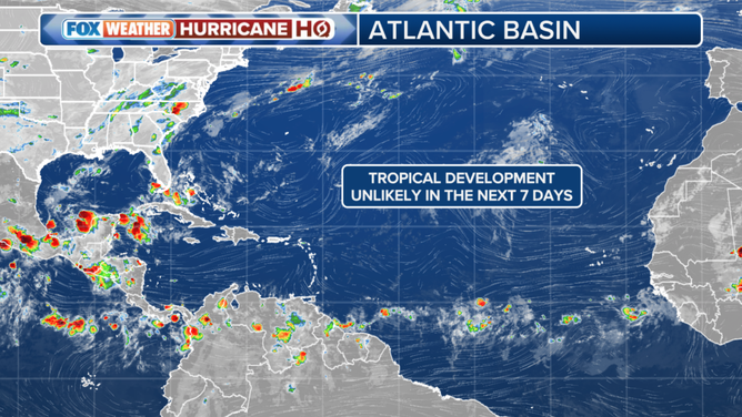
Tropical development is not expected in the Atlantic Basin over the next seven days.
(FOX Weather)
No new systems are expected to develop in the tropics this month, and the pause might continue into August. But a couple of reminders are in order.
On average, tropical development doesn't accelerate until about the second week of August. There is no record of a Category 3 or higher hurricane in South Florida, for example, before Hurricane Andrew's landfall date, which was Aug. 24. The graph from the National Hurricane Center tells the story.
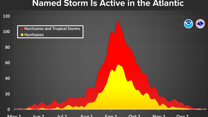
This graph shows that tropical storm and hurricane activity in the Atlantic Basin typically peaks from the second half of August into September.
(NOAA)
The peak date, when there is most likely to be a named storm somewhere in the Atlantic, is about Sept. 10. But notice the likelihood of storm development ramps up very quickly in the few weeks before that date and slowly tails off through the rest of September and October.
Dr. Bill Gray, the famous creator of seasonal hurricane forecasts, would ring a bell on Aug. 20 to officially kick off the busy part of hurricane season. He was right. Almost all consequential hurricanes occur after that date.
And don't forget 1969. June and July brought a couple of depressions and a tropical storm that year. Early August saw a short-lived tropical depression form in the Gulf, and an inconsequential hurricane track to the north well offshore of the U.S. East Coast. But when the middle of the month rolled around, BLAM! The tropics were off and running.
Early in the morning on Aug. 14, Tropical Storm Camille formed over the warm waters of the Caribbean south of Cuba. Camille turned north on a track toward the Florida Panhandle but veered left, building into an epic Category 5 monster before it slammed the Mississippi coast. Devastation was total. It took years to recover.
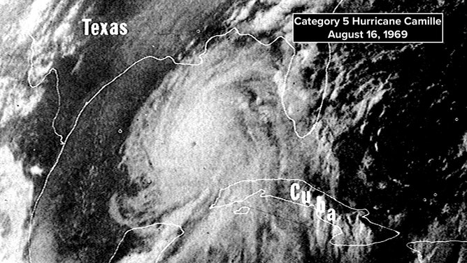
Satellite image of Hurricane Camille on Aug. 16, 1969.
(NOAA)
And hurricane season continued nonstop through October. Then a final hurricane spun up in the Caribbean in late November. In the end, 12 storms reached hurricane strength, which was the most since 1933. That record wouldn't be broken until the catastrophic 2005 season.
So why is this interesting? It turns out that the atmosphere/ocean pattern in 1969 is similar to what we are seeing this year. The Atlantic was warm, and the Pacific was in a weak El Niño state. This year, the Atlantic is extraordinarily warm, and the Pacific is in a neutral condition, which is only fractions of a degree from a weak El Niño.
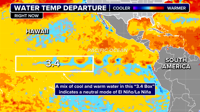
The Pacific Ocean is currently in a neutral condition, which is only fractions of a degree from a weak El Niño.
(FOX Weather)
Years in the neutral range can be very busy and also can be quite slow. Factors other than the El Niño/La Niña mode in the Pacific control how many storms form.
The bottom line is, the season has barely begun. Despite the freak development of Hurricane Beryl in June, the real starting line is around Aug. 15. Don't relax, but enjoy the break.