Bryan Norcross: The rest of July looks calm, then we begin to pay attention
Together, a high-pressure system, Saharan dust and the Madden-Julian Oscillation have prevented tropical disturbances moving off Africa from developing. This pattern is expected to last through at least the end of the month.

FOX Weather is your Hurricane HQ.
(FOX Weather)
Updated at 9 a.m. ET on Thursday, July 25, 2024
A strong and broad high-pressure system is sprawled across the Atlantic and as far west as the Gulf of Mexico. The circulation around the western nose of the high is pulling tropical moisture across the western Gulf and into the Southeast. The old cold front that brought comfortable weather to much of the northern U.S. is stuck in place across the South because of the strength of the high. That's why it's been so rainy in a belt from Texas to Virginia.
On the south side of the high, the wind flow from Africa is dragging Saharan dust across the tropical Atlantic, the Caribbean and into the Gulf. Add to the mix, the broad pulse that migrates around the Earth and enhances or suppresses thunderstorm activity, called the Madden-Julian Oscillation (MJO), has been in suppression mode over the Atlantic.
Together, the high pressure, the dust and the MJO have prevented tropical disturbances moving off Africa from developing. This pattern is expected to last through at least the end of the month.
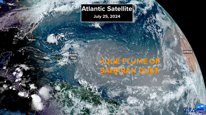
A huge plume of Saharan dust covers the tropical Atlantic on Thursday, July 25, 2024.
(NOAA)
Around the 1st of August, things get a little murky. The long-range European computer forecast model has been indicating that a disturbance currently in the far eastern Atlantic might develop when it gets near the northern Caribbean islands in about a week. We pay a little extra attention to the European model because, on average, it has made the best forecasts of where a storm will track over the past several years. It is generally NOT especially good at predicting when and where tropical systems will initially develop, however.
None of the other computer forecast models are showing the development, and it's normally the consensus of the best models that ends up being most accurate forecast.
WHY ATLANTIC HURRICANE SEASON COULD TURN ACTIVE AGAIN IN EARLY AUGUST
As of now, the consensus is that the disturbance will move through the northern Caribbean as a gusty moisture surge. The European is already backing off the idea that the system will develop, but we’ll keep an eye on it.
The disturbance will have to plow through a lot of Saharan dust on its way to the vicinity of the Caribbean islands. Often, tropical systems don't survive that trek.
Long-range projections show that the MJO will be in a mode that supports development over the tropical Atlantic by the middle of August. The support is predicted to be pretty weak, but it was also weak when Hurricane Beryl formed and tore through the Caribbean.
For now, enjoy the calm. Nothing here is unusual. If tropical activity doesn't pick up in August, that will be the surprise.