Bryan Norcross: Computer forecast models indicate a potential tropical threat next week
If the system is involved with the mountains of Puerto Rico or the Dominican Republic, it won't be able to organize much. But if organized low pressure forms over the Caribbean or the very warm Atlantic waters north of the islands, a storm could spin up.

FOX Weather is your Hurricane HQ.
(FOX Weather)
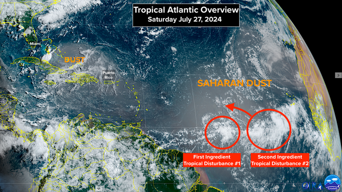
Midway between the Caribbean islands and Africa, there's an unremarkable smear of moisture that's the first ingredient in a potential system. I'm calling it Tropical Disturbance #1. Behind it, there's the second ingredient, a pretty robust system that moved off Africa a few days ago. I'm calling that one Tropical Disturbance #2. Both are blanketed by a huge plume of Saharan dust.
The dust is going to keep development to a minimum over the next few days. But after that, things get complicated.
Disturbance #1 is moving more slowly than Disturbance #2. If the computer forecasts are correct, the two systems will combine while Disturbance #2 lifts north, in a sense rotating above #1. Their mutual minimal moisture becomes enough to create something of a moist pocket over or near the northeast Caribbean islands about Wednesday or Thursday. That moisture could be sufficient for a system to develop.
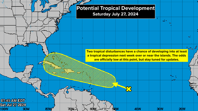
Potential Tropical Development
(NHC / NOAA)
At that point, there are many possibilities. If the system is involved with the mountains of Puerto Rico or the Dominican Republic, it won't be able to organize much. But if organized low pressure forms over the Caribbean or the very warm Atlantic waters north of the islands, a storm could spin up. The upper-level atmospheric pattern looks at least moderately conducive for a circulation to organize, assuming it's fought off the dry air.
The National Hurricane Center is giving the combined system a low chance of developing into at least a tropical depression next week. Systems that haven't even begun to consolidate are always given low odds when so many things have to fall into place for a circulation to develop. Remember, the NHC's yellow potential development zone is not a cone in the classic sense. The forecasters are saying that if a tropical depression or storm forms over the next 7 days, it will likely be somewhere in that area.
Tropical Atlantic Overview
(NHC / NOAA)
If a seed doesn't get properly planted, a strong tree doesn't grow. And in this case, the seed hasn't even come together yet.
If a system does form midweek, there are an array of possibilities from a blob of moisture to a potential threat. Possible paths range from east of Florida to a track into the Gulf of Mexico to dying over the mountainous islands.
Obviously, there are a number of steps to watch for with this system.
Nothing is going to happen immediately, and maybe it won't come together at all. Stay tuned.