Bryan Norcross: Some computer forecasts continue to show a possible tropical threat late this week
The computer forecasts that show a threat say the system could develop in the vicinity of the Bahamas late in the week. It would likely turn north, but where that would happen is an open question this far out.

FOX Weather is your Hurricane HQ.
(FOX Weather)
Updated at 10 a.m. ET on Sunday, July 28, 2024
Primarily based on the European computer forecast model, the National Hurricane Center is painting a large potential development area from the Atlantic waters well east of Puerto Rico and the Virgin Islands to Florida. They are calculating that there is a medium chance of at least a tropical depression developing in that area over the next seven days. At this point, just take it as an alert that everyone should be prepared for the hurricane season to come.
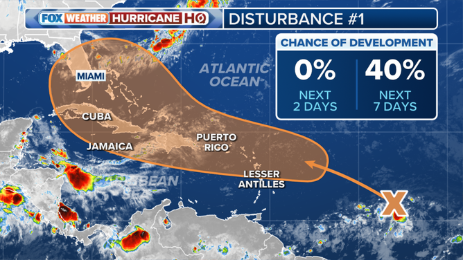
The outlook for a tropical disturbance in the Atlantic.
(FOX Weather)
The various computer models have an unusually diversified set of predictions about the nature of the atmospheric pattern over the southwestern Atlantic, including over the Bahamas and Florida, late in the week. The European model shows a bubble of atmosphere conducive to tropical development, while other computer forecasts predict a less hospitable pattern.
The system in question hasn't even begun to form. Potential development is coming from two disturbances over the open tropical Atlantic. Tropical Disturbance No. 1 is a cluster of thunderstorms at a low latitude about two-thirds of the way from Africa to the Caribbean. Tropical Disturbance No. 2 is a large system that moved off Africa last week. It's generating very few thunderstorms because it's embedded in a giant plume of Saharan dust.
There is consensus among the various computer forecasts that these systems will combine and result in a gusty, moisture surge moving across the northeastern Caribbean islands, including Puerto Rico, beginning about Wednesday. After that, things get much more uncertain.
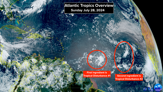
Satellite image of the Atlantic Basin on Sunday, July 28, 2024.
(NOAA)
The computer forecasts that show a threat say the system could develop in the vicinity of the Bahamas late in the week. It would likely turn north, but where that would happen is an open question this far out.
It's important to remember that forecasts for undeveloped or just-developing systems are always subject to large changes. This is an extreme case of an undeveloped system because it relies on two separate systems combining into one disturbance and then organizing without being disrupted by the mountainous islands in the northern Caribbean.
There's another reason to wonder about the forecasts that show significant development. The Eastern Pacific is getting quite busy. The National Hurricane Center is watching three areas there. Often, when the Eastern Pacific is generating storms, the Atlantic is relatively quiet. That's not 100%, however.
For now, the only thing to do is stay informed and check your hurricane supplies to be sure you're ready for the season, whether this system becomes a threat or not.