Bryan Norcross: Watching for possible tropical development that could impact Florida or the Southeast
A number of computer forecasts turn the system north just east of Florida, others take it into the Gulf, and others don't develop it at all. In addition, based on what we know from these forecasts, there's a non-zero chance of a storm affecting the East Coast of the U.S.

Bryan Norcross: These factors could hinder development in the Atlantic
FOX Weather Hurricane Specialist Bryan Norcross explains the odds of development in the Atlantic and what could hinder its chances of formation.
Updated at 9:30 a.m. ET on Monday, July 29, 2024
The National Hurricane Center has the odds at 50% that at least a tropical depression will develop somewhere in a large zone from near Puerto Rico across the Bahamas and curving north, including both sides of the Florida Peninsula. As is usually the case with a system that has not yet formed, computer forecasts are less reliable and change with every cycle.
The details of any specific computer projection are not important. That's why the NHC draws a broad potential development area encompassing the reasonable possibilities. Based on the forecast upper-level pattern, the system is more likely to develop when it's closer to the Bahamas or perhaps near Florida than it is near Puerto Rico or the nearby islands.
The key component of the ingredients that could come together into an organized system is a large, spinning tropical disturbance – ingredient No. 2 – embedded in a giant cloud of Saharan dust. As it gets closer to the islands, the forecasts show it drawing in moisture from another disturbance to the south – ingredient No. 1. Then a system can try to consolidate. It normally takes time for large, dry systems to pull themselves together, but in this case, it will be moving across record-warm ocean water, which means it has extra energy to work with.
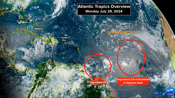
The two ingredients for a tropical system have a medium chance of coming together to develop into a tropical depression or tropical storm in a few days.
(NOAA)
So the odds don't appear high that the disturbance would suddenly develop and strengthen, but tropical systems that form over the extremely warm waters in or near the Bahamas always bear watching closely. On the off chance that the storm suddenly spins up into something significant, the warning window in Florida or the Southeast would be shorter than normal.
A consensus of the computer forecast models predicts that the two ingredients in the tropical Atlantic will first combine into a gusty moisture surge that will affect Puerto Rico and the surrounding islands in a couple of days. On the current schedule, the system will reach the vicinity of the Bahamas by Friday. Then things get murky. The future depends on how organized the system is at that time.
A number of computer forecasts turn the system north just east of Florida, others take it into the Gulf, and others don't develop it at all. In addition, based on what we know from these forecasts, there's a non-zero chance of a storm affecting the East Coast of the U.S.
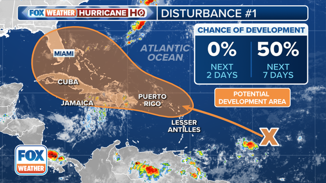
The outlook for a tropical disturbance in the Atlantic.
(FOX Weather)
If the system develops, impacts in Florida would begin about Saturday and points north early next week. Whether it's a gusty moisture surge, a depression or a more significant storm that affects somewhere in the Southeast or along the East Coast is an open question.
There's nothing to do right now but stay informed. Hopefully, this is much ado about nothing. But when credible computer forecast models insist something might develop close to land, and the ocean temperature is at record levels, we have to pay extra attention.