Bryan Norcross: Hurricane Beryl to impact Jamaica today as strength, track in Gulf remain uncertain
Jamaica has a complex coastline and terrain with mountains over 7,000 feet high. A slight jog in the track changes which parts of the island receive the strongest winds, the highest storm surge, and the heaviest rain.

FOX Weather is your Hurricane HQ.
(FOX Weather)
Updated at 9:30 a.m. on Wednesday, July 3, 2024
Hurricane Beryl is bearing down on Jamaica. It will take a good part of the day for the storm to get past the entire island. Unless it unexpectedly makes a sudden jog to the north, it looks like Beryl's center will pass just south of the island. The strongest winds are in the northern semicircle. Unfortunately, they're in line to impact the island.
Jamaica has a complex coastline and terrain with mountains over 7,000 feet high. A slight jog in the track changes which parts of the island receive the strongest winds, the highest storm surge, and the heaviest rain.
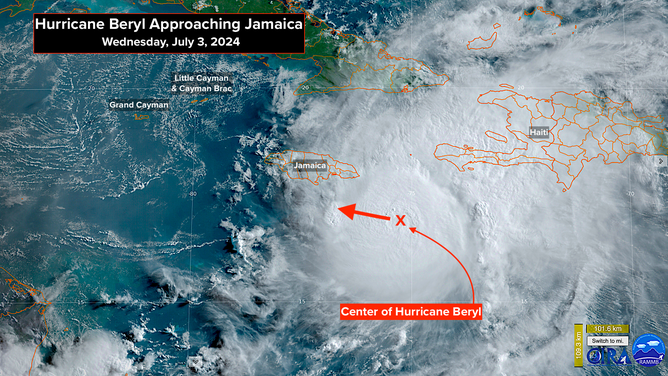
A satellite image of Hurricane Beryl.
Fortunately, Beryl is moving along at a good clip, which will limit the height of the storm surge and the amount of rain that falls on the island. But still, tides up to 9 feet above normal and locally, a foot of rain is forecast by the National Hurricane Center. Jamaica has a history of dangerous mudslides from heavy rain. Hopefully, full hurricane preparations have been completed across the island.
The Cayman Islands are next in line. Even though Beryl should be somewhat weaker by the time it gets near the Caymans, it will still be a very dangerous hurricane. Grand Cayman is most likely to feel the worst effects because it will be closer to the center of circulation. Tides up to 4 feet above normal are possible on all the islands, however. Full hurricane preparations are required.
What happens next?
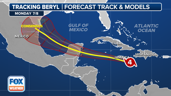
This graphic shows the forecast track of Hurricane Beryl.
(FOX Weather)
What happens next is more uncertain than normal. Beryl will be encountering upper-level headwinds and dry air, so the atmospheric pattern will be at least moderately hostile. The degree of hostility is an open question, however. So far, Beryl's core has been able to fight off the intrusion of dry air being pushed toward the storm. The unusually warm water temperatures in the Caribbean might be supplying enough energy to the core to power thunderstorm development and hold off some of the dry air.
Even though it appears Beryl's center will pass south of Jamaica, the circulation might be disrupted to some degree by the mountains. A disorganized system has a harder time fighting off dry air intrusion and can further weaken. If the hurricane skates by Jamaica intact, however, it will be stronger as it passes the Cayman Islands and approaches Mexico's Yucatán Peninsula.
The National Hurricane Center is forecasting Beryl to be a Category 2 when it reaches the Yucatán, which means people there should be ready for a Category 3 just in case Beryl's core remains intact. The upper-level winds are forecast to be more conducive to strengthening when the storm is approaching the Yucatán.
By the time Beryl reaches the Gulf late Friday, the steering pattern is forecast to change. The storm will slow down, and there will be a dip in the jet stream to the north. Beryl's strength at the time it gets to the Gulf will have a bearing on whether the jet stream dip pulls it north to Texas, or if it arcs generally westward toward Mexico.
The various computer forecast models are showing a wide variety of possibilities. We should have a better idea of what's going to happen after Beryl passes Jamaica. We'll see what shape the storm is in, and how the hostile atmospheric pattern is affecting it.
Everyone on the Texas coast should stay informed over the holiday weekend until the forecast becomes clearer.
The disturbance following Beryl
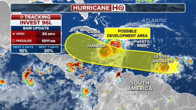
This graphic shows the latest with Invest 96L.
(FOX Weather)
The area of disturbed weather east of the Caribbean islands that we have been watching, officially called Invest 96L, is not organizing. It's been trapped in an envelope of Saharan dust, and the upper-level winds are only moderately supportive of development.
The National Hurricane Center is now giving this system a low chance of developing.
In any case, the system is forecast to move through the eastern Caribbean islands today as a moisture surge with gusty squalls. Some of the tropical downpours will impact the islands devastated by Beryl, but most of the squally weather will be north of Barbados. Puerto Rico will feel the effects tomorrow. Locally heavy rain is likely.
The disturbance will continue across the Caribbean as a weak system with a slight chance of developing.
After Beryl, long-range computer forecast models show the tropics calming down nicely. Nothing else is forecast for at least the next week.