Bryan Norcross: High uncertainty how tropical disturbance will develop, where it will impact
Due to the dry air, there are few, if any, thunderstorms associated with the system, but the consensus of the various computer forecast models is that moisture will be pulled into the disturbance, and thunderstorms will develop as it tracks over Puerto Rico and the nearby islands in the next couple of days.

Bryan Norcross provides update on tropical disturbance in Atlantic
FOX Weather Hurricane Specialist Bryan Norcross analyzes the latest models regarding the tropical disturbance that is being tracked in the Atlantic Ocean this week.
Updated at 9 a.m. ET on Tuesday, July 30, 2024
A large tropical disturbance that moved off Africa last week is embedded in a massive cloud of Saharan dust. Due to the dry air, there are few, if any, thunderstorms associated with the system, but the consensus of the various computer forecast models is that moisture will be pulled into the disturbance, and thunderstorms will develop as it tracks over Puerto Rico and the nearby islands in the next couple of days.
The two "ingredients" we’ve been following the last couple of days have essentially now become one system.
The European computer forecast model has insisted that the system will track toward the Bahamas and eventually develop into at least a tropical depression. The other computer forecasts have oscillated, but generally delay consolidation and organization, tracking the system into the Gulf with possible development there.
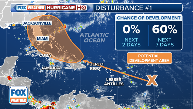
Based on the consistency of the European-model forecasts, and the consensus that the upper-level winds will be conducive for tropical development, the National Hurricane Center is now giving the system a 60% chance of developing into at least a tropical depression.
The outlook for a tropical disturbance in the Atlantic.
(FOX Weather)
The NHC's potential development zone is not a cone per se. It's the area where there's a decent chance a depression or a tropical storm will form later this week or over the weekend. Notice that it acknowledges the possibility of development over the Atlantic, the Florida Peninsula or in the Gulf.
The odds say that the system is more likely to turn north offshore of Florida if it gets stronger sooner. Conversely, it's more likely to track over Florida or into the Gulf if it stays fairly weak. There is no way to know if the system will have been able to shed the dry air and develop a circulation by the end of the week when the atmospheric pattern is forecast to become conducive for strengthening. For now, we can only talk about possibilities.
The disturbance looks likely to be over the northeastern Caribbean islands tomorrow and Thursday, then over or near the Bahamas Friday into Saturday. Effects in South Florida could begin on Saturday or Sunday. But the predictions will be fuzzy until an organized system actually forms, if it ever does.
It will likely come through the islands as a gusty moisture surge. Then, at some point, the consensus is that the system will organize and strengthen to some degree, but it's too early to know when, where and how much.
If significant development occurs in the Bahamas, the consensus of the computer forecasts is that the system will turn north to the east of Florida, though coastal impacts would be possible. A system that develops more slowly is more likely to track over the peninsula or into the Gulf, where it could strengthen before reaching the Gulf Coast next week.
Needless to say, uncertainty is high, as it always is when an organized tropical system has not yet developed.
For now, just plan to stay informed toward the end of the week. An annoying thing about this system is that it has the potential to develop over the Bahamas, which obviously is not far from Florida. That means there would only be a short time window to prepare on the off chance that something stronger than expected develops.
Stay aware. Be prepared. Just in case.