Bryan Norcross: Slow-developing disturbance likely to impact Florida starting this weekend
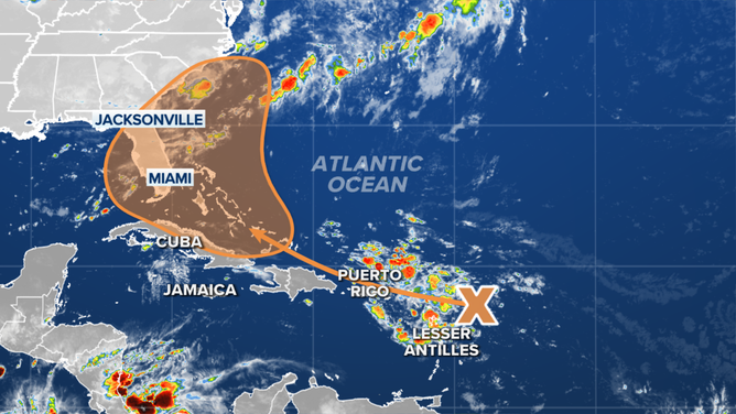
The National Hurricane Center is currently putting the odds of at least a tropical depression developing in the orange area over the next 7 days at 60%. If the system attains winds of at least 40 mph, it will be named Tropical Storm Debby.

Bryan Norcross provides update on tropical disturbance in Atlantic
FOX Weather Hurricane Specialist Bryan Norcross says models are starting to agree on the future of a tropical disturbance in the Atlantic Ocean, but there is still a lot of uncertainty.
Updated at 9 a.m. ET on Wednesday, July 31, 2024
The large, lumbering disturbance we've been following the last few days is pushing gusty tropical downpours across the northeastern Caribbean islands and surrounding waters. The squally weather will continue into Thursday as the disturbance continues to moisten.
The system doesn't have any trackable center yet, so forecasts have larger-than-normal uncertainty. When and if a center does form, the location is critical to what happens later this week and early next week.
The consensus of the latest computer forecasts is that the disturbance will pass over the mountains in Puerto Rico and the Dominican Republic on Thursday. How it emerges from that encounter will set the stage for what comes next.
If a nascent circulation forms over the abnormally warm waters north of the islands, the system is likely to be stronger or at least primed for strengthening when it reaches the vicinity of the Bahamas about Friday. It will also be more likely to take a path near or offshore of the east coast of Florida.
If, however, the system consolidates in the waters between Haiti and Cuba, it will interact with the long Cuban mainland and has a better chance of ending up in the Gulf.
The various computer forecast models pretty much agree on the timing of the movement of the disturbance, but not on how strong it will be when it's in the general vicinity of Florida or the northwestern Bahamas over the weekend.
The outlook for a tropical disturbance in the Atlantic.
(FOX Weather)
It's increasingly likely that some effects from the system will move over the southern Florida Peninsula beginning on Saturday. It's not likely that the system would have time to dramatically strengthen, but disruptive impacts – heavy rain in gusty squalls – are possible over the weekend if a core of tropical moisture is dragged over the state. There is consensus in the computer forecasts that that will happen, but to varying degrees.
The rest of Florida, the Southeast coast and the northern Gulf Coast all have a chance of being affected next week depending on where the system forms Thursday or Friday. If the system attains winds of at least 40 mph, it will be named Tropical Storm Debby.
The computer forecasts indicate that the stronger the system becomes in the short run, the more likely it is to turn north and stay well offshore of Florida. Computer projections that track the disturbance over the mountainous islands or keep it weak for other reasons are more likely to show the system more slowly moving north over or near Florida or into the Gulf of Mexico.
The National Hurricane Center's potential development area skews toward the Atlantic because most of the possible tracks of a stronger, better-developed system arc that way. In other words, weaker possibilities that don't qualify to be at least a tropical depression and move into the Gulf are not included in their 7-day potential development zone.
The National Hurricane Center is currently putting the odds of at least a tropical depression developing in the orange area over the next 7 days at 60%.
And there's another wrinkle to consider. The system is forecast to turn north through a gap between the typical Bermuda high over the Atlantic and the heat dome high over the middle part of the U.S. As we saw with Hurricane Beryl at the beginning of the month, which turned north toward Houston through a similar gap in the highs, predicting exactly how that channel will configure itself days in the future is always iffy.
If the system attains a circulation and begins to strengthen near the Bahamas, it could be a threat to the Carolinas and maybe the mid-Atlantic early next week. If it doesn't organize, it will likely move more slowly over Florida or into the Gulf.
Until the system develops a center of circulation, if it does, the future track is unknowable. Zigs and zags and stalls are all possible, so don't lock in on any one idea. Just plan to stay informed.