Bryan Norcross: Hurricane Watches for Hurricane Beryl will likely be issued for Texas on Friday
Reasonable possibilities bring impacts as far north as Galveston at the coast, and as far inland as San Antonio and Austin. Be ready for storm surge at the coast and heavy tropical downpours with gusty winds inland.

FOX Weather is your Hurricane HQ.
(FOX Weather)
Posted Friday 10:15 a.m. ET
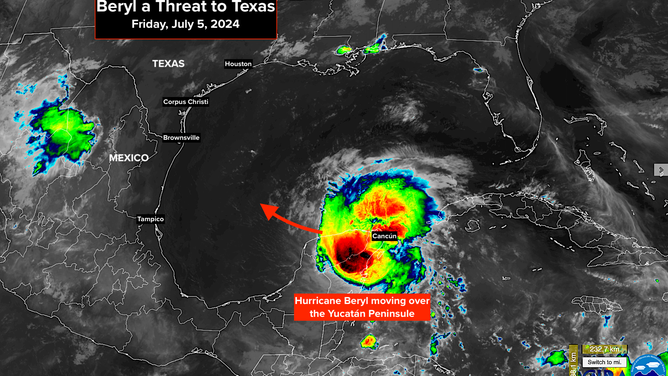
Hurricane Beryl made landfall just north of Tulum on Mexico's Yucatán Caribbean coast Friday morning. The strongest winds and heaviest rain bands impacted Cancun and Cozumel. Top winds were estimated at 110 mph at landfall.
Through the day today, Beryl is likely to weaken as it traverses the Yucatán landmass, emerging into the Gulf late Friday night. After its land interaction, there is some question about how well organized the circulation will be when it gets back over the Gulf on Saturday. The less organized it is, the longer it will take to restrengthen as it tracks over the warm Gulf waters toward Texas or northern Mexico.

Forecast cone for Hurricane Beryl
(FOX Weather)
What to expect next
Hurricane Watches will likely be issued for Texas today.
The steering currents will not be strong over the Gulf, meaning Beryl will slow its forward speed. The thinking is that this will give it time to restrengthen into a hurricane. The big question is, how quickly will that happen?
A dip in the jet stream over the Midwest will want to turn Beryl north to one degree or the other. As a general rule, stronger storms react to jet stream dips more than weak ones. The consensus of the computer forecast models is that a stronger Beryl will make a harder turn to the north than one that stays at tropical storm strength.
The National Hurricane Center is forecasting Beryl to reach solid Category 1 strength before it reaches the western Gulf. If it is that strong or stronger, the odds favor a turn toward the Texas coast.
Everybody from Brownsville to metro Houston should stay well informed over the weekend.
Preparation and impact
In most imaginable scenarios, including a landfall in northern Mexico, impacts will be felt in South Texas. The question is, how far north and how far inland will Beryl track? Reasonable possibilities bring impacts as far north as Galveston at the coast, and as far inland as San Antonio and Austin.
That's not a forecast at this point, but it's a reasonable possibility for early next week. Be ready for storm surge at the coast and heavy tropical downpours with gusty winds inland.
Potential impact on East Texas
The magnitude of the impact on east Texas will mostly depend on how much Beryl restrengthens in the Gulf. The upper-level wind regime appears conducive for strengthening, and the water is extra warm, though there is expected to be dry air the storm will have to fight off.
Also, as mentioned earlier, the rate of strengthening depends to some degree on how disrupted the circulation becomes over the Yucatán landmass.
Stay aware and stay well informed.
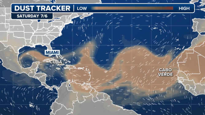
Elsewhere in the tropics
The National Hurricane Center has given up on the system that was called Invest 96L. It's now just expected to cross the Caribbean as a moisture surge and move across Central America and into Mexico by the middle of next week.
(FOX Weather)
After Beryl, the tropics are expected to return to a more typical July state. Dust will cover much of the tropical Atlantic. No development is expected through next week, at least.