Bryan Norcross: Beryl to impact Texas coast beginning Sunday with landfall Monday
The expectation is that Beryl will organize and intensify before reaching the Texas coast. High winds, storm surge, heavy tropical rain, and some tornadoes are forecast.
Beryl expected to be a hurricane as it hits Texas
There is an increasing risk of damaging hurricane-force winds and life-threatening storm surge along the Texas Coast late Sunday into Monday, where Hurricane and Storm Surge Watches are in effect. Additional watches and warnings may be required later Saturday.
Updated 9 a.m. ET Saturday
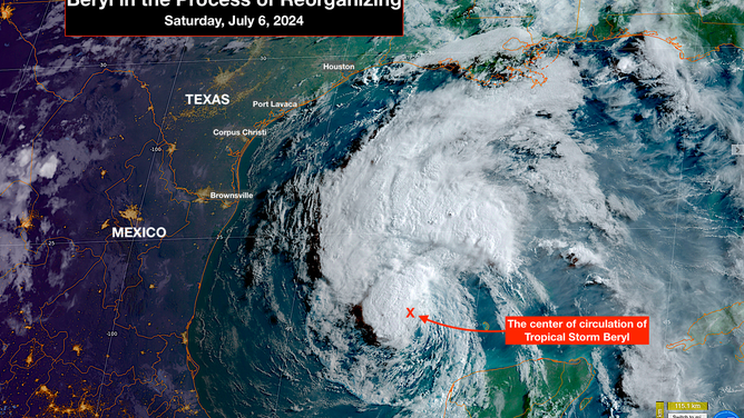
Tropical Storm Beryl is reorganizing in the Gulf. It was torn apart by hostile upper winds and its trek over the landmass of the Yucatán peninsula of Mexico. As you can see in the satellite, thunderstorms are beginning to wrap around the center, which is the first step in the process. The expectation is that Beryl will organize and intensify before reaching the Texas coast. High winds, storm surge, heavy tropical rain, and some tornadoes are forecast.

Tropical Storm Beryl is reorganizing in the Gulf.
(NOAA)
Alerts for hurricane-force winds and storm surge have been issued for most of the coastline. A storm surge of up to 5 feet above the normal high tide level is forecast in a wide area of the central Texas coast including Corpus Christi and Matagorda Bay, and up to 4 feet elsewhere including Galveston Bay. Flash flooding and tornadoes are also a threat across the eastern part of the state. It's critical that everyone in Texas, including in metro Houston, stays well informed this weekend.

Alerts for hurricane-force winds and storm surge have been issued for most of the coastline.
(NOAA)
Messaging to the public is going to be difficult for this storm because there's a decent chance the storm will look pretty weak moving across the Gulf and then strengthen quickly when it's near the coastline. It will likely remain a tropical storm today, and then pull itself together so that it intensifies into a hurricane tomorrow as it's on its way to landfall.

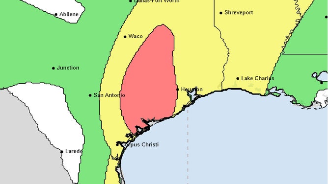
Flash flooding and tornadoes are also a threat across the eastern part of the state.
(NOAA)
The landfall point will likely be unusually difficult to pin down with this storm. If Beryl behaves as forecast, it will be turning north as it nears the coast. When a storm parallels the coastline, the slightest angle difference in its track dramatically changes where the center crosses onto land. The worst weather and the highest storm surge are generally just to the right of that landfall point. In a paralleling storm, a longer strip of the coastline has to be on alert because a wobble can change the maximum impact point by many miles.
There are at least 3 reasons the forecast landfall point changed so dramatically in the past couple days.
- First is the geometry of the coast and the track. As I said, landfall for paralleling storms is always subject to significant adjustments.
- The second important point is the fundamental rule that forecasts for disorganized, disorganizing, or just organizing storms always have larger errors. Beginning when Beryl was approaching the Yucatán, the system became disrupted by hostile upper winds and dry air. From that point on, potential for larger forecast track errors increased.
- And third, the turn to the north is being caused by a dip in the jet stream that is cutting an opening between two high-pressure systems. These two bubbles of hot air have been responsible for record-high temperatures on each coast. The 124 degrees at Palm Springs and 106 at Raleigh were a bit higher than forecast, so the highs must have been stronger. Stronger highs force the low-pressure jet-stream dip between them to be sharper and deeper, which has had the effect of pulling Beryl more to the north.
On the current schedule, the weather will deteriorate in coastal South Texas tomorrow afternoon then spread north to include metro Houston late at night or Monday morning. Landfall will likely occur on Monday. The center will cross the coast Monday morning if Beryl makes landfall in South Texas, and later in the day if it's farther up the coast, which appears more likely.
Beryl is forecast to be a Category 1 hurricane at landfall, but if it tracks farther to the north and stays over the Gulf, it could be stronger. A Category 2 or 3 is not out of the question. There is likely not time for it to get any stronger than that.
The Gulf coast is structurally very vulnerable to storm surge, so the National Hurricane Center has alerts out for the Gulf water to rise up to 5 feet above normal high tide for a good part of the Texas coast. If you're near the Gulf, bays, rivers, harbors, or inlets, be sure you're aware of the latest information for your area from your local emergency management office and the National Weather Service.
Beryl will not move quickly over east Texas, but it will keep moving, so this won't be a Hurricane Harvey situation where the storm endlessly stalls. A foot of rain or more in some areas is not out of the question. Over most of the eastern part of Texas including metro San Antonio, Austin, and Houston there is a risk of flash flooding.
This situation is going to develop quickly tomorrow, which will be the day for final preparations for millions of people. Stay aware and stay informed.
