Bryan Norcross: Impacts from Beryl begin Sunday with landfall on the Texas coast overnight
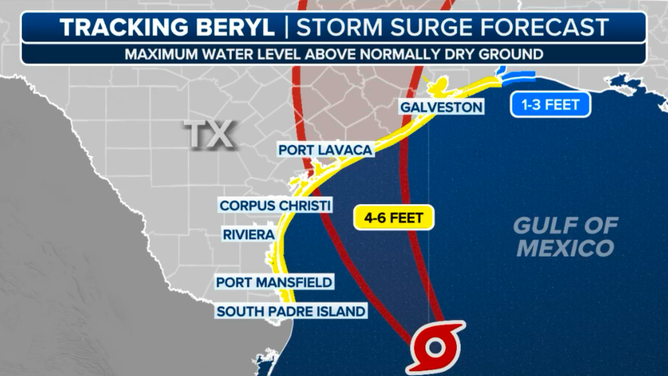
It's critical that everybody near the Gulf, inland bays, waterways, harbors, and bayous knows the potential water rise forecast for their area and pays attention to information and instructions from emergency management. Storm surges will be life-threatening in some areas.
Bryan Norcross: Beryl expected to strengthen before Texas landfall
FOX Weather Hurricane Specialist Bryan Norcross explains how Beryl could strengthen in the Gulf of Mexico before making landfall in Texas.
UPDATED Sunday at 10 a.m.
Beryl is still in the process of pulling itself together. The storm is more organized than it was yesterday and is more or less on the forecast track. A strong outer rain band will rotate across much of the Texas coast through the day today, so watch for torrential tropical downpours and frequent lightning increasing through the day.
Beryl's center of circulation will slide by offshore of South Texas today with a landfall expected in the overnight hours between Corpus Christi and the southern suburbs of metro Houston. Coastal communities in central and northern Texas are at high risk of being flooded from storm surge in the areas where the strongest winds are blowing onshore.

Beryl seen on satellite imagery.
Along the coast just to the right of where the center of Beryl makes landfall, the storm surge is forecast to be up to 6 feet above normal high tide. If you stand on the shoreline at the high tide line, it's easy to imagine what 6 feet of water above that point means. This doesn't mean it will be 6 feet everywhere in that area. It means that somewhere in the zone with the 6-foot forecast, the water could be that high if the peak surge comes at high tide. Gulf water will rise due to Beryl's winds as far north as southwestern Louisiana.
If the center makes landfall overnight as projected, the good news is that the tide will be low at that time, reducing the height of the water by a foot or 18 inches.

Beryl storm surge forecast.
In any case, it's critical that everybody near the Gulf, inland bays, waterways, harbors, and bayous knows the potential water rise forecast for their area and pays attention to information and instructions from emergency management. Storm surges will be life-threatening in some areas.
Hurricane warnings are issued for areas where winds have a good chance of reaching 75 mph or higher. Hurricane warnings only address the wind threat. Tropical storm warnings mean that winds have a good chance of being 40 mph or higher, which are strong enough to knock down trees and powerlines. So everybody in the warning zones should be ready for the power to go out and think about where their car is parked. Find a spot that isn't prone to flooding and where a tree isn't likely to fall on it.
It looks likely that Metro Houston will be on the right side of Beryl's circulation. That's the side with the heaviest rain and the possibility of tornadoes. The tornado threat peaks in advance of the arrival of the center of the storm. Tomorrow will be a disrupted and potentially dangerous day in most of East Texas including metro Houston. Plan accordingly.
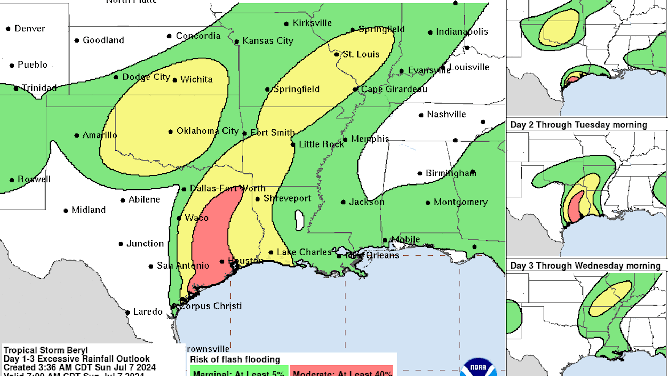
Beryl will bring up to 10 inches of rain, with some spots getting more, so flash flooding will be a threat in some areas. This will not be a Harvey situation, but currently the corridor of heaviest rains will fall in the western and northern counties of the Greater Houston Metro. That water will flow into the creeks, bayous, and rivers, which can result in downstream flash flooding.

Beryl flooding potential.
Beryl will keep moving into Arkansas, toward St. Louis, and into the Midwest. Stay aware of the potential for flooding well away from the Gulf as well.
Beryl's circulation is not large, which means it can spin up quickly. There is less air to get moving if the conditions are just right, and it has enough time to really intensify. It's still forecast to make landfall as a strong Category 1, so we plan for at least a Category 2.
Pay attention. Stay aware. Stay informed. Keep your phone charged. Park your car with care. Don't stay in dangerous areas near the Gulf, bays, or waterways, or in low-lying areas inland.
