Bryan Norcross: Beryl heads past Houston taking dangerous flash flooding and wind threat north
Texas was very lucky that Beryl could not completely shed the dry air that was wrapping around its circulation, as many of the computer forecast models predicted it would.

FOX Weather is your Hurricane HQ.
(FOX Weather)
UPDATED Monday at 12:20 p.m. ET
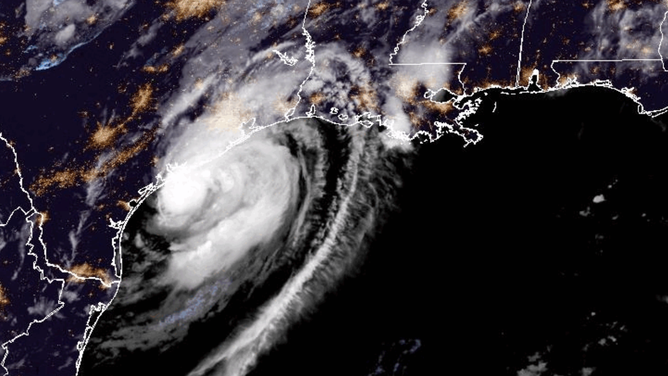
Beryl made landfall near Matagorda, Texas, about 80 miles southwest of Houston, early this morning. Top winds were estimated at 80 mph when the center of the broad eye-like feature crossed the coast. Storm surge at the official gauges ranged between 3 and 4 feet above the normal high tide level. We won't know the official numbers until a coastal inspection is complete.

Hurricane Beryl satellite imagery from 7/8/2024
(NOAA)
Texas was very lucky that Beryl could not completely shed the dry air that was wrapping around its circulation, as many of the computer forecast models predicted it would. It could never close off a tight eye, which it would have had to do to intensify rapidly. It couldn’t complete the doughnut of strong thunderstorms — the eyewall we see in strong hurricanes — due to dry air on the west side. That held the intensity to Category 1.
We’ve seen a number of examples in the past when storms that get disrupted by land end up with a wide-diameter eye-like structure and can't bring in its "arms." (Like a figure skater brings their arms closer to their body to spin faster.) The lack of a solid inner core apparently made Beryl a much less impactful storm than it could have been. But we’ll wait for the final surveys.

Gulf Coast Rain Forecast
(FOX Weather)
Even today, as the still-formidable Tropical Storm Beryl moves past Houston, you can see the erosion on its backside. It's only about two-thirds of the storm. The heavy rain and wind are in front of and to the right of the center of circulation.
Beryl will exit metro Houston this afternoon and spread heavy rain with the potential of flash flooding north and northeast over the next couple of days. The National Weather Service has issued alerts for the possibility of dangerous heavy rain and some tornadoes.
Stay aware and stay informed if you are in Beryl's path.
All indications are that tropical weather is over for now. Dust is covering the tropical Atlantic, and the long-range computer forecast models show nothing developing. Enjoy the calm for now.