Bryan Norcross: The tropical Atlantic and the Caribbean are showing some signs of life
A disturbance that moved off Africa over the weekend is making its way across the tropical Atlantic. Everyone in the eastern Caribbean islands should plan to stay informed over the weekend.

FOX Weather is your Hurricane HQ, streaming free 24/7.
(FOX Weather)
Updated Wednesday at 9 a.m. ET
The various computer forecast models agree that the overall atmospheric pattern across the tropics is slowly becoming more conducive to tropical development.
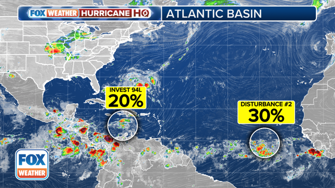
The National Hurricane Center is noting two disturbances that we’ll watch, although the odds of development are currently low for both of them.

The tropical weather outlook for the Atlantic Basin.
(FOX Weather)
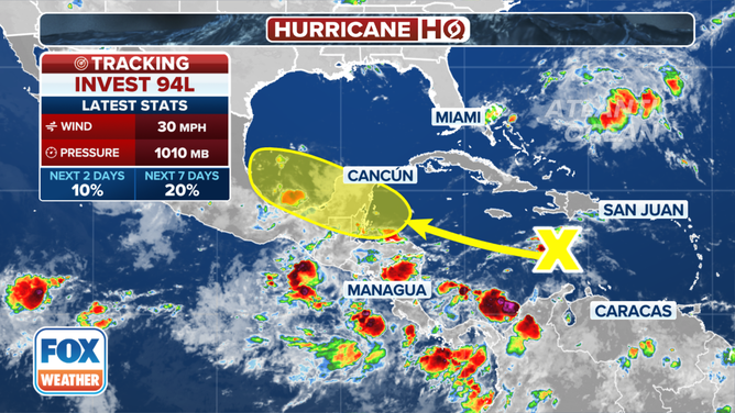
Disturbance No. 1 is speeding through the central Caribbean. They’ve officially tagged this system Invest 94L. The disturbance is forecast to slow down as it gets near Central America about Friday. At the same time, a bubble of benign upper-level winds is predicted to be in the general area. Light winds aloft are generally conducive to tropical development.
Extra strong winds typically blow across the eastern and central Caribbean this time of year – a phenomenon known as the Caribbean Low-Level Jet. The jet is caused by the acceleration of air between the mountains of the Caribbean islands to the north and South America to the south. It typically reaches its summer peak in July. The fast-moving air often inhibits the development of tropical systems until they move closer to Central America.
Disturbance No. 1's window of opportunity for organization is very short because the system will quickly run into land, so the National Hurricane Center is keeping the chances of it developing into at least a tropical depression in the low category.
In any case, the disturbance will bring heavy rain to the mountainous areas of Central America and southern Mexico. Development is also possible when the system moves across the extreme southern Gulf of Mexico over the weekend. High pressure across the southern U.S. will prevent the disturbance, whatever form it's in, from turning north.

Invest 94L is forecast to move into the Gulf of Mexico.
(FOX Weather)
Disturbance No. 2 moved off Africa over the weekend and is making its way across the tropical Atlantic. The system is quite far south and is embedded in the semi-permanent band of disturbed weather just north of the equator, called the Intertropical Convergence Zone. If it's going to develop, the disturbance will have to lift north and separate from nearby disturbed weather.
Forecasts for undeveloped systems are always iffy. But we’ll watch this one carefully because a number of computer predictions show a better-developed system near the islands late in the weekend or early next week. Upper-level winds are forecast to be somewhat supportive of development in the vicinity of the islands about that time.
In any case, the National Hurricane Center is keeping the odds in the low category due to the uncertainty factors including nearby Saharan dust. Due to the system’s low-latitude track, however, it might duck under the core of the dust cloud.
Everyone in the eastern Caribbean islands should plan to stay informed over the weekend.

The outlook for Disturbance No. 2 in the Atlantic.
(FOX Weather)
Why do conducive conditions matter?
Conducive conditions refer to a combination of factors that enable tropical systems to develop: warm ocean waters, supportive upper-level winds and a moist atmosphere. When these elements come together, disturbances can develop a well-defined circulation, which is the first step toward intensification.
The Caribbean Low-Level Jet
The Caribbean Low-Level Jet is an atmospheric phenomenon characterized by strong winds blowing across the eastern Caribbean during the summer months. This channel of strong air forms due to the air being squeezed between the large and mountainous Caribbean islands to the north and South America to the south. The jet typically reaches its peak strength in July and plays a significant role in inhibiting the development of tropical systems until they move into the western Caribbean closer to the Central American continent. The average location of the Bermuda high over the Atlantic changes later in the summer, as does the temperature contrast from south to north across the Caribbean. These changes are believed to be key to the relaxation of the Caribbean Low-Level Jet after July.
Intertropical Convergence Zone (ITCZ)
The Intertropical Convergence Zone (ITCZ) is a belt of low pressure near the equator where trade winds from the Northern and Southern Hemispheres come together. This convergence causes uplift of warm, moist air, resulting in a band of thunderstorm activity and heavy rainfall. Tropical systems often form within or migrate through this zone due to its favorable conditions for thunderstorm and cloud development.
Editor's note: Portions of this story were written using Artificial Intelligence.