Bryan Norcross: Unusual June development in the tropical Atlantic is looking more likely
The National Hurricane Center now has the development chances for Invest 95L in the high range. On the current schedule, it would arrive at the Caribbean islands around late Sunday or Monday.

FOX Weather is your Hurricane HQ, streaming free 24/7.
(FOX Weather)
Updated at 7 a.m. ET Thursday
Before 2021, it was rare to have a June tropical storm develop in the Atlantic east of the Caribbean. In the last three years, however, it’s happened three times, and Bonnie tried hard in 2022 but didn’t get going until it got to the western Caribbean. Now, multiple computer forecast models are showing similar development from a disturbance midway between Africa and the Caribbean islands.
The disturbance, officially named Invest 95L, is far enough south that it’s so far avoiding the moisture-sucking large cloud of Saharan dust sprawled across the tropics to its north. The circulation around the potential tropical system will be able to draw moisture from the south and push the dust away, if the computer forecasts are correct.
The National Hurricane Center now has the development chances for this system in the high range. Though remember, those odds are just for the development of a tropical depression. On the current schedule, it would arrive at the Caribbean islands around late Sunday or Monday.
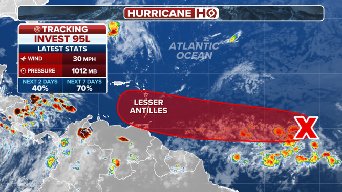
The outlook for Invest 95L in the Atlantic.
(FOX Weather)
Besides holding off the substantial dust to the north, the system will also have to separate itself from the quasi-permanent band of disturbed weather called the Monsoon Trough. Many of the computer projections predict that the disturbance will be able to do that, but we've often seen the process of a disturbance evolving into an independent, standalone system slow down development.
Yesterday, a number of the computer simulations showed the system developing into a hurricane next week. Today, the various computer models mostly show a weaker system heading west. If the storm ends up in the Caribbean, which is the consensus, it would be pretty unusual for the system to strengthen, although it has happened. Strong east-to-west winds called the Caribbean Low-Level Jet usually peak in July impeding development.
Long-range projections are all over the place and are not worth much. The future track of the system will likely be highly reliant on how strong it gets and when. Stronger storms tend to turn north sooner, though that’s not 100%.
The disturbance is not expected to develop quickly, but the upper-level winds over the Atlantic east of the islands are forecast to become unusually conducive to development about the time the system arrives in that vicinity over the weekend.
For now, there is nothing to do but stay informed, especially in the Caribbean islands. Forecasts for systems that have not yet formed are subject to large day-to-day changes, so don’t lock in on any particular prediction – especially the inflammatory models being spread on the internet. Stick with authoritative sources.
There is some indication that more robust disturbances will move off Africa behind Invest 95L. We'll watch for that, of course.
Why are the tropics suddenly waking up? One reason is related to a pulse that slowly moves around the Earth called the Madden-Julian Oscillation (MJO). The pulse isn't especially strong at the moment, but it is located in exactly the right position to enhance tropical development in the Atlantic. That's at least part of the answer.
Invest 94L
There is also a disturbance of interest moving through the Caribbean. This one is officially called Invest 94L. It's heading toward Central America and southern Mexico, bringing the possibility of heavy and dangerous rainfall. The National Hurricane Center is giving this system a low chance of developing. If it does, it would likely be in the far western Caribbean or the extreme southern Gulf of Mexico, if the system survives its trek across land. A pocket of supportive upper-level winds is forecast in that area.
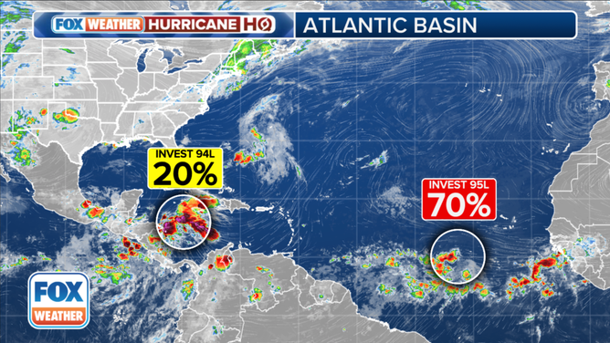
The tropical weather outlook for the Atlantic Basin.
(FOX Weather)
On the current schedule, the disturbance will impact Central America and move into the southern Gulf over the weekend. High pressure across the southern U.S. should keep the system well to the south.
The thunderstorm-supporting MJO pulse is forecast to move away after the first week of July, so things might calm down around then. Although it's likely there are other factors at play as well. Stay aware and stay informed.
Key points expanded
Monsoon Trough: The Monsoon Trough is an elongated region of low pressure that forms over the tropical oceans. "Monsoon" means "seasonal." Something that occurs in a certain season of the year. The Monsoon Trough is characterized by a convergence of winds from the Northern and Southern Hemispheres, which leads to the development of thunderstorms and heavy rainfall. This trough is an important factor in the formation of tropical systems since it provides a conducive environment for the development of low-pressure systems. It’s related to, but slightly different from the Intertropical Convergence Zone (ITCZ).
Caribbean Low-Level Jet: The Caribbean Low-Level Jet is an atmospheric phenomenon characterized by strong winds blowing across the eastern Caribbean during the summer months. This channel of strong air forms due to the air being squeezed between the large and mountainous Caribbean islands to the north and South America to the south. The jet typically reaches its peak strength in July and plays a significant role in inhibiting the development of tropical systems until they move into the western Caribbean closer to the Central American continent. The average location of the Bermuda high over the Atlantic changes later in the summer, as does the temperature contrast from south to north across the Caribbean. These changes are believed to be key to the relaxation of the Caribbean Low-Level Jet after July.
Madden-Julian Oscillation (MJO): The Madden-Julian Oscillation (MJO) is an eastward-moving pulse of cloud and rainfall near the equator that typically takes 30 to 60 days to circumnavigate the Earth. This pulse influences weather patterns around the globe, including tropical development. When the MJO is active in a particular region, it enhances the likelihood of storm formation by providing increased moisture, favorable wind patterns and atmospheric instability, which supports thunderstorm development. The MJO's position can significantly impact the activity levels in the tropical Atlantic, either promoting or inhibiting storm development based on its phase.
What is an invest?: An "invest" is an area of disturbed weather that National Hurricane Center meteorologists are investigating for potential development into a well-defined tropical system. The term "invest" is used along with a number (like Invest 95L) to identify and track these systems. It does not mean that the system will definitely develop into a tropical storm or hurricane, but it indicates that it has the potential to do so and is being monitored with additional computer forecast models.
Editor's note: Portions of this story were written using Artificial Intelligence.