Bryan Norcross: Atlantic disturbance well on its way to developing into depression or Tropical Storm Beryl
Three systems look to be on their way to affecting land areas, although for the foreseeable future they won't be a threat to the U.S. or surrounding areas.

FOX Weather is your Hurricane HQ.
(FOX Weather)
Updated at 9:30 a.m. ET Friday
The tropics are looking more like August than June.
Three systems look to be on their way to affecting land areas, although for the foreseeable future they won't be a threat to the U.S. or surrounding areas. The best developed of the three, officially called Invest 95L, is steadily organizing just south of the large Saharan dust plume that covers much of the tropical Atlantic.
Invest 95L
The well-developed tropical disturbance midway between Africa and the Caribbean has a reasonably well-developed circulation, though thunderstorms are still disorganized. It doesn't qualify to be designated a tropical depression … yet. But it's close. Winds in the broad circulation are estimated to still be below 40 mph, but increased organization will come with increased top winds, and that's what's expected.
The strong consensus among the computer forecast models is that the system will develop into at least a tropical storm by the time it reaches the Caribbean islands. It's on track to cross the islands around Monday. Likely-Tropical Storm Beryl will be tracking through an atmospheric regime that is forecast to be unusually conducive to storm development for June.
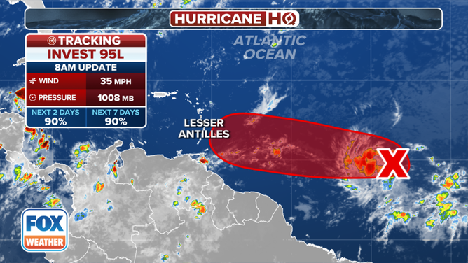
(Invest 95L doesn't qualify to be designated a tropical depression … yet. / FOX Weather)
Normally, this time of year, Saharan dust keeps a lid on development in the tropical Atlantic. This week’s systems have developed at such a low latitude, however, that they are ducking under the dust cloud just to the north. In fact, there is some evidence that the edge of the dust cloud can be conducive to development.
The National Hurricane Center has the odds of development of Invest 95L in the high category, but those odds only pertain to the possibility of it becoming a tropical depression. It wouldn't take much for the system to reach tropical storm strength, and the National Weather Service already has alerts issued for winds over 40 mph east of the Caribbean islands. It's not out of the question that the system could become a hurricane by the time it gets to the islands.
Everyone in the eastern Caribbean islands from Trinidad north to at least Guadeloupe needs to stay well-informed this weekend. On the current schedule, the system would impact the islands beginning on Sunday.
The system's track after it reaches the Caribbean is, to a significant degree, dependent on how quickly it intensifies. A stronger storm is more likely to bend farther north because it will be affected by dips in the jet stream or higher-latitude upper-level low-pressure systems. A weaker system is more likely to be driven west on the prevailing flow across the tropics.
Likely-Beryl is tracking at such a low latitude that it is most likely to head west in the Caribbean, at least for a while. Storms usually weaken or have trouble strengthening in the eastern Caribbean due to the acceleration of the east-to-west winds. Some of the computer forecasts show the system intensifying through the Caribbean, however, which introduces more track uncertainty for the middle of next week and beyond.
For now, high pressure over the southeastern US appears most likely to hold likely-Beryl well to the south, at least well into the Caribbean. But it's too early to be sure of the long term. Forecasts for systems that have yet to develop or are just organizing intrinsically have much larger errors than those for well-developed storms.
Next Atlantic system
The National Hurricane Center is also making note of another disturbance right behind likely Beryl. We’re calling this one Disturbance #3. It's at an even lower latitude, so it may well bypass the dense plume of Saharan dust to the north, as well. The atmospheric pattern ahead of this one does not seem as conducive to development as what likely-Beryl is going to encounter, but the tracks should be similar.
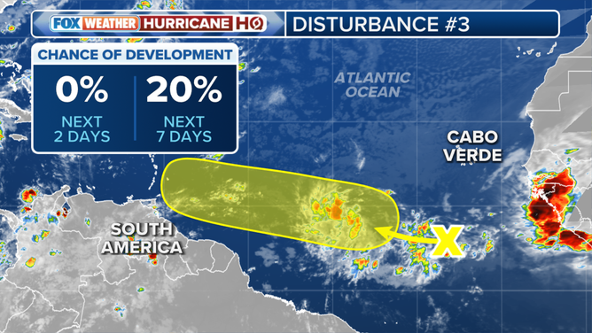
(The outlook for Disturbance No. 3 in the Atlantic. / FOX Weather)
The disturbance, whatever form it takes, will likely move through the islands into the Caribbean around the middle of next week. For now, the National Hurricane Center has the chances of this system becoming at least a tropical depression in the low category.
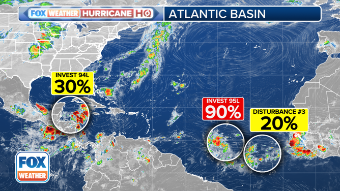
(The tropical weather outlook for the Atlantic Basin. / FOX Weather)
In the western Caribbean
The same weather pattern that produced Tropical Storm Alberto has set up over Central America and the Western Caribbean. A broad area of low pressure will pull a tropical disturbance out of the Caribbean into a somewhat conducive environment for development in the extreme southern Gulf of Mexico.
The National Hurricane Center is officially calling this system Invest 94L. They have the chances of the disturbance becoming at least a tropical depression in the southern Gulf in the low category. If it happens, it would likely be on Sunday.
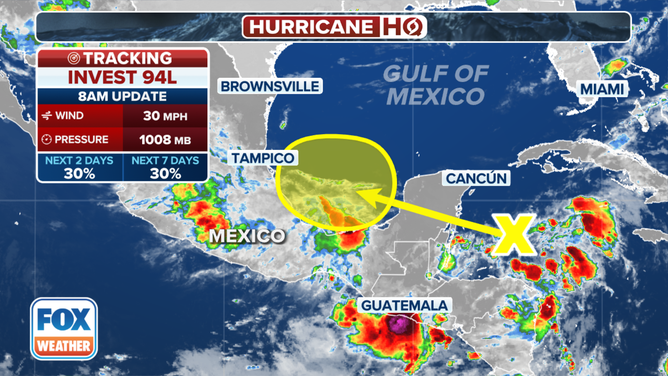
(Invest 94L is forecast to move into the Gulf of Mexico. / FOX Weather)
The biggest threat from the system appears to be the continuing very heavy rain in Central America and Mexico.
Coming off Africa
Another disturbance appears ready to move off the African coast. The weather pattern over the tropical Atlantic is evolving, however. So it's too early to know how it might develop.