Bryan Norcross: Unusual Tropical Storm Beryl forecast to become hurricane before reaching Caribbean islands
If Beryl reaches hurricane strength, which looks very likely, it will only be the second hurricane in the record book to take a track in June anything like the one forecast. The previous storm was a damaging Category 1 that hit Trinidad in the extraordinarily busy hurricane season of 1933.

FOX Weather is your Hurricane HQ.
(FOX Weather)
Updated 8:30 a.m. ET Saturday
Tropical Storm Beryl formed from the disturbance we've been following across the tropical Atlantic. This is a confluence of unusual events for June. The storm is tracking at an uncommonly far south latitude, which is allowing it to avoid the Saharan dust plume and cooler water to the north. The atmospheric pattern it will traverse over the next two days is forecast to be extremely conducive to tropical development – again unusual for June.
If Beryl reaches hurricane strength, which looks very likely, it will only be the second hurricane in the record book to take a track in June anything like the one forecast. The previous storm was a damaging Category 1 that hit Trinidad in the extraordinarily busy hurricane season of 1933.
Hurricane watches are in effect for Barbados because it is first in Beryl’s possible path, but additional alerts will be issued for other islands today and tomorrow. Beryl is not a large storm, so a slight deviation in its track changes which islands get what impacts. Preparations in the potentially affected islands should be underway.
The current schedule takes the center of Beryl into the Caribbean between Grenada and Martinique on Monday. The winds will be significantly stronger and more extensive north of where the center crosses the islands.
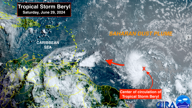
Tropical Storm Beryl formed from the disturbance we've been following across the tropical Atlantic.
(NOAA)
After Beryl tracks into the Caribbean, the forecast becomes fuzzier. The intensity and the track are interrelated. The sooner Beryl turns into a hurricane, the more likely the track will bend to the north, at least to some degree.
Historically, many June and July storms have weakened in the eastern Caribbean because of the hostile accelerating wind flow that is common there. Current computer forecast models show no impact on Beryl’s intensity from that phenomenon, however. In fact, a number of the computer predictions show a stronger storm crossing the islands than shown in the explicit NHC forecast.
Remember the rules. We always prepare for a storm at least one category higher than is explicitly forecast. And we expect forecasts for just-developing storms to change since they have higher intrinsic errors.
Beryl is likely to be in the Caribbean for a few days, at least. The question is, what will happen when the storm reaches the western part of the Caribbean Sea? It depends on how strong the storm is and where it’s located several days from now, which is unknowable, of course. Could it eventually track into the Gulf? Yes. Although it’s not worth thinking about. There are too many variables in play.
The consensus at the current time is that Beryl will weaken when it reaches the central and western Caribbean as it moves away from the pristine atmospheric bubble over the eastern islands. This is why you see the top winds decreasing at the end of the forecast period.
For now, the threat is to the Caribbean islands south of Guadeloupe. Once the storm gets into the eastern Caribbean, we should have a better idea about its future track. The storm appears likely to be well-developed by that time meaning forecasts should be more accurate.
Next Atlantic system
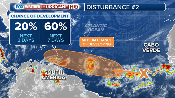
Another tropical disturbance, which the National Hurricane Center has tagged Invest 96L, is following on Beryl's heels. It's even farther south with plenty of warm water ahead. The upper-level winds are not expected to be as quite as conducive for tropical development as they were for Beryl, but computer model forecasts show a significant system passing through the eastern Caribbean islands mid next week – about 48 hours after Beryl. Yes… that’s unusual for any time of year, and off the charts for June.
(FOX Weather)
The National Hurricane Center is giving this disturbance a medium chance of developing into a tropical depression over the next week. If it cranks up further, it will be named Tropical Storm Chris. In any case, it will bring gusty squalls to the eastern Caribbean islands. As with Beryl, it’s too early to know which islands will get the strongest winds.
In the southern Gulf
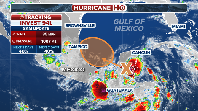
A third disturbance, which the National Hurricane Center has tagged Invest 94L, will move into the extreme southern Gulf of Mexico tomorrow where it will have a brief chance to develop into an organized system before moving ashore in Mexico. The system already has a reasonably well-defined circulation.
(FOX Weather)
If it had more time over the Gulf water, it would likely develop. But since the window is short, the National Hurricane Center is giving it a medium chance of developing into at least a tropical depression.
The big threat is from continued heavy rain causing flooding and mudslides over Central America and parts of Mexico whether this system develops further or not.