Bryan Norcross: Extreme hurricane threat for some Caribbean islands
Hurricane Beryl has the potential to be a catastrophic event if its relatively narrow band of intense winds impacts a populated island.

FOX Weather is your Hurricane HQ.
(FOX Weather)
Updated at 9:45 a.m. ET on Sunday, June 30, 2024
You would think it was August. Exceptional and record-setting Hurricane Beryl is charging toward the southeastern Caribbean islands. Hurricane Warnings have been issued for the islands where the threat is the highest. On the current schedule, the weather will deteriorate late Sunday, and the maximum impact will be on Monday.
A Hurricane Warning does not mean that hurricane conditions will for sure occur. It means that there is a danger that they could occur based on the best information available. Therefore, full hurricane preparations are required where the warnings are posted.
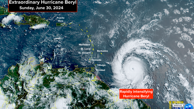
A satellite image of Hurricane Beryl.
(NOAA)
Now that Hurricane Beryl is well organized, and the steering high-pressure system to the north is strong and stable, we can have higher confidence in the track. Hurricane Warnings extend from Grenada in the south to St. Lucia in the north, plus Barbados. Nearby islands will also feel significant effects. Since Beryl is a small hurricane in diameter, the worst of the extreme winds will likely not impact more than one or two islands. But it's too early to know the exact maximum impact zone.
This is an extraordinary and unprecedented event for this time of year. Barbados and the islands of the southeast Caribbean are no strangers to hurricanes. But only once has a hurricane traversed this zone in June in the record book. That was in 1933, which ranks as one of the busiest hurricane seasons on record, and it was a Category 1.
The upper-level wind pattern is extremely conducive for Beryl to strengthen as it approaches the islands and passes into the Caribbean. By late Tuesday, however, it will be facing a bit of a headwind, which is why the National Hurricane Center is showing some weakening on days 4 and 5 in the forecast.
This may be a harbinger of things to come, or it might be something more like a freak event that Beryl and the system that's following it (called Invest 96L) formed just below the Saharan dust plume. Normally, the dust impedes development of systems as they move off Africa this time of year.
Confidence is high that Beryl will track across the central Caribbean until midweek and not impact Puerto Rico or the Virgin Islands in a significant way. The track’s bend to the north is due to a dip in the jet stream moving off the U.S. East Coast, which will pull it north. High pressure will then build across the southern U.S., which should push Beryl south again as it moves into the western Caribbean.
After that, things get fuzzier. The odds favor high pressure holding it to the south of the U.S. But if the high pressure moves out of the way too soon, there is some chance the storm could slow and possibly turn into the Gulf. There are too many variables, including the speed of the storm, its intensity and the movement of the blocking high to predict with confidence what will happen at the end of the week.
For now, our concern is for the affected Caribbean Islands. Hurricane Beryl has the potential to be a catastrophic event if its relatively narrow band of intense winds impacts a populated island. With luck, the strongest winds will find a gap between the islands, which sometimes happens.
Next in the Atlantic
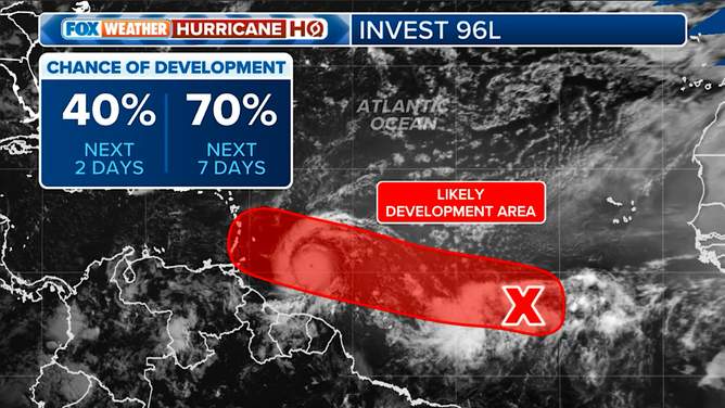
The latest on Invest 96L.
(FOX Weather)
The system, officially called Invest 96L, is two days behind Beryl. If this system attains winds of 40 mph, it will be named Tropical Storm Chris (or possibly Debby, depending on what happens in the Gulf). Potential Chris will find a similarly conducive environment to the one that allowed Beryl to get so strong, though maybe not as pristine. The question is, how soon can potential Chris get organized to take advantage of the supportive atmospheric regime?
On the current schedule, potential Chris or whatever it is, would impact the eastern Caribbean islands about Wednesday. Because the disturbance is still disorganized, the strength of the system at that time is unknowable.
If Beryl coming through the islands as a Category 3 or higher hurricane is extraordinary, the idea of two storms in two days on similar tracks is insane. We'll see.
In the Gulf
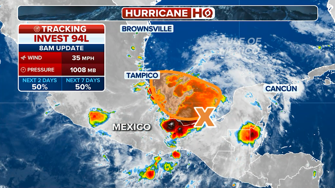
The latest on Invest 94L.
(FOX Weather)
The system the National Hurricane Center has been calling Invest 94L has a decent chance today to turn into a tropical depression or tropical storm in the southern Gulf of Mexico. The system is reasonably well-developed, but it will be operating so close to land and have such a short window over the water that it may or may not have time to organize.
The threat with this system continues to be to Mexico and Central America, where extreme amounts of rain have fallen over the past few weeks.
This flurry of tropical activity is at least partially related to a pulse called the MJO that propagates around the Earth every 30-60 days. When it gets to just the right position, it enhances the likelihood of storms developing. The current pulse is relatively weak, but it is positioned for maximum Atlantic storm-enhancing impact. The pulse will move on as we get into July. Hopefully, things will calm down, but let’s not count on it.