Bryan Norcross: Sara to fade away by tomorrow as hurricane season winds down
All indications are that hurricane season for the U.S. and surrounding areas is over. An oddball system can always develop out in the Atlantic out a non-tropical disturbance, but the odds of that happening get lower every day.

FOX Weather is your Hurricane HQ.
(FOX Weather / FOX Weather)
Updated: 10:30 a.m. ET, Sunday, Nov. 17.
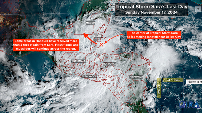
Tropical Storm Sara will move inland across Belize today and will likely come apart over the Yucatán Peninsula of Mexico tomorrow. The remnants will move into the Gulf of Mexico. An approaching cold front and its associated dip in the jet stream will pull ex-Sara's moisture toward the northern Gulf Coast where it will be pushed toward Florida through midweek.
The combination of a robust cold front and tropical moisture can produce strong thunderstorms with heavy rain. The combo system is forecast to initially impact Louisiana, where up to 3–5 inches of rain are possible. Then the front pushes the band of thunderstorms across Alabama and the Florida panhandle on Tuesday and then down the state on Wednesday.

Tropical Storm Sara will likely dissipate in the Yucatán Peninsula of Mexico tomorrow. The storm's remnants will move into the Gulf of Mexico.
(National Hurricane Center / NOAA)
Storms could be especially strong, especially across the northern Gulf Coast and in North and Central Florida. We’ll watch for the possibility of some tornadoes in the strongest cells as well.
Sara will be done with Central America by tomorrow, but the flooding will continue as two to more than three feet of rainfall drains downhill. As is often the case, tropical moisture and mountainous terrain are a deadly combination.

Tropical Storm Sara will move inland across Belize Sunday and likely come apart over the Yucatán Peninsula of Mexico Monday.
(NOAA)
All indications are that hurricane season for the U.S. and surrounding areas is over. An oddball system can always develop out in the Atlantic out of a non-tropical disturbance, but the odds of that happening get lower every day.
A cold front pushing through Florida will usher in a winter weather regime and a clear change in the season. Enjoy the break.