Bryan Norcross: Possible Tropical Storm Rafael coming out of the Caribbean next week
The National Hurricane Center gives the new system an 80% chance of developing into at least a tropical depression. If and when winds in the circulation reach at least 40 mph, it will be named Tropical Storm Rafael.
Disturbance in Caribbean likely to become tropical depression next week
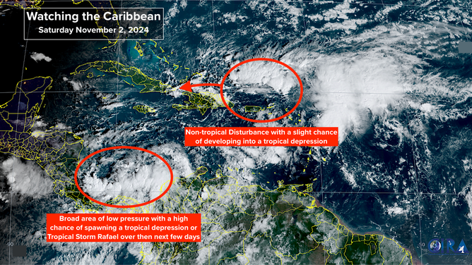
A broad area of low pressure is expected to become at least a tropical depression early next week as it slowly moves into the northwestern Caribbean.
A broad area of low pressure over the southern Caribbean Sea is forecast to spawn an independent low-pressure system on its eastern flank. That disturbance looks likely to rotate north and west, so it's in the vicinity of Jamaica early in the week.
The National Hurricane Center gives the new system an 80% chance of developing into at least a tropical depression. If and when winds in the circulation reach at least 40 mph, it will be named Tropical Storm Rafael.
There is a general consensus in the computer forecast model projections that the system will be at or near tropical storm strength when it reaches the southern Gulf on Wednesday or Thursday.
A dense plume of tropical moisture is forecast to rotate north with the potential storm. This will enhance the flooding threat on the Caribbean islands west of Puerto Rico beginning Monday. Some of the moisture could reach South Florida by midweek.

Watching the Caribbean.
(FOX Weather / FOX Weather)
Once the system is in the Gulf, the forecast gets fuzzy. The steering currents are predicted to weaken significantly, which always adds uncertainty to the forecast.
If the system stays relatively weak, it looks more likely to drift to the west, perhaps toward the Mexican coast. If it's on the stronger side, however, it could continue north toward some part of the U.S. Gulf Coast.
The storm will meet a lot of dry air in the Gulf of Mexico, and the upper-level winds are forecast to remain hostile across the northern Gulf and the Southeast. So, even if possible-Rafael is able to strengthen in the southern Gulf, a significant storm at the coast looks unlikely, based on what we know now.
If the system ever reaches the coast, on the current schedule, that would happen around next weekend.
Obviously, we're going to have another week of watching the tropics, though the odds of a significant storm impacting the U.S. appear to be low. Forecasts for a week from now are always fuzzy, of course, so stay tuned.

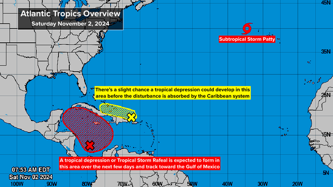
Atlantic Tropics Overview
(FOX Weather / FOX Weather)
NEAR PUERTO RICO, a combination of an upper-level disturbance and an old front is producing a large area of disturbed weather. Some heavy tropical downpours will affect the northeastern Caribbean islands for the next couple of days as the system tracks to the west. Next week, it will likely be absorbed by the developing disturbance in the Caribbean.
The National Hurricane Center is giving this system a slight chance of becoming a tropical depression over the next couple of days. Even if that should happen, however, it wouldn't change the forecast weather.
IN THE NORTH ATLANTIC, Subtropical Storm Patty has formed from a large non-tropical low-pressure system. It's called a subtropical storm because its energy is sustained by a combination of heat from the ocean and cold air left over from its non-tropical status.
The system will move over or near the Azores islands tomorrow and weaken as it heads toward Portugal or northwestern Spain. No significant impacts are expected there, however.
