Bryan Norcross: Caribbean disturbance forecast to become Hurricane Rafael and move into the Gulf of Mexico
There is a reasonable consensus in the various computer forecast models that likely-Hurricane Rafael will reach the Gulf, but then things get fuzzy.

FOX Weather is your Hurricane HQ.
(FOX Weather / FOX Weather)
Updated 9:30 a.m. Monday, November 4, 2024
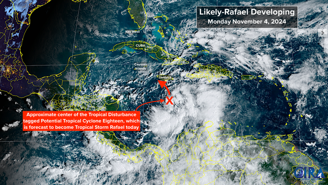
The Caribbean disturbance we've been following is still in the organizing stage. It has a broad circulation center and an irregular shape. The National Hurricane Center has designated it Potential Tropical Cyclone Eighteen, which just means it's likely to develop, so watches and warnings are issued for land areas ahead.

Satellite imagery showing the center of the Tropical Disturbance which is forecast to become Tropical Storm Rafael.
(NOAA)
The disturbance is forecast to become Hurricane Rafael tomorrow. The storm will impact Jamaica tonight and track near the Cayman Islands during the day Tuesday. If the system gets organized today as forecast, it could be a strong tropical storm or hurricane by late tomorrow, so Tropical Storm Warnings are in effect for Jamaica and a Hurricane Warning for the Caymans in anticipation of the strengthening process.
Atmospheric conditions over the northwest Caribbean appear conducive for steady strengthening over the very warm waters. The current track takes the storm over the western end of Cuba and into the Gulf of Mexico at hurricane strength on Wednesday.
There is a reasonable consensus in the various computer forecast models that likely-Hurricane Rafael will reach the Gulf, but then things get fuzzy. The steering currents are forecast to break down, so movement from Thursday into Friday should be slow. In addition, upper-level winds are forecast to become increasingly hostile.
The National Hurricane Center reflects these changes in the atmospheric environment by forecasting the storm to slowly weaken as it drifts in the central Gulf.
Forecasts for slow-moving storms are always problematic. In this case, some computer forecasts take it west toward Mexico or Texas, and other predictions show it arcing farther east between Louisiana and the Florida Panhandle. In any case, if the storm makes it to the coast, it will be in a weakening phase, based on what we know now.
Obviously, everyone on the Gulf Coast from Texas to Florida should stay informed this week. The forecast will likely be adjusted as the system organizes, strengthens, and becomes better defined.
In any case, with likely-Rafael in the Caribbean and moving into the Gulf, and a strong high-pressure system off the Southeast coast, winds will be quite gusty over the southern half of the Florida Peninsula and the Keys Tuesday, Wednesday, and maybe into Thursday.
In addition, likely-Rafael will pull rich tropical moisture north with higher chances of rain spreading up the peninsula beginning Tuesday.
If Rafael tracks up the right side of the National Hurricane Center cone as some computer forecasts indicate, stronger winds and storm surge could affect the Keys and the southern half of the Florida West Coast Wednesday into Thursday. The storm is just forming, so we'll see how the forecasts evolve.
Even though it seems like there are similarities, this is not a Hurricane Helene scenario. There may well be effects along some parts of the Florida coast, so we have to stay aware. But this storm is very unlikely to come ashore as a hurricane, wherever that happens.

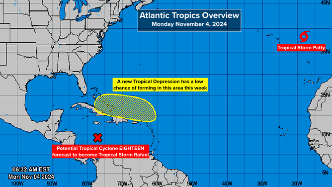
Potential for new Tropical Depression to form in the Northern Caribbean.
(NOAA)
North of the Caribbean islands, the National Hurricane Center is identifying a potential development area where there's a low chance of a tropical depression forming over the next several days. The system will most likely track near or over the islands as a moisture surge is trapped under the high-pressure system off the Southeast coast.
Around the weekend, it could affect the southern Florida Peninsula. We'll keep an eye on it.
Off the coast of Portugal, Tropical Storm Patty is on its last legs. It is forecast to lose its tropical characteristics and weaken today.