Bryan Norcross: Slow-developing tropical system could organize in the Gulf this weekend
Initially, this sequence of events looks very similar to the process that created Helene, but the weather pattern across the northern Gulf and the Southeast U.S. will be completely different this time around.

Forecasters watching area that could threaten Gulf Coast
The National Hurricane Center is closely watching an area near Central America that could send a tropical system toward the Gulf Coast either late this week or early next week.
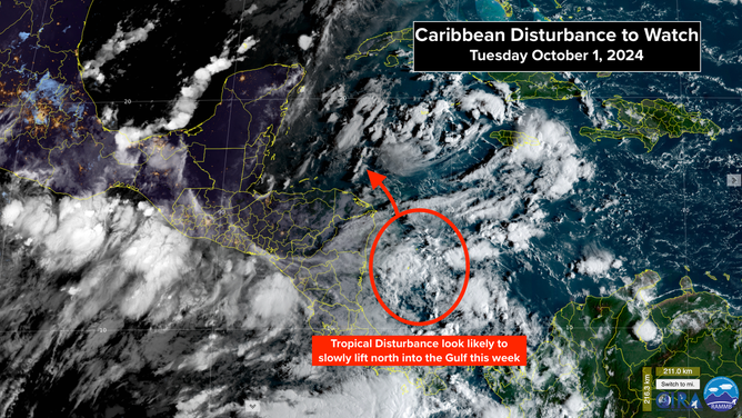
The tropical disturbance we've been following in the southwestern Caribbean Sea is still totally disorganized. It's on the edge of a large low-pressure system over Central America, which will eventually lift the disturbance north and into the Gulf of Mexico late in the week. Over the weekend, the system will have a chance to develop, and then things will get complicated.
Initially, this sequence of events looks very similar to the process that created Helene, but the weather pattern across the northern Gulf and the Southeast U.S. will be completely different this time around. A cold front and a band of hostile upper winds will keep the system, whatever form it takes, from getting very far north.
The various computer forecasts present a wide range of possibilities, from the system stalling and dying in the southwestern Gulf to developing into a storm and tracking toward Florida to two separate systems eventually forming. Many of the forecasts show a broad, disorganized disturbance, although others disagree and predict that the upper-level environment will be reasonably conducive to development, and the system will organize.
Caribbean Disturbance Outlook
(FOX Weather)
On the very loose current schedule, the disturbance will develop something of a circulation in the western Caribbean in the next couple of days, then slowly lift toward the Gulf. By Sunday morning, the consensus is that it will still be located over the Gulf waters, but the possible locations spread from one side of the Gulf to the other.
Broadly speaking, according to the various predictions, if the disturbance stays weak and diffuse, it is more likely to stall in the Gulf well into next week. On the other hand, if the system finds a pocket of atmosphere where it can spin up into a stronger storm, it is more likely to be directed toward Florida. But these are only two of the range of possibilities.
The initial steering comes from a high-pressure area over the Bahamas and Cuba. The south-to-north flow on that system's west side will push the disturbance north. Once it's in the Gulf, however, the steering flow becomes light.
Dips in the jet stream across the southern U.S. might deflect the system toward the eastern Gulf. The question is whether the dips are strong enough to grab it and whether the disturbance has developed enough of an organization to be grabbed. A weak system probably stalls, while a stronger system is more likely to be shoved toward somewhere in Florida.
The National Hurricane Center has the odds in the medium range that the disturbance will develop into at least a tropical depression over the next 7 days. You can see that the orange potential development zone covers a big part of the Gulf of Mexico and the northwest Caribbean.
For now, everybody from Louisiana to Florida near the Gulf Coast needs to stay informed. Nothing will happen fast. Hopefully, when the system develops a circulation, the models will settle down, and we can narrow the set of possibilities that we might see from this disturbance.
Atlantic Tropics Overview
(FOX Weather)
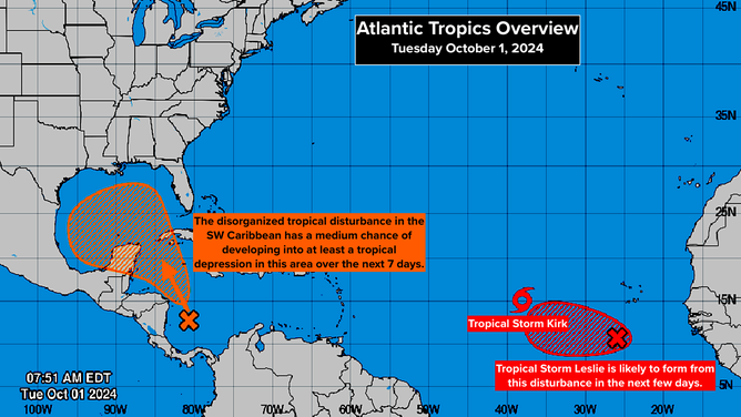
FAR OUT IN THE ATLANTIC: Tropical Storm Isaac and Tropical Depression Joyce have died out without threatening land.
Tropical Storm Kirk is forecast to become a strong hurricane, but it will turn north into the open Atlantic.
Another tropical disturbance, which the National Hurricane Center has tagged Invest #91L, is right behind Kirk. It's at a lower latitude, however, so it's not 100% certain that it will take the off-ramp into the open ocean so quickly.
The steering currents driving the disturbance west are quite weak over the tropical Atlantic, so it will take well into next week before it could remotely become a threat. Most computer forecasts predict this system will turn north like the others before it, but that's not 100%.