Bryan Norcross: Thoughts after Hurricane Milton
The fact that two hurricanes have impacted Florida in two weeks seems unusual. But it's actually not totally crazy. There are many years in the record book when one hurricane was followed by another in fairly short order.

Hurricane Milton leaves at least 4 dead in St. Lucie County, Florida
A tornado outbreak spawned by Hurricane Milton is being blamed for the deaths of at least four people in St. Lucie County, Florida. St. Lucie County Sheriff Keith Pearson said the victims were in Spanish Lakes Country Club Village in northern Fort Pierce, where a significant tornado moved through on Wednesday.
Updated Thursday 3 p.m. ET
Milton's wrath came in three phases yesterday and last night. During phase 1, intense outer bands produced unusually strong tornadoes as they swept from Southwest Florida to the Treasure Coast near Fort Pierce. The tornadoes were more energetic than normal because of the jet stream that was ripping across the hurricane.
Phase 2 was last night when Milton's circulation pushed storm surge over the barrier islands and into neighborhoods along the Gulf Coast south of the landfall point near Sarasota. Many of these communities had not recovered from Hurricane Helene. We still don't have a full picture of what happened along that coastline.
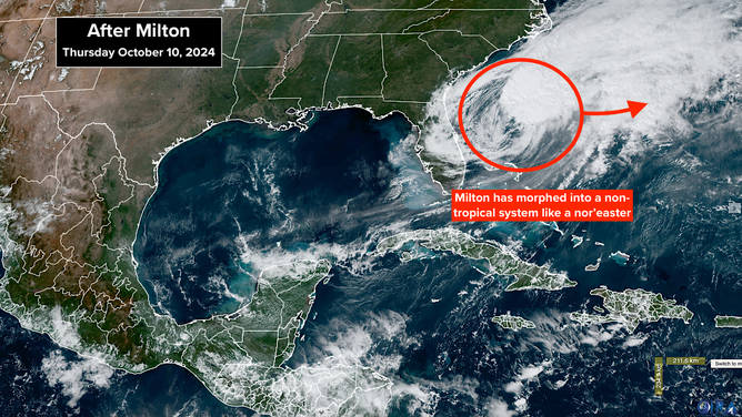
Phase 3 was the transit of the storm and its partial eyewall across the I-4 corridor from the Tampa metropolitan area through Orlando to the Atlantic coast.
The Tampa/St. Petersburg area was slashed by winds gusting over 100 mph and over a foot of rain. Fortunately for them, the center of the storm jogged just far enough south to keep the storm surge out of Tampa Bay. They lucked out by a distance of about 25 miles, which we will never be able to forecast more than a few hours in advance.
Satellite Image
Orlando was struck as well. Although the damage there appears to be less than it is in Tampa, St. Petersburg, and the surrounding area.
Overall, the National Hurricane Center and National Weather Service forecasts were excellent. Nobody got hit without warning, which was the goal. Everybody hopes we can get to the point where only people who end up getting hit are warned. But there will always be randomness in the path of storms, which requires "over warning" to be sure that nobody in harm's way goes unalerted.
The fact that two hurricanes have impacted Florida in two weeks seems unusual. But it's actually not totally crazy. There are many years in the record book when one hurricane was followed by another in fairly short order.
In 2004, Ivan, Frances, and Jeanne came in September after Charley hit Southwest Florida and Central Florida in August. In 1947 and 1948, two hurricanes tracked across South Florida each year, including two Category 4s. In 1954 and 1955, three hurricanes each year hit or passed near the Northeast and New England. And there are lots of other examples.
Hurricanes are, indeed, worse these days because the sea level is higher, there is more moisture in the air, and the Gulf water contains more energy to power storms. But the bigger point is, Mother Nature appears to be getting back to her old ways producing Florida hurricanes.
For the first 7 decades of the 20th Century, hurricanes were part of life in Florida. Then came a long period without significant storms. Even catastrophic Hurricane Andrew missed the economic core of South Florida. You could make a case that the lack of hurricanes encouraged development in many parts of the state. That development is being tested now that hurricanes seem to be coming back.
In Miami-Dade and Broward, new construction is built to tremendously high standards - a legacy of Hurricane Andrew. Let's hope the rest of the state learns from this round of hurricanes to better deal with the storms of the future.
LOOKING AHEAD: Nothing threatening is pending at the moment, although we'll keep an eye on the western Caribbean. The broad area of low pressure called the Central American Gyre is forecast to redevelop. As we've seen, independent tropical systems sometimes develop on the edges of that large circulation.