Bryan Norcross: System to watch for possible development late in the week
The consensus of the computer forecast models is that the disturbance will be in the vicinity of Puerto Rico or the surrounding islands at the end of the week.

Forecasters monitoring Invest 94L spinning across Atlantic for future development
Forecasters with the National Hurricane Center (NHC) are keeping their eyes on Invest 94L spinning over the eastern Atlantic which they say could develop into a tropical depression by the end of the week.
Updated at 10 a.m. ET on Sunday, Oct. 13, 2024
The Atlantic tropical disturbance that the National Hurricane Center has officially designated Invest 94L has a well-defined circulation, but no thunderstorms are rotating around its center. It's plowing west through a very dry atmosphere. Moderate upper-level winds are pushing what moisture it's carrying toward the south.
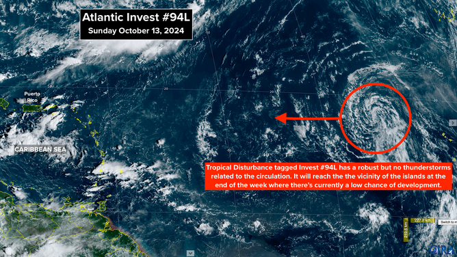
(RAMMB / CIRA / NOAA)
Around the middle of the week, the environment over the tropical Atlantic becomes slightly more conducive for development. The National Hurricane Center has the odds in the low range that at least a tropical depression will form as the system heads in the general direction of the northeastern Caribbean, but if the disturbance finds a pocket of moisture, something could spin up.
The consensus of the computer forecast models is that the disturbance will be in the vicinity of Puerto Rico or the surrounding islands at the end of the week. Some of the computer forecasts suggest that the atmospheric environment might be more supportive of a tropical depression or tropical storm after that time. The possible tracks and intensities are all over the place, however, so we'll just continue to monitor the situation.
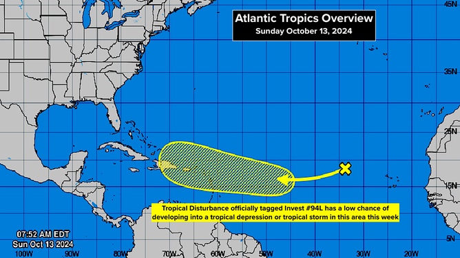
(NHC / NOAA)
A strong fall cold front will push through Florida this week. That should keep the continental U.S. protected from tropical systems at least through next weekend.
Everybody in the northeastern Caribbean should plan to stay informed this week until we see how this system develops.