Bryan Norcross: Watching for tropical development near the Caribbean at the end of the week
Development is unlikely for the next couple of days, but as the system arrives near or north of the northeastern Caribbean islands around Friday, conditions are forecast to be somewhat more conducive to development.

FOX Weather is your Hurricane HQ.
(FOX Weather)
Updated at 9:30 a.m. ET on Monday, Oct. 14, 2024
The tropical disturbance we've been following – officially tagged Invest 94L – continues to track west through an inhospitable atmosphere in the middle of the tropical Atlantic. The air is extremely dry, which has prevented thunderstorms from developing within the system's circulation.
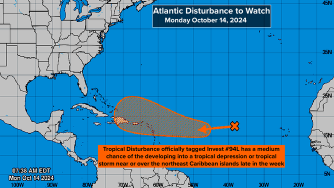
Invest 94L, a tropical disturbance, has the potential to reach the Caribbean, which is unusual for this time of year.
(National Hurricane Center)
Development is unlikely for the next couple of days, but as the system arrives near or north of the northeastern Caribbean islands around Friday, conditions are forecast to be somewhat more conducive to development.
It's pretty unusual for a tropical disturbance that originates over Africa to reach the vicinity of the Caribbean this time of year. Normally, the ocean waters are cooling, the upper-level winds become more hostile, and dips in the jet stream come along to scoop systems to the north. The extra-warm ocean and an elongated bubble of high pressure just north of the disturbance are contributing to the unusual track.
On the satellite image, you can see that some taller thunderstorms are trying to develop near the center of the otherwise dried-out, somewhat-disrupted circulation.
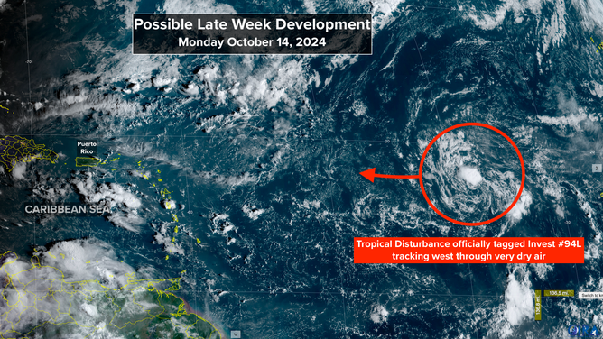
Satellite imagery shows Invest 94L taking an unusual track for this time of year towards the Caribbean.
(CIRA / RAMMB)
The National Hurricane Center is giving the system a medium chance of developing into at least a tropical depression about the time it arrives in the waters near or just north of Puerto Rico or the surrounding islands. There's a strong consensus among the computer forecast models that the disturbance will be in that vicinity about Friday, but the organizational possibilities range from just a moisture surge to a fairly strong system with a well-developed circulation.
After Friday, the steering currents are forecast to become light, so the system will drift near Puerto Rico, the Dominican Republic, Haiti or the southeastern Bahamas. Impacts from a tropical storm or hurricane on some of the islands can't be ruled out.
Anytime the steering flow is not well-defined, however, the track uncertainty increases, so for now, we'll watch for developments. Residents in Puerto Rico, the Virgin Islands, Hispañola, the southeastern Bahamas and the surrounding islands should stay well-informed this week.
There is no apparent threat to hurricane-weary Florida. A cold front across or near South Florida and a related dip in the jet stream developing over the Bahamas will likely keep tropical systems away from the state. But let's let the disturbance become better defined. Then we'll have higher confidence in the forecast.
As always, predictions about the future strength and track of undeveloped systems, just-developing systems or slow-moving systems have greater uncertainty and are subject to change.