Bryan Norcross: Tropical impacts possible this week in the islands and Central America
The National Hurricane Center gives Invest 94L a medium chance of developing into a tropical depression. It will jump to that status immediately if thunderstorms related to the circulation can fight off the dry air and organize themselves around the center.

FOX Weather is your Hurricane HQ.
(FOX Weather)
Updated at 10 a.m. ET on Tuesday, Oct. 15, 2024
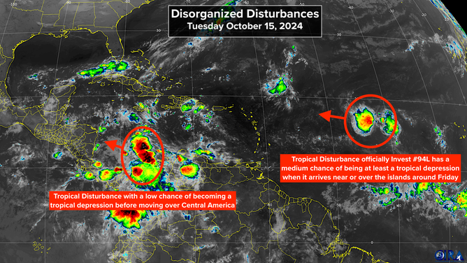
The well-formed disturbance in the central tropical Atlantic, officially named Invest 94L, is on course to reach the waters near or just north of Puerto Rico and the northeastern Caribbean islands around Friday. The system has been surrounded by a very dry atmosphere, which has impeded its development so far. It's had a reasonably well-defined circulation, and now some disorganized thunderstorms are persisting near the system.

Monitoring two tropical disturbances.
(CIRA / RAMMB)
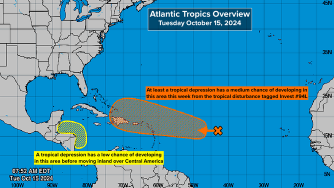
The National Hurricane Center gives it a medium chance of developing into a tropical depression. It will jump to that status immediately if thunderstorms related to the circulation can fight off the dry air and organize themselves around the center.
As the system continues west, the ocean waters warm, and the atmospheric environment is forecast to be reasonably conducive to development, so a tropical depression or tropical storm seems more likely than not to form.
It's a close call whether the system will have much of a direct impact on Puerto Rico and the Virgin Islands. Although even if the disturbance or depression passes to the north of the islands, a noticeable moisture surge will move through at the end of the week. The consensus of the computer forecasts is that eastern Cuba, Haiti, the Dominican Republic and the southern part of the Bahamas could be impacted over the weekend, though there is no sign of an especially strong storm.
There is no threat to Florida or the southeastern U.S.
The weather pattern over the Southeast, the Gulf of Mexico and Florida will be in wintertime mode for the next week or so. Extremely hostile upper-level winds will be blowing across the region, a couple of cold fronts will push through Florida, and dips in the jet stream over the Bahamas will pull any systems north that think about trying to reach Florida from the Atlantic.
Once the disturbance or depression passes Puerto Rico, the steering currents collapse, so the system will likely slowly maneuver near the Dominican Republic, Haiti, eastern Cuba or the southeastern Bahamas. Early next week, the Florida cold front and the jet-stream dip should sweep it north.
As always, forecast details can change for a system that is just developing or moving slowly. Systems that drift around near land are impossible to forecast with certainty very far in advance. So everybody from the southeastern Bahamas to the Virgin Islands should plan to stay informed of the latest developments to be sure the system doesn't suddenly spin up.

Tropical disturbances in the Caribbean and the Atlantic.
(National Hurricane Center)
In the Caribbean: A tropical disturbance moving through the central Caribbean Sea has a chance of developing into a tropical depression once it reaches the waters offshore of Nicaragua or Honduras. It looks likely to move on land almost immediately, which makes the window of opportunity for development short.
The National Hurricane Center gives the potential system a low chance of reaching depression status. It's forecast to track over Central America and produce flood-producing tropical rains.
Effects on Florida: Florida will feel the effects of these systems indirectly. Together, they will form a belt of low pressure from the Atlantic across the Caribbean. The contrast of the atmospheric pressure in that zone to the autumn high-pressure system driving the Florida cold front south will produce an extended period of windy weather on the east coast of Florida.
The northeast to east winds will drive the ocean water against the coast, which will push the tides higher than normal. Since we are in King Tide season, which already causes nuisance flooding at high tide, the situation is likely to be aggravated by days of onshore wind.
Remember, tidal flooding is saltwater, which is terrible for your car. If you have to drive through saltwater puddles, drive slowly to minimize the amount of salt that gets into the car's susceptible parts, then try to wash the underside of your car to get rid of the salt. You won't see the effects immediately, but eventually, parts can corrode.
Saltwater puddles look just like freshwater puddles, but they're there even when it hasn't rained.