Bryan Norcross: Watching for development of Invest 95L in the Caribbean before it makes landfall tomorrow
The consensus of the computer forecasts is that it won't get terribly strong, but it could become Tropical Storm Nadine just before coming ashore.

FOX Weather is your Hurricane HQ.
(FOX Weather)
Updated as of 9:07 a.m. ET on Oct. 18, 2024.
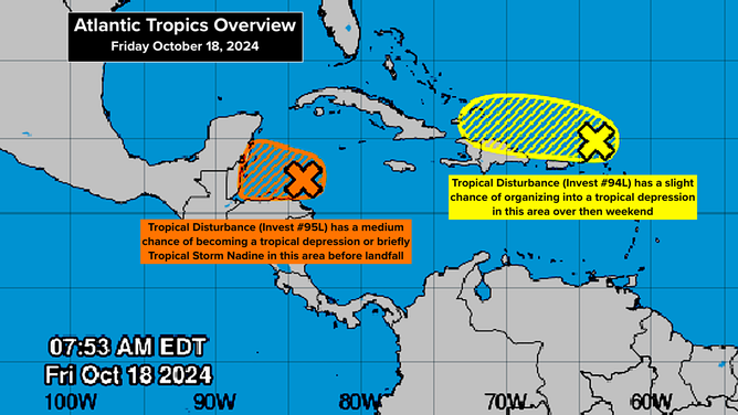
The broad tropical disturbance we've been following near the coast of Nicaragua and Honduras is now officially tagged Invest #95L. The system is forecast to track west today, just offshore of the northern coast of Honduras. It will head toward Belize and Yucatán, Mexico tonight.
The National Hurricane Center is giving the system a medium chance of briefly developing into a tropical depression or tropical storm before it makes landfall early tomorrow in Belize or nearby. The consensus of the computer forecasts is that it won't get terribly strong, but it could become Tropical Storm Nadine just before coming ashore.

An overview of tropical activity in the Atlantic Ocean as of Oct. 18, 2024.
(FOX Weather)
The strongest winds in the disturbance are north of the center, so areas north of the landfall point on the Yucatán Peninsula will get the strongest onshore winds tomorrow morning. Currently, the speeds are 30-35 mph. Some increase is possible before landfall.
Along the northern Honduras coast, in Belize, and in the Mexican state of Quintana Roo around Chetumal, residents should stay informed because the system could spin up at the last minute, just before landfall.
Peak effects begin overnight tonight and last into tomorrow, although it will continue to be quite breezy at the coast due to a cold front pushing in from the north behind the disturbance.
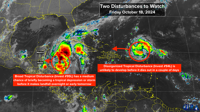
IN THE ATLANTIC: The tropical disturbance tagged Invest #94L will track through the waters just north of Puerto Rico and the Virgin Islands today. It will continue west to near Haiti or the southeastern Bahamas tomorrow then be wiped out by hostile upper winds about Sunday.
The National Hurricane Center now gives the disturbance a very slight chance of developing into a tropical depression before it dies out. The system's fast forward motion into a moderately dry atmosphere appears to be keeping it from organizing. Whether it becomes a depression or not, it will pull moisture over the mountainous islands, which could cause flooding of rivers and possibly mudslides.
None of the computer forecast models shows the disturbance organizing, but we'll keep an eye on it just to be sure.

Forecasters are watching two disturbances in the Atlantic Ocean.
(FOX Weather)
LOOKING AHEAD: There is no threat from either of these systems to Florida or the southeastern U.S. In fact, the jet stream is forecast to be in a wintertime mode across the northern Gulf of Mexico and Florida for the rest of the month, so we should be well protected.
ALONG THE FLORIDA EAST COAST: Beware of extra high tides through the weekend. What's called a Hunter's Supermoon is responsible for the King Tides, and the strong, persistent winds off the ocean will make the tides even higher. Try not to drive through high tide flooding. It's saltwater and bad for your car.