Bryan Norcross: The tropics suddenly perk up with Tropical Storm Nadine and perhaps Oscar
Nadine is forecast to die out over southern Mexico tomorrow, but gusty winds will continue along the coast, and heavy rain will persist.

Invest 94L rapidly becomes more organized, could become Oscar
Located north of Hispaniola, Invest 94L is rapidly organizing with now a 90% chance of development over the next two days. Should it develop, it would be named "Oscar."
Updated Saturday 7:00 a.m. ET
Fast-developing Tropical Storm Nadine will track across the Yucatán Peninsula today. Winds are estimated to be at least 40 mph on the north side of the circulation. The extra gusty winds extending north into the Gulf of Mexico are being caused by the contrast in pressure between the strong autumn high-pressure system over the eastern U.S. and Nadine's low pressure.
Some of the computer forecasts suggested that this would happen yesterday. Nadine will not be over water very long, so it will likely remain a minimal tropical storm up to landfall.
The strong winds will blow along the coast in the northern half of Belize and Mexico's Yucatán Peninsula north to Cancún. Heavy rainfall will fall across the region. The National Hurricane Center is forecasting 4 to 8 inches of rain with some areas receiving a foot.
Nadine is forecast to die out over southern Mexico tomorrow, but gusty winds will continue along the coast, and heavy rain will persist.
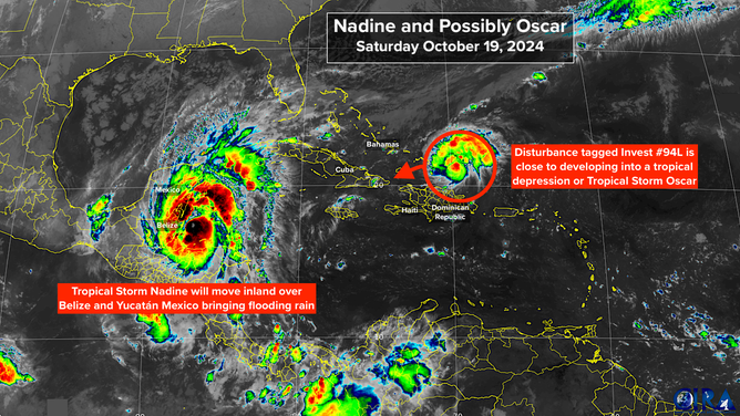
Map showing Nadine and possibly Oscar.
(FOX Weather / FOX Weather)
IN THE ATLANTIC: The tropical disturbance we've been following - officially Invest #94L – looks to be finally developing an organized circulation, so a tropical depression could form any time. The National Hurricane Center has boosted the odds that that will happen into the high range. Winds on the north side of the system appear to be just under tropical storm strength of 40 mph, but if it fully organizes, it won't take much to become Tropical Storm Oscar.
The system will track west, near the Dominican Republic and Haiti, then stall near or over the southeastern Bahamas or eastern Cuba. It is forecast to linger there into Monday, likely as a weak system. Hostile upper winds will move in and whatever's left of it will likely be swept to the north.
As the system meanders, it could bring heavy rain to the southeastern Bahamas, Haiti, and eastern Cuba before it dissipates or is scooped to the north. It should be out of the picture early next week.
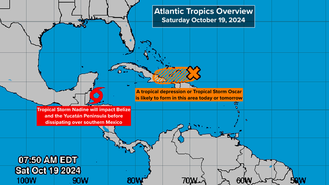
Atlantic Tropics Overview.
(FOX Weather / FOX Weather)
LOOKING AHEAD: Once these two systems leave the scene, the tropics look to go on hiatus for the rest of the month. A few times this year, we've talked about the pulse that slowly moves around the Earth alternately enhancing and suppressing tropical activity called the MJO. It was in an enhancement phase in late September and early October, and we got Helen and Milton. Now it's forecast to be in suppression phase through Halloween.
We can't rule out tropical issues developing in November, of course. Remember Hurricane Nicole in 2022 that hit Northeast Florida. Hopefully the jet stream pattern, which is currently blasting hostile winds across the Gulf and Florida, will continue. We'll see. But in a couple of days, we'll get a breather.