Bryan Norcross: Watching for tropical development in the Gulf beginning this weekend
The National Hurricane Center has the odds in the medium range that at least a tropical depression will form in the Gulf of Mexico. Their potential development area covers the entire Gulf, reflecting the size and scope of the parent area of low pressure – that is, the gyre.
Bryan Norcross analyzes potential for next tropical threat in Gulf of Mexico
FOX Weather Hurricane Specialist Bryan Norcross says models are all over the place when it comes to a future tropical threat for the Gulf of Mexico.
Updated: Oct. 2, 2024 at 8:30 a.m. ET.
A consensus has developed among the computer models on how a tropical system will develop in the Gulf, but not where it will organize and where it's going to move.
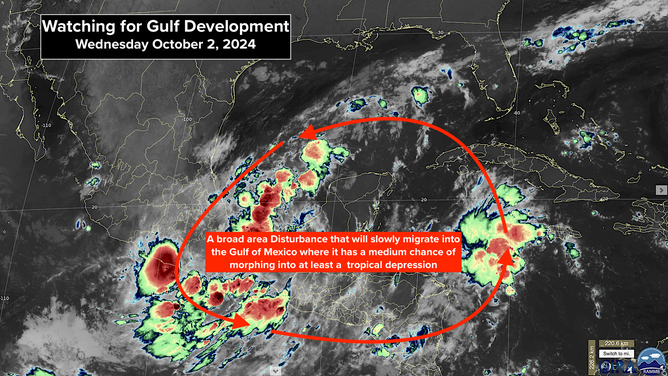
The tropical disturbance we followed across the Caribbean has merged into the broad low-pressure area over Central America. That entire Central American Gyre – a gyre is a large rotating system – is forecast to ease north over the Gulf of Mexico late in the week and into the weekend. Within that large, low-pressure zone, an organized tropical system might develop over the days that follow.

The Central American Gyre is highlighted.
(NOAA / FOX Weather)
There are lobes around the edge of the gyre producing clusters of thunderstorms. In the western Caribbean Sea, thunderstorms on the edge of the gyre are being enhanced by an upper-level disturbance. In the extreme southwestern Gulf of Mexico, the gyre combined with a weak surface disturbance are already producing strong winds. And in the Pacific south of Mexico, a tropical depression has formed on the edge of the gyre there.
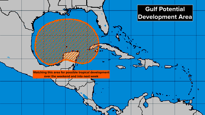
The National Hurricane Center has the odds in the medium range that at least a tropical depression will form in the Gulf of Mexico. Their potential development area covers the entire Gulf, reflecting the size and scope of the parent area of low pressure – that is, the gyre.

The outlook for an area being watched in the Gulf of Mexico.
(NOAA / FOX Weather)
The various computer models predict development in the Gulf, but in different locations and of different strengths. The good news is that nothing is going to happen fast. Large circulations take time to consolidate.
A strong band of hostile upper-level winds is forecast to cover the northern Gulf well into next week, which should keep whatever develops from getting terribly strong. Although anytime a tropical system develops over the warm waters of the Gulf, we don't want to jump to conclusions.
Many of the computer forecasts indicate that whatever system develops will move toward the Florida Peninsula at some point next week. Exactly when during the week is an open question.
For now, we'll plan to watch for developments over the weekend.
Don't look at any individual forecasts now. As always, predictions for disturbances that are just developing are likely to have large errors and are subject to big changes.
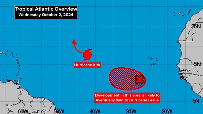
BETWEEN THE CARIBBEAN AND AFRICA: Hurricane Kirk is forecast to strengthen into at least a Category 3 as it heads north into the open ocean. The disturbance behind it, officially tagged Invest #91L, also appears likely to become a strong hurricane. This one might track farther west but is still expected to turn north before reaching the islands.

The outlook for Hurricane Kirk and a disturbance near Africa.
(NOAA / FOX Weather)
