Bryan Norcross: Watching for slow development of a wet system in the Gulf this weekend
The ingredients for the potential Gulf system are coming into focus, though it's looking less likely that it will turn into an organized tropical depression or tropical storm.

FOX Weather is your Hurricane HQ.
(FOX Weather)
Updated at 9:30 a.m. ET on Thursday, Oct. 3, 2024.
The ingredients for the potential Gulf system are coming into focus, though it's looking less likely that it will turn into an organized tropical depression or tropical storm.
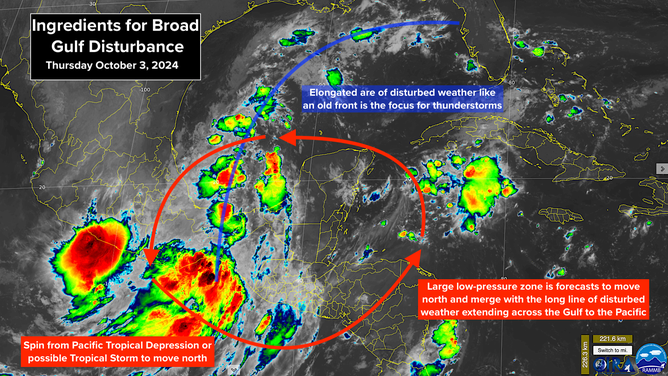
Satellite imagery indicating low odds that tropical depression will organize
(NOAA)
To the north, a long line of disturbed weather like an old front extends from Central Florida into the Bay of Campeche in the southwestern Gulf of Mexico and into the Pacific. To the south, the expansive low-pressure system called the Central American Gyre (CAG) reaches across the whole region. In the Pacific, a tropical depression, which could briefly turn into a tropical storm, is moving north toward the Gulf.
Over the next few days, the CAG and the Pacific depression or storm will migrate north into the Gulf and essentially merge with the existing line of disturbed weather into one system.
The National Hurricane Center is drawing a potential development zone covering most of the Gulf of Mexico because it's unclear where or if an organized tropical system might develop from that combination. They now have the odds in the low range that a tropical depression will organize. In any case, however, a lot of tropical moisture will be involved.
Moving into next week, another cold front will press into the northern Gulf along with hostile upper-level winds. This regime will stretch the moisture and whatever form the merged weather system takes west to east south of the front and generally push the disturbed weather toward Florida.
Whether an organized tropical system develops out of the mishmash of weather systems and moisture or not, an extended period of rain looks likely, especially over the central and southern parts of the Florida peninsula, beginning over the weekend and continuing into next week. Heavy rainfall is possible, depending on the possible tropical development in the Gulf.
Currently, the possibilities range from a disorganized but very wet system to a tropical depression or tropical storm with an organized system having lower odds. The upper-level winds are not forecast to be conducive for a hurricane to develop, although we have to keep our mind open to all possibilities whenever a potential tropical system might organize over the warm waters of the Gulf.
Everybody in Central and South Florida should plan to stay informed over the weekend and be ready for a wet stretch of weather ahead.
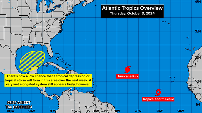
In the Tropical Atlantic, Hurricane Kirk set a record by forming the closest to Africa that any hurricane in the record book formed at this time of year. It's forecast to turn north into the open Atlantic as a giant and powerful storm. The huge circulation will put a lot of energy into the ocean, which will show up as strong swells and powerful waves along the Atlantic coast beginning about Sunday.
Right behind it, Tropical Storm Leslie may top Kirk's record and become a hurricane even farther east. It will also turn north and avoid land. It's not as big a system, so its effects on the U.S. East Coast should be minimal.
There might be one more disturbance to watch coming off of Africa this month, although the computer forecasts don't show significant development. Our attention moves to the Caribbean, the Gulf, and the Atlantic waters around Florida for the rest of the hurricane season, if things go anything like normal.
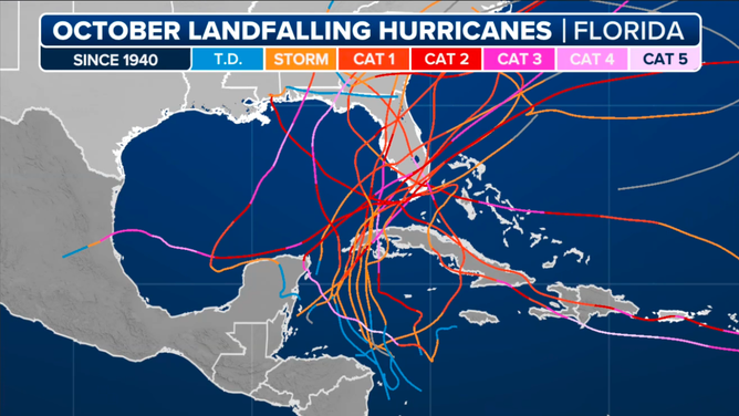
(NOAA)
Here are the tracks of the hurricanes that impacted Florida during October in the official record. Notice the South Florida has often been the focus, and generally they have come out of the Caribbean. So, if a system develops next week and tracks east, it won't be a freak.
We'll see. This season has been anything but normal so far.