Bryan Norcross: Gulf development still possible with heavy Florida rains likely
The National Hurricane Center has the odds in the medium category that a tropical depression or tropical storm will form.

FOX Weather is your Hurricane HQ.
(FOX Weather)
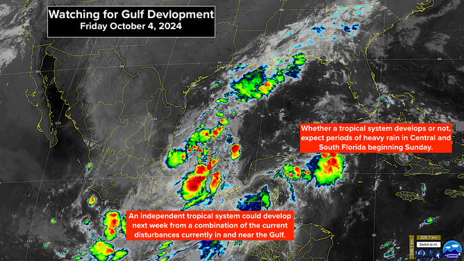
The ingredients are: an elongated area of disturbed weather across the Gulf that includes an area of low pressure offshore of the Mexican coast, a large low-pressure system over Central America, and the remnants of a tropical depression from the Pacific Ocean. The three separate systems are forecast to merge over the weekend into a single large disturbance stretched out over the Gulf of Mexico. The system will be broad and disorganized but will hold a lot of moisture.
By early next week, a cold front and a band of very hostile upper winds will be pushing into the northern Gulf. Eventually, the front and the tropical disturbance will likely merge, but there might be a window of opportunity for an organized tropical system to spin up around Tuesday or Wednesday.
The setup in the Gulf of Mexico.
(FOX Weather)
The National Hurricane Center has the odds in the medium category that a tropical depression or tropical storm will form. The consensus of the various computer forecasts is that the existing low near Mexico will be the catalyst for an independent tropical system, if the front and hostile upper winds give it a chance. The system would likely track west to east in a stream of tropical moisture across the central or southern Gulf.
Whatever shape the system takes, an extended period of rain is likely for the Florida Peninsula. On the current schedule, rain chances increase by Sunday, especially south of I-4, and continue through much of the week. The front will eventually push down the state clearing North and Central Florida first, but a wet weather pattern could well continue in South Florida.
The rain will likely come in waves, depending on what kind of tropical system is able to develop south of the advancing front. Tropical moisture and a fall cold front often result in heavy rainfall. Some parts of Central and South Florida could receive up to a foot of rain, depending on where the moisture stream ends up focusing.
As always, forecasts for undeveloped or just developing systems are subject to significant changes, and this one has an especially large number of moving parts. Stay informed, especially in Central and South Florida.
The outlook for the Atlantic as of Oct. 4, 2024.
(FOX Weather)
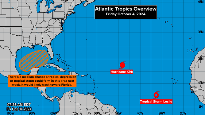
OUT IN THE ATLANTIC, Hurricane Kirk strengthened into a giant Category 4. It won't threaten land directly, but it's putting a tremendous amount of energy into the ocean. Strong swells and dangerous waves will arrive at the US East Coast about Sunday and last too early next week.
Right behind Kirk, Leslie will be a medium-sized hurricane. It will also put energy into the ocean, which will reach the East Coast late in the week, but to a lesser degree.
As we saw with Hurricane Helen, large-diameter storms are extraordinarily dangerous. They move a lot of seawater, and they carry a tremendous amount of tropical moisture.
Leslie looks likely to be our last named storm in the tropical Atlantic this season. Now, our focus will be on systems that develop in the Caribbean, the Gulf of Mexico, or the Atlantic waters near Florida.