Bryan Norcross: Gulf hurricane forecast has Peninsula Florida on alert for a high-impact storm
Tropical Depression Fourteen will likely be upgraded to Tropical Storm Milton as soon as later today. It's forecast to become Hurricane Milton by Monday.

Tropical Depression Fourteen forms in Gulf of Mexico
Tropical Depression Fourteen formed in the Gulf of Mexico Saturday morning. "This has the potential to be worse than Helene for parts of the west coast (of Florida)," said FOX Weather Hurricane Specialist Bryan Norcross on Tropical Depression Fourteen.
Updated Saturday 9 a.m. ET
The broad tropical disturbance we have been discussing for days is consolidating quickly in the western Gulf of Mexico. The National Hurricane Center has designated it Tropical Depression Fourteen. It will likely be upgraded to Tropical Storm Milton as soon as later today. It's forecast to become Hurricane Milton by Monday.
Winds near the system are already near tropical storm force. The various computer forecast models are in increasing agreement that the storm is going to strengthen, and it will move toward the Florida Peninsula.
The National Hurricane Center is now forecasting Hurricane Milton to make landfall on the West Coast of Florida as a top-end Category 2. That means we need to prepare for at least a Category 3. Some credible computer models predict a Category 4.
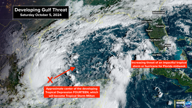
Developing Gulf Threat.
(CIRA / RAAMB / FOX Weather)
On the current schedule, the storm would arrive at the Peninsula around Wednesday, although winds could increase late on Tuesday. Well in advance of the storm, waves of heavy rain are forecast beginning tomorrow, especially in Central and South Florida.
It's too early to predict how much storm surge this system could generate on Florida's West Coast, but it will be significant and dangerous. In some areas, it will likely be higher than in Hurricane Helene.
The storm surge threat will be defined as the system organizes and starts moving closer to Florida. Expect detailed information from the National Hurricane Center, including Hurricane and Storm Surge Watches and Warnings, beginning tomorrow.
The West Coast of Florida is spectacularly vulnerable to storm surge, as we have seen. Even a tropical storm can push the Gulf water to dangerous heights, let alone a strong hurricane. It's critical that everybody in Central and South Florida stay well informed since things are developing quickly.
About the time Milton approaches Florida midweek, a cold front and a band of hostile upper-level winds will press south into the Gulf. How the front, the upper winds, and the potential hurricane will interact is still an open question, but the system could start spreading out in a transition to something more like a nor'easter. As we've seen, a spread-out storm produces more storm surge.
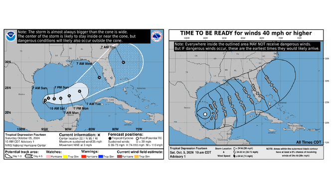
Tropical Depression Fourteen track.
(National Hurricane Center / FOX Weather)
Don't get hung up on the meteorology of it. The bottom line is, the odds are increasing of an impactful and dangerous storm for parts of the Florida West Coast and Peninsula.
Don't pay attention to individual computer forecasts. As always, they are expected to jump around as the system develops. The important point is that there is the increasing likelihood of a significant storm surge event in all of the highly populated regions on Florida's Gulf coast.
In addition, up to a foot rain could fall in some locations. It's impossible to know where in Central or South Florida at this point, but flooding is certainly possible.
On the current schedule, the system would move through by Thursday pulling a cold front down the peninsula, which will usher in cooler and drier fall weather.
Things are going to change fast, so plan to stay informed. We'll be covering it on Fox Weather, of course. If you don't get the channel, go to FoxWeather.tv. You'll find the info on how to watch on your TV, computer, iPad, or phone. It's always free.
Stay informed. Things could develop fast.
OUT IN THE ATLANTIC: Hurricane Kirk flirted with Category 5 strength. It's heading north into the open Atlantic as a large Category 3 hurricane. Strong swells, causing beach erosion and dangerous surf, will reach the US East Coast tomorrow into Monday. It is forecast to threaten the United Kingdom next week.
Right behind it, Hurricane Leslie is also turning north. It will produce swells along the East Coast as well. They'll come later in the week but not be as strong as those produced by Kirk.
The National Hurricane Center is painting an area off the African coast where another disturbance could develop. At the current time, however, the odds are in the low category. Whatever happens with that, it's also likely to turn north into the open Atlantic.