Bryan Norcross: Hurricane Milton increasingly likely to cause extreme impacts along Florida's west coast
If Hurricane Milton makes landfall in Florida anything like the current forecast, it will be the worst hurricane disaster in modern times in the parts of the Florida west coast that receive the highest surge.

FOX Weather is your Hurricane HQ.
(FOX Weather)
Updated at 10 a.m. ET on Monday, Oct. 7, 2024
There is a lot to say about Hurricane Milton. But here are some key points:
- There is no way to know for sure if the Tampa Bay area will take a direct hit. It's too close to call.
- If the center jogs just south of the entrance to Tampa Bay, the situation in Hillsborough and Pinellas Counties will be bad, but not catastrophic. If the center comes ashore just north of the Bay, the surge will be significantly worse than Helene. Vast areas around Tampa Bay, including much of Pinellas County and downtown Tampa, will go underwater.
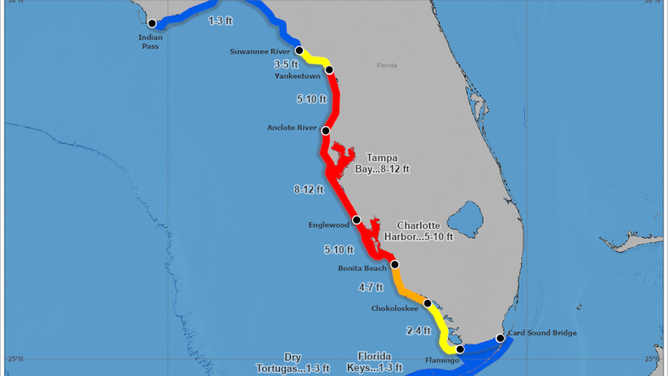
- The Gulf water will be pushed up to 12 feet above normal high tide along the entire densely populated west coast of Florida near and south of where Milton's center comes ashore. Know the forecast for your area and evacuate if ordered.
- Hurricane-force winds will spread across the state on both sides of the storm track. In fact, the strongest winds and highest flood potential will likely be north of the track of the storm. Tornadoes are possible ahead of and to the right of the storm track.
- Unless we get extremely lucky, Milton will be one of the biggest hurricane disasters in history.
- Hurricane Watches and Storm Surge Watches have been issued for large parts of Florida. Most of the areas covered by the watches will go under Hurricane and Storm Surge Warnings as the storm gets closer. Watches mean danger is possible. Warnings mean action is required.

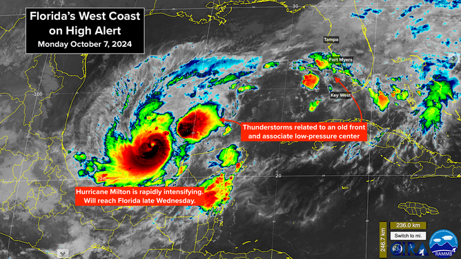
Satellite image of Hurricane Milton's rapid intensification.
(NOAA)
Hurricane Milton is exploding in intensity. By taking an extremely unusual track across the Gulf slightly farther south than forecast, Milton has a long runway in an atmospheric environment that is forecast to be extremely conducive to strengthening. The National Hurricane Center is predicting Milton to reach near Category 5 intensity over the Gulf. Some of our best computer models forecast it reaching Cat 5.
In the last day before landfall on Florida's west coast, which is currently scheduled for the second half of Wednesday or early Thursday, the atmospheric pattern will dramatically change. Strong upper winds from the jet stream and dry air will increasingly affect the storm as it curves to the north and approaches the coast.
Jet-stream interaction is common with October hurricanes. It can alter the storm in a few ways: The peak winds decrease, the radius of strong winds expands (increasing the storm surge zone), and stronger winds and exceptionally heavy rain occur on the left or the traditionally "weak" side of the storm.
If this scenario plays out as forecast, Milton will be a super-intense, relatively compact storm over the Gulf on Tuesday, then evolve into a somewhat weaker but more spread-out hurricane by landfall time late Wednesday or Thursday.
As we saw with Hurricane Helene, large-diameter storms generate higher storm surge, even if the peak winds in the storm are less intense.
In the end, all of that is meteorological mumbo-jumbo. The bottom line is, if Hurricane Milton makes landfall in Florida anything like the current forecast, it will be the worst hurricane disaster in modern times in the parts of the Florida west coast that receive the highest surge.
A major hurricane hasn't hit the Florida west coast south of the Big Bend and north of the Fort Myers/Punta Gorda area in over 100 years. Hopefully, Helene's impacts will help residents imagine what could happen if a direct hit from a powerful storm were to occur – imagine Helene, plus at least a few more feet of water.
This threat requires immediate action. Mandatory evacuation orders have been issued or will be issued for residents in affected areas.

Peak storm surge forecast for Florida's west coast.
(NHC)
Impacts on Florida
SURGE: The deadliest of the multiple hazards that will come with Hurricane Milton will be the storm surge at the coast and in the bays, harbors, inlets and rivers near and south of when the center of the circulation makes landfall.
Gulf water will be pushed to unsurvivable levels along the west coast. Large-scale, painful and difficult evacuations will be required.
A Storm Surge Watch means that life-threatening water levels are possible at that location.
The current forecast is for Gulf water to rise up to 12 feet above the normal high-tide line and spread well inland in the peak surge zones. It's critical that everyone on Florida's west coast know the forecast for their area. And critically, follow the instructions of local officials. They are working with the National Hurricane Center to keep you safe.
Evacuation zones are drawn because those locations are vulnerable to storm surge. Just because it hasn't flooded since you've been there, doesn't mean the possibility hasn't always existed. As we saw in hurricanes Ian and Helene, once the water is rising, you can't get away.
WIND: Strong winds will cover a large part of the Florida Peninsula. Hurricane-force winds will impact the Gulf Coast, obviously, but a sprawling hurricane moving at a good clip will likely bring hurricane winds to inland Central Florida as well. People in the Orlando area should think about Hurricane Charley, but more widespread. There will likely be a corridor across Central to Northeast Florida where the wind and rain will be especially intense.
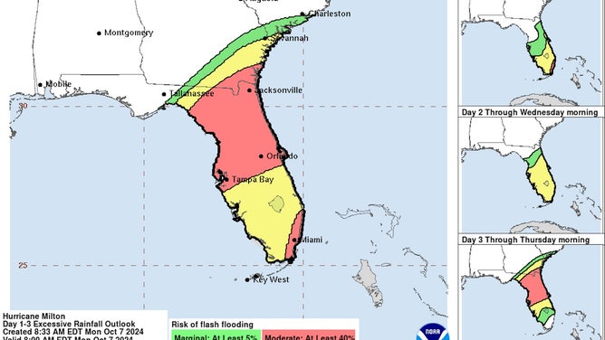
RAIN: Heavy rain is forecast to add up over a large part of the Florida Peninsula. The first round of rain over the state yesterday and today will dump several inches in some areas. The non-tropical disturbance producing this round of tropical downpours will move past the Bahamas tomorrow. Tuesday looks less rainy as we await the arrival of Hurricane Milton on Wednesday or early Thursday.
Rain totals in some areas will likely exceed a foot, so flash flooding is likely. Don't drive through flooded areas. A road and a canal look the same when they are covered by water.
Tornadoes are likely as Milton crosses the state, especially ahead of and to the right of the track. Be sure you ride out the storm in a safe interior part of your home.

Flash flood risk for Florida.
(NHC)
Time to prepare
With Milton's landfall scheduled for Wednesday – two days from now – it's time to make concrete plans and decide if you can stay home. Here is the list I published less than 2 weeks ago for people in the path of Hurricane Helene, with a few adjustments for this situation.
• Follow evacuation orders if they are issued for your area. You are risking yourself and your family if you ignore them.
• Don't try to be an amateur meteorologist and out-think the experts who dedicate their lives studying how to keep you safe.
• If you are in the potential high-impact zone or are evacuating, call a friend or relative out of town and designate them as the contact hub. Give your local friends and family that number. If local services are out after the storm, you all have someone to check in with when you are able.
• Plan for the power to be out for an extended period of time.
• DO NOT turn your fridge down to a lower setting.
• Think about important papers and other items in the house that you want to be sure are safe. If you think your home could be compromised, plan to put them into heavy-duty trash bags. Your dishwasher, washer and maybe the dryer are good places to put the bags. Be sure your dryer can't flood through its vent.
• Get some duct tape and plastic painter's sheets – the kind you put on the floor when you paint the walls. If the storm is coming your way, put a plastic sheet in the bathtub and fill it three-quarters full of water. That water will be used to flush toilets and for cleaning up if your water supply goes out. It's a good idea to do that, even if you're evacuating. When you get back, the water supply might still be out.
• Use the same painter's sheets to cover furniture and electronics if necessary. Use duct tape liberally.
• If you haven't done it already, pick up your hurricane food and water immediately. Even inland, you could get stranded at home while streets are being cleared. And if you end up evacuating, you'll need your supplies.
• You don't need gallons and gallons of store-bought water. Pots and pans and pitchers at home filled with tap water will work just fine. Don't worry if the store is out of water. Buy empty jugs. If you use a new bucket or some other container to hold tap water, wash it with soap and water so it's sanitary. I would fill it with warm water and some bleach, then wash it out to be sure.
• Have a plan for where you'll park your car where a tree can't fall on it and a flood can't get it. A parking garage is a great option if there is nowhere safe close by.
• Now is the time to plug in any rechargeable batteries for things like power tools (for post-storm cleanup and repair), lights and tech (power banks). Keep everything charged.
• If you're evacuating to a hotel, book directly with the hotel, not through a third-party website or service.
• Gas up the car, get extra cash, and buy a supply of important prescription drugs today. Don't wait.
• Plan for animals and pets now.
This is going to be a day-by-day thing. Stay informed. Forecast adjustments are still likely.