Bryan Norcross: Hurricane Milton on track to bring catastrophic impacts to Florida's west coast
We all hope for the best, but some areas will likely see the worst impacts ever caused by a hurricane in modern times.

FOX Weather is your Hurricane HQ.
(FOX Weather)
Updated at 10:30 a.m. ET on Tuesday, Oct. 8, 2024
There is a lot of detail below about the storm, its potential or likely impacts, and the warnings in effect across Florida. Most locations in the state are being warned about dangerous weather to come.
(CIRA/RAMMB)
The impacts from Hurricane Milton will range from disruptive to deadly. Disruptive weather generally means you can stay home, and if you use common sense, you'll be okay. But if extreme conditions are possible in your area, like where Gulf or ocean water might rise to an unsurvivable level, you have to leave. Now. Immediately.
There is nothing to be confused about here. There are warnings for seawater rise (storm surge), wind (Hurricane or Tropical Storm Warnings) and flooding from heavy rain. All of these hazards are dangerous, but storm surge is the one that kills the most people in a Florida hurricane.
Yes, you might have "been through hurricanes before." But you weren't through the 1921 storm that put water over much of Pinellas County, or the 1848 hurricane that put 15 feet of Gulf water where downtown Tampa is today.
Before Hurricane Ian hit Southwest Florida, some people got confused, ended up making terrible decisions, and died. Don't let that happen to you.
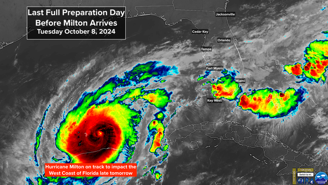
Hurricane Milton
Hurricane Milton put on a stunning display of intensification yesterday. Few storms in modern times have intensified as quickly or become as strong. The eye diameter shrunk to less than 5 miles across. Like a figure skater pulling in her arms to spin faster, the hurricane's peak winds jumped to 180 mph.
Subsequently, internal processes caused a large eye to develop (like the skater's arms extending out), and the top wind number dropped to a Category 4. In addition, the storm grew in size as a new eye structure formed. In spite of the drop in wind speed, none of this is good news for the west coast of Florida.
Tomorrow, Milton will turn north in the direction of west-central Florida – in the general direction of Tampa Bay. At the same time, the dip and the jet stream that is directing it north will drive the storm into a band of strong upper winds and dry air. That hostile environment should weaken Milton further, but also spread the strong winds farther from the center. The storm is forecast to more than double in size before it reaches the coast.
The storm's size is a bigger factor in generating storm surge than the peak wind speed. This is why Storm Surge Warnings are in effect for the entire west coast of Florida, and the threat of the Gulf water being pushed to deadly levels is so real.
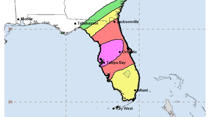
Storm surge forecasts and evacuations
The National Hurricane Center is predicting up to 15 feet of storm surge could inundate areas in and around Tampa Bay and down the Gulf Coast to Englewood. If that prediction comes true, the high tide will be 15 feet above normal – unsurvivable. Predictions in and around the Fort Myers area are for up to 10 feet above normal. These forecasts don't imply that the entire area will receive that level of storm surge but that somewhere in those forecast zones, the water will reach those levels if the maximum surge comes in at high tide.
If the center of Milton's circulation passes over or just north of Tampa Bay, there could be a double surge. First, the winds on the right side of the circulation would push the water into the bay. But after the center moves inland, the backside of the storm could also push water into the bay. In addition, the changing wind direction would flood one side of the bay and then the other. A track just north of the city presents a series of extraordinarily dangerous scenarios.
Evacuations are ordered to be sure that people aren't in areas that could be inundated with wind-driven Gulf water. If you're in an evacuation zone and you don't leave, you're taking a risk. Nobody can rescue you if you find out too late that you made a mistake.
Once Milton crosses the state, the winds on the north side will come off the Atlantic and drive storm surge back toward the Florida, Georgia and South Carolina coast, which will likely flood into harbors and inlets, including down the St. Johns River.
Winds spread inland
Winds will spread inland, especially along and north of the track of Milton's center. This might seem unusual since we normally talk about higher impacts on the right side of the track. In this case, and often in October, however, the strong upper-level winds that will cause Milton's weakening will also enhance thunderstorm development on the north side of the storm.
Flash flood risk for Florida.
(NOAA's Weather Prediction Center)
Flash flooding
The highest likelihood of flash flooding is also related to this enhancement by the jet stream winds. The National Weather Service puts the flash flooding threat at level 3 out of 4 for most of North and Central Florida and 4 out of 4 along and just north of the I-4 corridor.
The schedule
On the current schedule, winds will increase overnight tonight in the Florida Keys and Southwest Florida. Through the day Wednesday, strong winds will spread up the coast and across the state.
The peak push of storm surge will come around landfall, which is now scheduled for the late-evening hours of Wednesday or just after midnight Thursday morning. Thursday, Milton will pass into the Atlantic, and we'll watch for storm surge from Central Florida to South Carolina.
Last day to prepare
Today is the last full day for preparation on Florida's west coast. Here's the list of tips I published yesterday in case it helps.
• FOLLOW EVACUATION ORDERS if they are issued for your area. You are risking yourself and your family if you ignore them.
• Don't try to be an amateur meteorologist and out-think the experts who dedicate their lives studying how to keep you safe.
• If you are in the potential high-impact zone or are evacuating, call a friend or relative out of town and designate them as the contact hub. Give your local friends and family that number. If local services are out after the storm, you all have someone to check in with when you are able.
• Plan for the power to be out for an extended period of time.
• DO NOT turn your fridge down to a lower setting.
• Think about important papers and other items in the house that you want to be sure are safe. If you think your home could be compromised, plan to put them into heavy-duty trash bags. Your dishwasher, washer and maybe the dryer are good places to put the bags. Be sure your dryer can't flood through its vent.
• Get some duct tape and plastic painter's sheets – the kind you put on the floor when you paint the walls. If the storm is coming your way, put a plastic sheet in the bathtub and fill it three-quarters full of water. That water will be used to flush toilets and for cleaning up if your water supply goes out. It's a good idea to do that, even if you're evacuating. When you get back, the water supply might still be out.
• Use the same painter's sheets to cover furniture and electronics if necessary. Use duct tape liberally.
• If you haven't done it already, pick up your hurricane food and water immediately. Even inland, you could get stranded at home while streets are being cleared. And if you end up evacuating, you'll need your supplies.
• You don't need gallons and gallons of store-bought water. Pots and pans and pitchers at home filled with tap water will work just fine. Don't worry if the store is out of water. Buy empty jugs. If you use a new bucket or some other container to hold tap water, wash it with soap and water so it's sanitary. I would fill it with warm water and some bleach, then wash it out to be sure.
• Have a plan for where you'll park your car where a tree can't fall on it and a flood can't get it. A parking garage is a great option if there is nowhere safe close by.
• Now is the time to plug in any rechargeable batteries for things like power tools (for post-storm cleanup and repair), lights and tech (power banks). Keep everything charged.
• If you're evacuating to a hotel, book directly with the hotel, not through a third-party website or service.
• Gas up the car, get extra cash, and buy a supply of important prescription drugs today. Don't wait.
• You need a plan for your pets and animals. Every Florida county has a shelter that allows pets.
We all hope for the best, but some areas will likely see the worst impacts ever caused by a hurricane in modern times.