Bryan Norcross: Francine is organizing as it heads toward landfall in Louisiana tomorrow
The outer bands of Tropical Storm Francine have reached southern Louisiana. Tomorrow, strong winds, flooding rain and life-threatening storm surge will impact much of the southern part of the state as the core of the storm makes landfall.

Bryan Norcross: How quickly Tropical Storm Francine might develop
FOX Weather Hurricane Specialist Bryan Norcross provides his analysis of the 5 p.m. ET National Hurricane Center advisory, which put metro New Orleans under a Hurricane Watch. He also explains how quickly intensification might occur for Tropical Storm Francine. Sept. 10, 2024.
Updated at 10:30 a.m. ET on Tuesday, Sept. 10, 2024
Welcome to the peak day of hurricane season as defined by named storms. This is the date that, on average, there is most likely to be a named tropical storm or a hurricane in the Atlantic, the Caribbean, or the Gulf of Mexico.
Today in the Gulf of Mexico, the outer bands of Tropical Storm Francine have reached southern Louisiana. Tomorrow, strong winds, flooding rain and life-threatening storm surge will impact much of the southern part of the state as the core of the storm makes landfall. The environment around Francine appears conducive for strengthening through today and tonight.
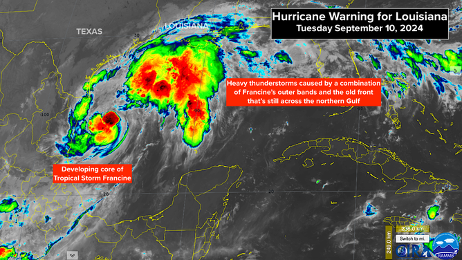
Satellite image of Francine heading for Louisiana
(NOAA)
The flood threat from heavy rain will spread north and include southern Mississippi and into the Mid-South.
The National Hurricane Center is predicting that Francine will be at Category 2 strength at landfall, which means that preparations should be made for at least a Cat 3. On the current schedule, the center will cross the coastline after noon tomorrow, though some computer projects are considerably slower.
There is some indication that the atmospheric environment might change in the hours right before Francine's center makes landfall. Strong upper-level winds are forecast to increase over the storm, pushing dry air into the circulation. If the hostile conditions develop, they could stop the strengthening process or even weaken the storm as it's coming ashore. It's too close to call, however, whether that will happen soon enough to significantly affect the wind, rain, and storm surge impacts.
Along some part of the coast near and to the right of where Francine's center of circulation comes ashore, the Gulf water is forecast to rise up to 10 feet above the normal high tide level. Evacuations have been ordered for vulnerable areas.
A Storm Surge Warning is in effect for the entire south coast of Louisiana and the extreme upper Texas coast.
There is also a storm surge threat in the greater New Orleans area where Lake Pontchartrain and Lake Maurepas could be pushed up to 4 feet above normal levels if the strongest winds in Francine impact the lakes. Stay up to date on the latest instructions and information if you are in the affected areas.
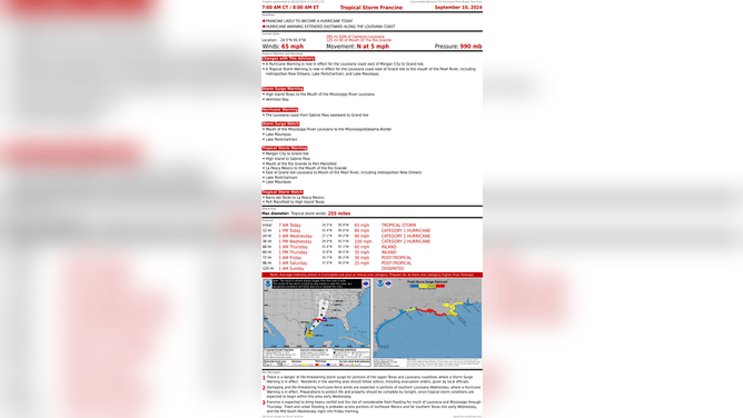
Fraincine likely to become a hurricane today
(NOAA)
The exact landfall point on the coast is unknowable, so let's not guess. The computer forecasts give us confidence that Francine's center will track within the cone, but the various predictions have been shifting right and left as Francine has been developing. The National Hurricane Center takes a middle-of-the-road position because that most often yields the best prediction. The timing of landfall is also subject to change, so don't lock into any one forecast.
Francine will quickly weaken as it moves over land. However, it might spawn some tornadoes ahead and to the right of the track.
Stay aware and stay informed.
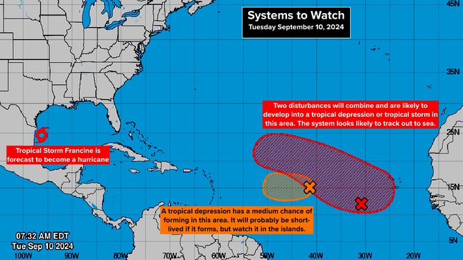
Two disturbances to monitor in the Atlantic
(NOAA)
In the Tropical Atlantic between the Caribbean and Africa, there are two systems to watch. The one on the left was tagged Invest #92L by the National Hurricane Center. It still has a medium chance of developing into at least a tropical depression late in the week.
The computer forecasts don't do much with this system. But since it's forecast to head toward the waters near or just north of the Caribbean islands, residents there should keep an eye on it.
A little bit closer to Africa, two systems are likely to come together and eventually develop into a tropical depression or tropical storm in the red-shaded area. Computer forecasts predict that the combo system will eventually develop into a strong storm, but a break in the high pressure to the north should keep it well away from land.
The next name on the list is Gordon, and the one after that is Helene.